DTS Off?
-
Coming back from a mission, I got jumped by a pair of 29s, so I let fly 4 slammers(2 misses, 2 hits on same 29), jettisoned my stores and burned for home. Looking up at the HUD, I noticed this “DTS OFF”, also on the DED. I did a search of the manuals and couldn’t find anything. Anybody have an idea what that is?
-
You accidentaly pressed the “3” on the ICP.
DTS is for the Digital Terrain System. The DTS Page is not implemented.
Cheers,
Scubps. interesting is that depending on the block type, the “3” may also be used as the Fault Acknowledge Page button. Hardly visible but it’s there above the “3”, it says F-ACK:
The Faults are displayed on the DED instead, which would be displayed on the PFL for the current BMS cockpit model (Block 50/52)
-
Wow… I looked for a bit of time before AND after I posted, and I STILL wasn’t able to find the answer. Thanks for the reply/info:D
-
Was DTS implemented on any jets other than USAF block 40/42s?
-
Was DTS implemented on any jets other than USAF block 40/42s?
Yes. I think about Belgian MLU at least …
ASUSTeK ROG MAXIMUS X HERO / Intel Core i5-8600K (4.6 GHz) / NVIDIA GeForce RTX 3080 Ti FE 12GB / 32GB DDR4 Ballistix Elite 3200 MHz / Samsung SSD 970 EVO Plus 2TB / Be Quiet! Straight Power 11 1000W Platinum / Windows 10 Home 64-bit / HOTAS Cougar FSSB R1 (Warthog grip) / SIMPED / MFD Cougar / ViperGear ICP / SimShaker JetPad / Track IR 5 / Curved LED 27'' Monitor 1080p Samsung C27F396 / HP Reverb G2 VR Headset.
-
On MLU’s and all Block 50/52’s.
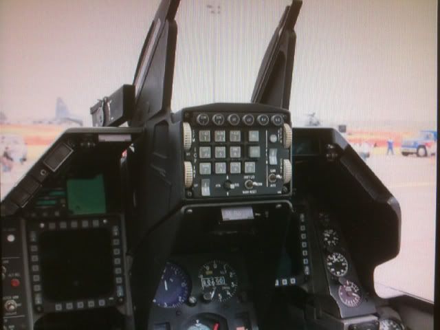
BTW, there where 2 versions of the ICP on the Viper, the top is the known one and used on and above Block 40/42’s, to support the LANTIRN, FLIR and TFR functions. The bottom ICP is the old one used on the previous Block 30/32’s. Except the F-ACK on button 3, the differences are on the PLRT for polarity button vs WX for the weather mode of the TFR, and the INT thumbwheel instead of BRT for FLIR brightness.


-
Digital Terrain System (DTS)
The DTS is a digital representation of 480 NM^2 of terrain loaded into the data tape cartridge (DTC). The F-16 uses this digital terrain for a number of different things:
Database terrain cueing (DBTC): With the radar altimeter on, the actual terrain the F-16 is flying over is compared against the database to determine position on the digital terrain. This information is combined with the INS and GPS and used in position fixing. When flying in an area without DTS coverage, the words “OFF MAP” appear below the ASI on the HUD.
Proximity to ground collision avoidance system (PGCAS): Without the DTS, the airplane assumes a “flat earth” for the PULL-UP cues (in other words; it’s only effective if flying over the ocean or perfectly flat land). With the DTS, the jet can give accurate PULL-UP cues over mountainous terrain. To differentiate between cues given by the existing ground-proximity warning system and PGCAS, a separate terrain-proximity warning (along with the break-X on the HUD) will appear below the ASI. If PGCAS is not available, a “NO GPW” warning is displayed on the HUD.
Obstacle warning/clearance (OW/C): Along with a terrain database, the DTS includes information on man-made obstacles (height and position). The HUD will display “OBSTACLE” when nearing an obstacle, and “<- OBSTACLE” or “OBSTACLE ->” when one is to the left or right of the aircraft.
The DTS is configured from the DTS page on the DED, ICP button 3. From this page you can turn on and off different DTC features and configure minimum altitudes.
some more DATA for PGCAS …
-
Will DTS provide CCIP terrain surface when FCR is off?
-
No, not actually a “sensor” solution for firing live ordinance through this system accuracy.
-
Raptor I would advise that your answer is dependent on which F-16 the question is being asked for.
1.22.6 Passive Ranging (PR). The digital terrain system (DTS) passive ranging function provides MSL terrain elevation for
a given target position. The range to target position is provided to DTS by the MMC. The DTS PR function uses this range
information to determine the elevation of the terrain at the base of the target using the digital terrain map stored in the DTS/DTC.
The PR function is available when DTS is in TRK as displayed on the DED and the target position is less than 5.4 nm from the
TRN navigation position.
1.22.6.1 The PR function is selected via the backup bombing-sensor rotary on the MFD when the primary sensor FCR, is in
standby or off. With DTS in TRK, PR is available as an A-G ranging sensor when either run QUIET or run SILENT is selected.
PR is identified in the HUD with a P to the left of the slant range display. For specifics on PR selection, see AIR-TO-GROUND
SENSORS (2.8.3). -
Neato, that’s how the A-10C accomplishes terrain ranging without any radar at all, that or a manually-entered elevation. Can the F-16 do manual target elevation if neither AGR nor DTS are available? I think I read that without AGR the jet assumes the elevation of the target is the same as the current steerpoint or something like that. That would be one way to do it.
-
Its a priority thing. So if you have TGP laser ranging to the target, that information is used. If not, AGR is used, then DTS PR, the the radar altimeter, then steerpoint elevation vs the barometric altimeter.
Different again if you want to use CCRP, because then it looks at FCR tracking data or TGP passive ranging (No clue about that…!) as more useful than DTS PR.
-
Makes sense. I could see radio altimeter is not necessarily superior to steer elevation in a rugged area with a well-planned steer.
-
well if you turn off the radar altimeter, then it goes down the list and uses stpt elevation instead. Seeing as if you are using CCIP its likely because you are not sure of the location and thus you want a visual delivery mode, there is no guarantee in that rugged area that the target is at the same elevation as your stpt.
90% of the time one imagines you could just turn the radar on and use AGR in that instance though.
EDIT: Now I would just love to see the AGR MFD page display the ground lock as well…
-
What does the AGR display apart from the blank-ish page we see in BMS?
-
Very little really, but its the kind of thing that would be neat to have. Probably pretty low on the priorities list.
1.8.7.3.3.3 MFD. Only the 10 NMI range scale is available. The AGR lock-on symbol is displayed along the right hand side
of the MFD. When the radar is locked on and providing valid slant range data, the symbol is a diamond. The diamond changes to
a square located at the last valid range when valid range can no longer be determined. An iron cross indicates antenna position
displayed with respect to the body axis of the aircraft along with antenna carets on the bottom and left side of the display.
So one step in most of the CCIP release procedures is to check that the AGR has a valid ground lock. In BMS it always knows its altitude, without fail. You can’t check that however, with no lock symbol.
Its the little things that are nice to have that make such a big difference sometimes. Like I said, probably a lot of work to do something with so little benefit to the majority of users.
-
Refernce about DTS
https://zenodo.org/record/1263276/files/article.pdf?download=1