Instrument landing system localizer off?
-
But at DME 6 no more step, you have to fly a glideslope.
you have to fly a computed vertical speed in relation to your GS until minimums or MAPT.
Caper … stop BS please … you really do know nothing about the subject.

Even you description about the markpoint tip is wrong! (to work, you have to put the markpoint on runway entry, not at the end!)
-
you have to fly a computed vertical speed in relation to your GS until minimums or MAPT.
Caper … stop BS please … you really do know nothing about the subject.
Even you description about the markpoint tip is wrong! (to work, you have to put the markpoint on runway entry, not at the end!)
So, you fly the VVI? That half of it. How do you know you’re heading into the tower?
DJ you need to chill and use some intuition. -
So, you fly the VVI? That half of it. How do you know you’re heading into the tower?.
… You do not really know, and this is why it is called non precision approach.
Caper, you are certainly a brillant engineer (?) I am not, and I will never try to teach you your RL job.
But there, we are plenty on mine … So I will try to find some docs to enhance your knowledges about IFR and instrument procedures, because you are totaly confused and seems to have absoluetly no idea about what it is actually, and how to proceed.
…
ASUSTeK ROG MAXIMUS X HERO / Intel Core i5-8600K (4.6 GHz) / NVIDIA GeForce RTX 3080 Ti FE 12GB / 32GB DDR4 Ballistix Elite 3200 MHz / Samsung SSD 970 EVO Plus 2TB / Be Quiet! Straight Power 11 1000W Platinum / Windows 10 Home 64-bit / HOTAS Cougar FSSB R1 (Warthog grip) / SIMPED / MFD Cougar / ViperGear ICP / SimShaker JetPad / Track IR 5 / Curved LED 27'' Monitor 1080p Samsung C27F396 / HP Reverb G2 VR Headset.
-
Your jumped into this page, I don’t if you are talking about mark pt, TCN, lLS and giving me shit.
Im not a engineer but I have dealt with enough of them. I’m a toolmaker, video/audio tech, Desktop and MPU programmer, for an Army contract I was a UAV testbed safety pilot, to payroll I paid as a lab tech. -
Legally you can descend immediately after the FAF to the MDA on a non-precision approach and fly level at MDA all the way to the VDP or MAP. There should be 250’ (75m) of obstacle clearance that whole way. Of course it is smart and advisable to make a calculated (and timed) descent smoothly from the FAF to the VDP. The way you do this is knowing what vertical speed matches your desired flight path angle and ground speed. This is doubly a good idea with ILS because it GS signal can have false lobes that are wrong (but show on GS indication). The only way to know is to discover descent rate (and thus angle) isn’t as expected. I think HUD or other indication of FPA is just fine for judging decent after FAF for non-precision approach. All that matters is not busting MDA and going missed the correct time after.
I don’t think caper is as wrong as you say. You have to fly a glideslope (not necessarily electronic) of some kind, he didn’t say how. And “end” could mean near end or far end. Runway has two ends. MDA/DH heights are quite variable. Cat I ILS is common 200’ ~1/3SM (RVR or airborne visibility?). Non-precision is more, 300-1000’ MDH 1+ SM.
-
I’m a toolmaker, video/audio tech,
Does’t change the fact that you are a specialist on your area.
-
I don’t think caper is as wrong as you say.
Yep, I see what you mean … But I doubt that our friends will understand the same and might easily goes into wrong assumption/conclusion.
")
-
Regarding some comments concerning the events of flight Norman 75
(Lt. Col. Dan “Two Dogs” Hampton) I have to say:I recommend to whoever is able to read / re-read the story as outlined
by the prolog and chapter 8 (which is actually the continuation of the prolog)
in his book. I’m certain that after a careful analysis of the events that led
to the landing at that airbase the remarks of “Bad flight management” and choices made not according
to what a “Good Pilot” will do won’t seem to fit here.
I agree with the “Trapped” notion but not with the part of “bad or miss evaluation” which I don’t see
as applicable to the events.The landing procedure as outlined in the story:
Regarding the airbase of landing Ali Al-Salem in Kuwait from what I found
it is likely that the air base was equipped with ILS (and maybe VORTAC).
This is based on 2 things:- From an internet search found in World Aero Data (and other sources too) for the airbase
that the runway used for landing (30L) has ILS and the airbase has VORTAC. - In the story he clearly refers to ILS and ILS bars.
The procedure itself in a skimmed form (please note that the airbase had no published procedures):
- First pass by “Two Dogs” only: Flying to airbase, contacting tower, electing runway to land, arranging for
runway lightings (+ approach lights), taking a mark point (set at ~1000ft from threshold) for approach and (implied) ILS intercept
(+ distance (DME) info. if we rule out VORTAC existence/usability by then). - “Two Dogs” passes details to other 9 flight members (including the mark point info.) and sequences the flight to landing.
- 2nd pass (with other fight members following): leading the way and verifying the approach , ILS intercept + guidance and conditions (runway vis.).
Informs other flight members (runway vis. 1 mile at 300ft) and himself executes a missed approach (others land) in order to be for a help if a flight member gets into a trouble. - “Two Dogs” commences a landing with deteriorating conditions (+ possible LG emergency: only 2 LG green lights) that compel him to violate the 200ft alt. minimum.
He eventually acquires vis. on the runway and lands.
I hope this clarifies the subject.
As for his discharge from the air force: Not true.
He was grounded by his OG for violating a 10000ft deck
during a combat mission. The violation occurred earlier the same day of the above mentioned landing
event and was necessary (mainly due to weather) for an emergency CAS response by him.
He heard of his grounding 2 days after his return to his home base from the divert.
His SQ/CC upon hearing of his grounding was “positively apoplectic (= angered, as someone having a stroke)”.
This also reached to some top command who were not only positive of his conduct but also gave some
negative attention to the OG. Of course they canceled the grounding the very same day. He also was praised in a letter sent to the OG from a
commander of the ground unit he helped. - From an internet search found in World Aero Data (and other sources too) for the airbase
-
Frankly … we do not care about “Two Dogs” actually, what he did is only a “survivable” proc and is not standard in any ways.
The initial question is not there. This is why I’ve added :
(I see you guys comming with TwoDog using this to land on a runway non equiped with radio nav approach proc. Again, there is a difference between regular/standard use and extreme situations where the pilot made a mistake (or really really unlucky) and have no other choice than doing this to land.)
…
to the landing at that airbase the remarks of “Bad flight management” and choices made not according
to what a “Good Pilot” will do won’t seem to fit here.I’ve used those sentences using " " because of my lack of English skill to put all the required nuances.
Anybody is susceptible to be trapped as anybody do mistakes, even the best pilot in the world do mistakes.
-
Dee-Jay there is no need for you to apologize for your English skills.
I’m quite aware of this from your past posts. Honestly you do yourself
some injustice regarding this because my impression is that in many times
you say things in very clear words and if someone fails to understand
you is because of a failure to understand the subject itself or just
not wanting to listen to what is said.(The following is not for Dee-Jay specifically:)
My ultimate intent was only to correct about the facts regarding the story
and prevent a confusion by others especially when they conclude things
from the story.I’m such a person who expect people and encourage them to base their
arguments on facts and if not sure or don’t know then better to confess
this than mislead.An example and something I anyway wanted to correct about:
…,but even the brand new F-16s with GPS are not certified to use their GPS for navigation in IFR. That includes VFR-on-top flight conditions.
Not true.
F-16 INS/GPS and EGI are enroute RNAV authorized but not authorized for RNAV or GPS approaches.
Proof: refer to AFI11-2F-16V3 (dated: 18.12.2013 and to this date the most current) paragraph 4.1.2.Aside from this (not something new but should be emphasized):
I think that a good motto would be:
As principle in the sim do whatever you like or works
for you BUT in no way advertise/advocate things
that are not according to RL practices/facts as such. -
I can’t pass judgement on “two dawgs” with the information provided in this thread.
What would of been “good flight management”? Did “two dawgs” risk 10 F-16 and crew to help a ground unit? It sounds like he spent fuel to save lives on the ground that should of been use to divert to an airbase with better landing conditions.I can picture 10 f-16s orbiting a Kuwait AB.
“Falcon 1-1 Falcon 1-3 you go first”
“Falcon1-3 Falcon 1-1 screw that, the Iraqis could of bent the ILS during their occupancy.”
“Falcon 1-1 Falcon 1-3 I know, lets get ‘two dawgs’ land first.”
"Falcon1-3 Falcon 1-1 yea, “two dawgs’ will’ try anything” -
…So I will try to find some docs to enhance your knowledges about IFR and instrument procedures …
Not easy to find some good materials …
But this to begin with (remember that this video mainly apply to Cessna172 IFR equipped (and certified) and probably GPS/GNSS approach certified… and commercial ops oriented):
Part1
Part2
Part3
-
Now … go practice :
(keep your attention on instruments please)ASUSTeK ROG MAXIMUS X HERO / Intel Core i5-8600K (4.6 GHz) / NVIDIA GeForce RTX 3080 Ti FE 12GB / 32GB DDR4 Ballistix Elite 3200 MHz / Samsung SSD 970 EVO Plus 2TB / Be Quiet! Straight Power 11 1000W Platinum / Windows 10 Home 64-bit / HOTAS Cougar FSSB R1 (Warthog grip) / SIMPED / MFD Cougar / ViperGear ICP / SimShaker JetPad / Track IR 5 / Curved LED 27'' Monitor 1080p Samsung C27F396 / HP Reverb G2 VR Headset.
-
Now … go practice : [(keep your attention on instruments please)
Than tell her to wear a turtle neck next time :-x]((keep your attention on instruments please)
Than tell her to wear a turtle neck next time :-x)
-
Not true.
F-16 INS/GPS and EGI are enroute RNAV authorized but not authorized for RNAV or GPS approaches.
Proof: refer to AFI11-2F-16V3 (dated: 18.12.2013 and to this date the most current) paragraph 4.1.2.Incidentally you should still be cross checking against the TACAN which is your primary navigation aid. Source: AFTTP3-1 3.17 Navigation.
-
Incidentally you should still be cross checking against the TACAN which is your primary navigation aid. Source: AFTTP3-1 3.17 Navigation.
-
You made a slight typo: it is AFTTP3-3 3.17
-
I’m afraid you misunderstood the meaning of the paragraph.
It means even though F-16s can navigate RNAV, TACAN is still the widespread method of
navigation employed. This is the meaning of “primary” in the context of the paragraph.
While navigating by TACAN (in the sense of traditional/conventional radio navigation) you are permitted
to augment it with INS but are not permitted to substitute it with INS (i.e. refer only to INS data).
This is similar ,lets say to VFR flight with instruments (NDB, VOR, GPS etc.). Flying VFR doesn’t exclude
the use of instruments as aid but you are still obliged to refer to visual cues/references in the outside world and verify
your route/position by them. In this sense TACAN is the primary instrument (as the eyes are the primary “instrument” in the case of VFR).
-
-
Now … go practice :
(keep your attention on instruments please)I’m trying hard to do this…

Nikos. -
Trick, how to make digital 3D “pseudo ILS” from MarkPoint and 2 Offsets.
EMF: LARISA AB, RWY 08L
1. AA mode - make “OFLY” MarkPoint 26.
2. Go to NAV mode.
3. At DEST page add OA1 and OA2 to MarkPoint 26:
OA1 - RNG 6000 ft, BRG 259, ELEV 300 ft. With 300ft elev will be three degrees glide path to MarkPoint 26. 6000 ft approx 1 nm.
OA2 - RNG 11000 ft, BRG 79, ELEV 0 ft. (11000 ft - RWY length)4. Flight direction: OA1 - MarkPoint 26 - OA2
Heading: 79 degrees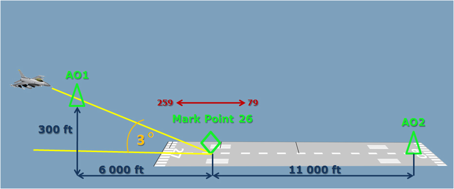
I made OA1 and OA2 points in order not to look at the HSI. I want to reduce pilot workload during landing. Instead of observing two 2D images, ILS and HSI, pilot looks only at the HUD with 3D image of the situation. Human brain with a stereoscopic vision is ten times faster processing 3D image than 2D. Our vision and brain created for hunting and always makes 3D situation image from multiple 2D images.
BTW, another advantage of the Mark Point - you can see on the HUD an accurate distance to the Threshold/Touchdown Zone.
-
… would be nice to see the same using real IMC conditions (ILS minimums visibility) and with the right approach AoA …
ASUSTeK ROG MAXIMUS X HERO / Intel Core i5-8600K (4.6 GHz) / NVIDIA GeForce RTX 3080 Ti FE 12GB / 32GB DDR4 Ballistix Elite 3200 MHz / Samsung SSD 970 EVO Plus 2TB / Be Quiet! Straight Power 11 1000W Platinum / Windows 10 Home 64-bit / HOTAS Cougar FSSB R1 (Warthog grip) / SIMPED / MFD Cougar / ViperGear ICP / SimShaker JetPad / Track IR 5 / Curved LED 27'' Monitor 1080p Samsung C27F396 / HP Reverb G2 VR Headset.
-
This post is deleted!
