ILS STEERING CUE
-
PROBLEM:
I have no steering cue in ILS mode for landing:
I Fly out of the Airbase: Seosan Korea Campaign F_16 CM-52ILS settings in Cockpit:
UFH 353.1 Tacan 052X ILS Runway 111.5 for runway 200
Tacan Switch to ILS Nav
ILS switch in on also show on in the DED.
Between 18 to 17 Miles from runway the Localizers pop up on the HUD with no steering cue!!
My speed is 350 knots at 7000
Made TE with different F-16 different airbases and still the same
But here is the kicker I flew the training mission ILS landing #4, I think
It has the f-16 block 40 at night now the steering cue in on and working great in it.
But still not working in the Campaign or TE’s
If I am doing something wrong I really don’t know what !
Please Set me Straight.
I have watched you tube Videos. I really like the one Krause put out Very Good -
Are you in NAV mode??? Press AG or AA.
-
You’re at 7000’? What was your altitude in the training mission? I suspect MUCH lower. Also, you shouldn’t be flying an approach at 350 in IFR conditions. 300 max
-
Are you referring to the command steering cue? Press 1 on the ICP, dobber right to place the scratchpad over CMD STRG, 0 to select -highlighted means that it is active.
A screenshot would help. -
There is a DED toggle for the steering cue so make sure that is on, “CMD STR” I think. Also I think you have to have the approach course set to get steering (in BMS which may or may not be realistic).
-
PROBLEM:
I have no steering cue in ILS mode for landing:
I Fly out of the Airbase: Seosan Korea Campaign F_16 CM-52ILS settings in Cockpit:
UFH 353.1 Tacan 052X ILS Runway 111.5 for runway 200
Seosan ILS is on runway 02R only.
Not every runway at every base has landing assist.
-
Seosan ILS is on runway 02R only.
This is correct.
Also if we are not on a specific “range” of altitude at specific DME (distance) from TACAN station, then we will have no ILS GS signal! For example at 4.8 NM from RWY threshold, Glide Slope has a receiving signal range of +/-400 FT over the slope altitude. Means if we are above 400 FT of the precise altitude or below 400 FT of the precise altitude then we will have no GS signal.
Obviously you were approached from the opposite RWY, with a heading of 200 deg.
Only RWY 02R has ILS at Seosan airport, with frequency of 111.50.
As you can see below at 6,000 FT MSL I have interception of ILS signal at Seosan TACAN 18 DME:

You can notice from DED that the 2 asterisks are side of “CMD STRG” and I have active the ILS steering cue.
Nikos.
-
Yes I am in the NAV mode Command steering is on and highlighted the tacan ILS points to the tacan with the course set. and the Nav ILS points to the steer point As far as altitude goes I have been as high as 15000 in TEs and it has been fine
Some Pics
-
On that last pic…the runway is at your 12 o’clock PERPENDICULAR. You’re not going to get any ILS this way. And you’ll never get it at 15k. I’ve never flown the TE training mission. The best way to do it is to learn how to use the approach plates provided in the BMS docs. Using the approach plate for that Air Base and understanding where you are in relation to the active runway, at minimum fly to the FINAL APPROACH FIX POINT and be at the altitude the plate tells you to be. That should get you closer to the glideslope and get the ILS symbology working for you to get lined up. INITIAL APPROACH FIX is to fly the arc, not sure if you’re there yet for that piece. If you’re unsure what an approach plate is or how to use it in BMS I’d be happy to teach you so you can shoot a near-perfect ILS approach.
-
No body seems to understand THERE SHOULD BE A STEERING CUE THE PIC SHOW 14 MILES OUT THERE SHOULD BE A STEERING CUE THERE IS NONE NO MATTER WHICH WAY YOU FLY
I’M DONE THANKS GUYS
-
No body seems to understand THERE SHOULD BE A STEERING CUE THE PIC SHOW 14 MILES OUT THERE SHOULD BE A STEERING CUE THERE IS NONE NO MATTER WHICH WAY YOU FLY
I’M DONE THANKS GUYS
No, there should not be. Read the manuals or train with someone who knows.
EDIT:
I offered my personal time.
-
No body seems to understand THERE SHOULD BE A STEERING CUE THE PIC SHOW 14 MILES OUT THERE SHOULD BE A STEERING CUE THERE IS NONE NO MATTER WHICH WAY YOU FLY
I’M DONE THANKS GUYS
The flight director displays command steering data on the HUD when selected on the upfront controls. Command steering symbology consists of a circle, a tic mark positioned at the top of the circle, and a reference mark/caret positioned at the heading/ground track scale. The flight director circle is referenced to the FPM and appears when localizer data is valid. Proper use of the flight director requires that the localizer be intercepted from a heading no more than 45 degrees from the localizer course using bank angles of 30 degrees or less. When the aircraft is within two dots deflection of the localizer deviation bar, the flight director commands a turn to roll out on the localizer course. The tic mark appears on the flight director circle when glide slope deviation nears center, indicating that pitch steering data is valid. The glide slope should be intercepted from a position that is wings level and on the localizer course. If the pitch steering becomes invalid, the symbol X appears over the tic mark. The reference caret indicates the heading required to maintain the course selected on the DED (magnetic heading scale displayed) or ground track error relative to the course selected (magnetic ground track scale displayed). The course value may be changed only by entering the new value through the DED.
Well, you are contradicted by the flight manual. You should only get the flight director if you have LOC signal. That only happens in a narrow swath around the approach path, I confess Im not sure how wide the LOC signal is typically.
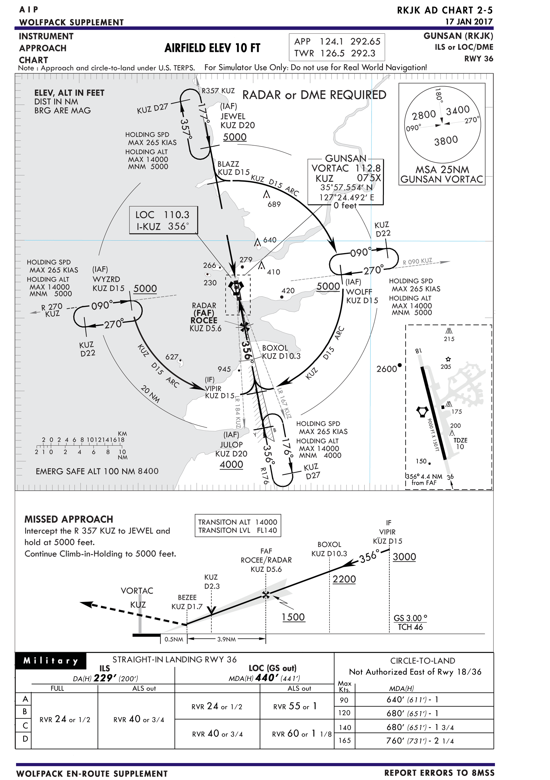
I suggest trying an approach that has you intercept the LOC first, then use that to get on the ILS. Here is one such plate:
If you are having trouble following instrument procedures generally, rather than specifically avionics difficulty, Id suggest having a read of the AFMAN11-217 volumes 1 to 3.
https://static.e-publishing.af.mil/production/1/af_a3/publication/afman11-217v1/afman11-217v1.pdf
https://static.e-publishing.af.mil/production/1/af_a3/publication/afman11-217v3/afman11-217v3.pdf
These offer a grounding in instrument flight procedures which may benefit your flying.
-
Well, you are contradicted by the flight manual. You should only get the flight director if you have LOC signal. That only happens in a narrow swath around the approach path, I confess Im not sure how wide the LOC signal is typically.
I suggest trying an approach that has you intercept the LOC first, then use that to get on the ILS. Here is one such plate:
http://images.blu3wolf.com/uploads/KAIP-RKJK-ILS-36.png
If you are having trouble following instrument procedures generally, rather than specifically avionics difficulty, Id suggest having a read of the AFMAN11-217 volumes 1 to 3.
https://static.e-publishing.af.mil/production/1/af_a3/publication/afman11-217v1/afman11-217v1.pdf
https://static.e-publishing.af.mil/production/1/af_a3/publication/afman11-217v3/afman11-217v3.pdf
These offer a grounding in instrument flight procedures which may benefit your flying.
Real life charts are not suited for BMS …
-
huh. I confess Ive had a different experience when it comes to using the performance charts for the aircraft, in BMS. But suit yourself.
Oh - if you were talking about the approach plate, thats not a real life chart. You may like to note the text at the top, warning that the chart is NOT for real navigation, only for flight simulation.
Ive adapted it from a real chart, but Ive neglected to update the spot heights. Therefore I recommend not relying on them.
-
No body seems to understand THERE SHOULD BE A STEERING CUE THE PIC SHOW 14 MILES OUT THERE SHOULD BE A STEERING CUE THERE IS NONE NO MATTER WHICH WAY YOU FLY
I’M DONE THANKS GUYS
well - sorry old boy but its YOU that doesn’t understand - you have at least to be pointing you jet in roughly the same direction as the runway heading you are trying to land on … I don’t think that’s asking too much, try it, it just might work.
Ask yourself, looking at the screenshots you posted, how the hell were you going to land on this runway with the ILS turned off ??? that I think is your answer, fly as if you can land just on visuals and then switch your ILS on … bugger me there you have it, the localiser and everything you need to land as if by magic or as if by just knowing what your doing ;0)
There are lots of people who do understand and are trying to help but “I’m done thanks guys” wont cut it with any of them - be a nice person see what happens ;0)
-
i bet he wasn’t even in the PAPA or the LOC. tacan and ILS knob, right modes, HUD, etc etc etc
100% of the time, if BMS isn’t doing something “right” its the connection between the HOTAS and the ground.
-
100% of the time, if BMS isn’t doing something “right” its the connection between the HOTAS and the ground.
Technical term: Operator Error
-
No body seems to understand THERE SHOULD BE A STEERING CUE THE PIC SHOW 14 MILES OUT THERE SHOULD BE A STEERING CUE THERE IS NONE NO MATTER WHICH WAY YOU FLY (this is wrong)
I’M DONE THANKS GUYS
Calm down my friend. There is no need to think that other guys don’t want to help you or that they don’t understand you.
Simply you don’t know well the functionality and the signal coverage of the ILS system. So let me help you understand this.
First learn that the ILS Localizer has the below signal coverage,
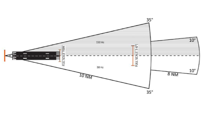
Measn into the 10 NM from the ILS Loc antenna you can have signal IF you are fly a heading with max. +/-35 deg. of the RWY heading. Into 10-18 NM from ILS Loc antenna you should be max. at +/-10 deg. of the RWY heading. Any position out of these areas and you have NO ILS Localizer signal!
The ILS Glide Slope has smaller coverage. That means that you must approach the desired RWY of the airport that has ILS with a heading close to the RWY.
And of course NOT with a heading almost vertical to it, like you had here:
If you don’t have a proper ILS signal, you can’t have a working ILS steering cue.
Try it and you will verify this. It isn’t difficult to understand it. Since you normally want to intercept the ILS outer of 10 NM, have in mind as max. variation the +/-10 deg. of the RWY heading.")
Also I remind you that you must be into a specific range of altitude in order to have also Glide Slope signal.
I hope to help you.
Nikos. -
Everything we posted/tried to explain is beautifuly explained in the BMS manuals. This is why it’s called a STUDY SIM and not a arcade game.
-

")