[F4RADAR] Lightweight standalone radar application
-
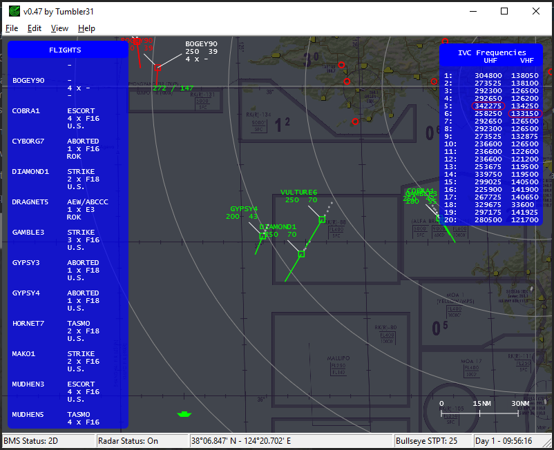
I’ve created a lightweight standalone radar application for BMS from scratch : F4RADAR. It shows all contacts spotted and gives information on the type when also identified. It shows individual planes and therefore should also be suitable for ATC, and the flights outside “the bubble”. With the right mouse button you can also draw BRAA-lines and it has the option to show a background map. It doesn’t require additional software for other players or server modifications. Do give it a try a let me know if you have suggestions or encounter bugs.
Download
You can get it ==> HERE <== on my google Drive folder.
Requirements
It should run straight from the box but formally installation of F4RADAR requires
- DirectX11 (which you are going to need for BMS anyway)
- 64bit Windows10 (feedback from Window7users is welcome)
- although already present on many systems Microsoft Visual C++ Redistributable for Visual Studio 2015, 2017 and 2019 (click link) is required. Normally only the 64x version is needed, but some reported all 3 versions, x86, x64 and arm were needed to fix the issue of “vcruntime140_1.dll is missing”.
- Windows 7 users most likely have to install Platform Update for Windows 7
IVC set-up
To have IVC working properly, some small changes are needed so everybody hear each other This is very well explained by chihirobelmo in this post. Thanks chihirobelmo!
- uncheck ‘IVC enabled’ to have the IVC client running standalone.
- the name in IVC-client should be different than your BMS name.
- pilot set set ‘outsider=all’ in your ‘IVC client.ini’ (remove # comment at the beginning of the line)
Running F4RADAR
The program does not require a specific location, nor does it have to know where you installed BMS. It is fully standalone.
-
The program has two run modes: BMS in 2D or 3D. In both cases the program will show you the radar contacts
- 3D-mode: your plane shall parked in the ramp, when you fly the program will turn-off
- 2D-mode: in the 2D campaign map view make sure the clock is running and you’re slotted into a plane, load and save the DTC to be able to cycle the bullseye STPT
-
Airfield data is provided in geometry.csv which shall be in the same folder as the program. The current provided data reflects the 4.34.4 airfield data but can be user modified
-
Contact identification information is provided in types.csv which shall be in the same folder as the program
-
Various toggle buttons and the View menu allow you to show or hide scope items
-
The options menu (Edit->Options…) allows you to configure color, sizes and control setup. The settings can be saved in the F4RADAR.ini file which will be read upon next startup. The file will be placed in the same folder as the program
-
The help menu (Help->View Help) gives brief explanation of the program and functionality
Version history:
- version 0.1 initial release (18.06.2020 )
- version 0.2 changes (25.06.2020 )
- Added the option the load and toggle a background map. Any size will do as it will be stretched to the 1024x1024km grid but I kindly suggest maps found in the WDP installation folder
- Added the option to toggle the Bullseye being shown
- Increased detection range
- version 0.3 changes (26.06.2020)
- Speedbased magnitude of heading vectors
- Decluttered info when drawing a BRAA-line and changed color for clarity
- Toggle added in view menu for display of the labels
- version 0.4 changes (04.07.2020)
- History trail for contacts
- Keyboard keys to toggle map, history, labels and bullseye
- Options for all colors, bullseye rings, vector length, history length, size of contacts, and transparency of the map
- Added the option to save preferences in .ini file, will be placed in same folder as .exe
- version 0.5 changes (12.07.2020)
- Added flights “outside the bubble”, for now both friendly and hostile show up as “bogey”
- Fixed crash when you tried to use the program whilst flying
- version 0.6 changes (20.08.2020)
- Added USA airbases and associated toggle
- Added game time in the upper right of the window
- F4RADAR now shows friendly contact below 5000ft and with the detection range
- Fixed BE cross disappearing on secondary monitor
- version 0.7 changes (20.08.2020)
- fixed game time only showing when in 3D
- added option to change color of airbases
- added a minimum detection speed for friendly contacts
- version 0.8 changes (24.09.2020)
- added callsigns outside the bubble, these contact have a trailing dash in their name
- detection range of 200NM also added to friendly AWACS
- fixed saving the minimum detection speed
- version 0.9 changes (24.09.2020)
- added the option to swap mouse button functions (default now right to pan)
- fixed detection range back to 200NM instead of 200km
- removed the trailing dash for “out of bubble” contact, as apparently this refers to NORDO.
- version 0.10 changes (05.10.2020)
- added the option to use the program when your under your parachute or dead, thus not parked on the ramp
- added statusbar with program and radar status plus game time
- fixed game time by adding days when running longer campaigns
- fixed issue of loosing connection to the 3D state of BMS
- version 0.11 changes (13.10.2020)
- added the a scrollable and moveable (click header) table showing flight info, for bogey limited to number of planes
- added support for multination war, neutral, hostile and at war are shown as bogey
- version 0.12 changes (15.10.2020)
- added contacts are now shown when spotted in BMS and plane info is given when identified in BMS, 5000ft restriction and 200NM detection limit have been removed
- added plane info in the table when contact is identified in BMS
- added latitude and longitude mouse position in the status bar
- fixed table is shown in alphabetical order
- fixed plane information in table, previous release showed wrong info for certain contacts
- version 0.13 changes (26.10.2020)
- added spotting and identifying of contacts can now also be done by allied nations
- added lat/long for all theaters in the northern-eastern hemisphere
- fixed map image for 2048x2048 theatres like POH
- table no longer shows empty flights
- version 0.14 changes (29.10.2020)
- added toggleable context menu to show detailed info at mouse over
- added yardstick
- version 0.15 changes (30.10.2020)
- fixed bug in aircraft type in context menu
- version 0.16 changes (02.11.2020)
- Added taxiways for Kunsan, Osan, Seosan, Sachon, Choongwon, Chongju, Suwon, Yechon, Mandumi, Kwangju, Hoengsong, Kangnung, Pohang, Sokcho, Taegu, Pusan, Pyongtaeg, Kimhae
- version 0.17 changes (18.11.2020)
- Added PPT and lines as visible on the HSI and stored in DTC, note that jet needs to be hot
- Added declutter option which only show flight or element name when zoomed out
- Added taxiways not plotted when zoomed out
- Implemented DirectX11 and Windows7 support
- version 0.18 changes (05.12.2020)
- Added IVC support (currently only x64 version tested)
- Added allied contacts are always shown
- Fixed errors in mission type indications
- Fixed ‘bad alloc’ crash
- version 0.19 changes (06.12.2020)
- Fixed error in spotting
- version 0.20 changes (09.12.2020)
- Added leading zero(s) at the angle indication for BE and BRAA
- Fixed program freezing for short periods
- Final version for BMS 4.34.4
- version 0.21 changes (23.12.2020)
- Updated for BMS 4.35.0
- Disabled airbases
- version 0.22 changes (29.12.2020)
- Fixed number of planes in table
- Fixed Windows7 support
- version 0.23 changes (01.01.2021)
- Fixed IVC table click still active with table not visible
- Fixed Windows7 support, for real now
- version 0.24 changes (23.01.2021)
- Added the option to change the default STPT used for the Bullseye, cycle up/down with Z/X-keys
- version 0.25 changes (30.01.2021)
- Added reading runway from .csv file
- file name should be “geometry.csv” and in the same folder as F4RADAR
- start your runway definition with “[airfield]”
- each runway should be defined as: “objective-X [km], objective-Y [km], RunwayDimPt1-X [ft], RunwayDimPt1-Y [ft], RunwayDimPt2-X [ft], RunwayDimPt2-Y [ft], RunwayDimPt3-X [ft], RunwayDimPt3-Y [ft], RunwayDimPt4-X [ft], RunwayDimPt4-Y [ft]”
- Fixed crash when cycling bullseye stpt before bullseye was loaded
- Added reading runway from .csv file
- version 0.26 changes (24.02.2021)
- Updated for BMS 4.35.1
- Reinstated 200NM/5000ft check + normal BMS spotting
- version 0.27 changes (06.03.2021)
- Changed spotting code
- Fixed mission in flight table
- version 0.28 changes (17.03.2021)
- Added option to run from 2D campaign map
- Added types.csv file to the package for contact identification
- Added ground contacts
- Changed spotting code
- version 0.29 changes (03.04.2021)
- fixed x,y-swap in custom BE-points
- version 0.30 changes (17.04.2021)
- internal fixes
- version 0.31 changes (16.05.2021)
- no functional changes
- version 0.32 changes (29.06.2021)
- Updated for BMS 4.35.2
- version 0.33 changes (30.06.2021)
- fixed incorrect slot number in flight
- version 0.34 changes (07.08.2021)
- internal fixes
- version 0.35 changes (19.10.2021)
- Updated for BMS 4.35.3
- Small fix in ground spotting
- version 0.36 changes (23.04.2022)
- Updated for BMS 4.36.0
- Added naval contacts
- version 0.37 changes (29.04.2022)
- Fixed type lookup
- version 0.38 changes (01.08.2022)
- Updated for BMS 4.36.1
- version 0.39 changes (03.08.2022)
- Fix slot number
- version 0.40 changes (27.08.2022)
- Updated for BMS 4.36.2
- version 0.41 changes (17.09.2022)
- Updated for BMS 4.36.3
- version 0.42 changes (09.01.2023)
- Updated for BMS 4.37.0
- version 0.43 changes (04.02.2023)
- Updated for BMS 4.37.1
- version 0.44 changes (19.03.2023)
- Updated for BMS 4.37.2
- version 0.45 changes (01.08.2023)
- Multi threading
- version 0.46 changes (03.08.2023)
- Fix mode switching in multiplayer
- Fix deagg velocities not shown
- version 0.47 changes (03.08.2023)
- Added dedicated naval shape
- Added the option to retry version checking
- Fix crash on certain jpg formats
- Fix BRAA/BE tool tip not begin shown
- version 0.48 changes (04.11.2023)
- Updated for BMS 4.37.3
- version 0.49 changes (28.11.2023)
- Updated for BMS 4.37.3.2
-
Very nice! You working towards some kind of GCI tool?
-
Good job! When is the private demo? :cell:
| AMD RYZEN9 5900X | ASUS RTX 4080 | G.SKILL 3200-C14 32GB | ASUS X570-E GAMING | LG 27GP850 2K/QHD |
| TM HOTAS COUGAR + MOD | VPC WARBRD BASE | MFG CROSSWIND V2 | G.TRIX JETSEAT KW908 | HP REVERB G2 | -
Dear Tumbler,
you couldn’t start your membership in this Forum better… your utility just looks interesting and promising too.
In this while, my best compliments and regards.
-
would be nice to get a version with a map and nav data waypoints, for radar approach control (human ATC potential)
-
Thanks pilot, excellent tool good job. waiting for more. Go Go Go.
---------------------------------------ACV CUBA (Ala de Combate Virtual CUBA)------------------------------------------
DISCORD
https://discord.gg/bYyxhVqxVyYOUTUBE
https://www.youtube.com/@aladecombatevirtualcuba4405 -
What would be really cool is if this could be introduced by way of actually having to be in a AWACS flight in order to use it.
-
Sounds good! …
ASUSTeK ROG MAXIMUS X HERO / Intel Core i5-8600K (4.6 GHz) / NVIDIA GeForce RTX 3080 Ti FE 12GB / 32GB DDR4 Ballistix Elite 3200 MHz / Samsung SSD 970 EVO Plus 2TB / Be Quiet! Straight Power 11 1000W Platinum / Windows 10 Home 64-bit / HOTAS Cougar FSSB R1 (Warthog grip) / SIMPED / MFD Cougar / ViperGear ICP / SimShaker JetPad / Track IR 5 / Curved LED 27'' Monitor 1080p Samsung C27F396 / HP Reverb G2 VR Headset.
-
Thanks for all the enthusiastic reactions! Yes, I hope this software can be used both for GCI applications as well as ATO.
I also got some feedback from people using it, giving me valuable inputs to improve usability and add features. One of the things that will be added for sure is the toggleable background map, also mentioned above by Blu3wolf.
So please keep that feedback coming! I can’t promise I can fix everything right away or can implement everything, but I take notice of all your points.
F4RADAR v0.49 is out, a lightweight standalone radar application. Read more here
-
Thank you for doing this, amazing
-
version 0.2 is out:
- Added the option the load and toggle a background map. Any size will do as it will be stretched to the 1024x1024km grid but I kindly suggest the 9.5MB high res version found here
- Added the option to toggle the Bullseye being shown
- Increased detection range
-
Hi! What is on your todo/roadmap for this project?
")
(Please say something with bullseye on the radar.)
-
I’ve created a lightweight standalone radar application for BMS from scratch : F4RADAR. Currently it shows all contacts within 200NM radius above 5000ft MSL. It shows individual planes and therefore should also be suitable for ATO. With the right mouse button you can also draw BRAA-lines. The only requirements are that your BMS session is in 3D and your own plane is parked on the ramp. Do give it a try a let me know if you have suggestions or encounter bugs.
It should run straight from the box but formally installation of F4RADAR requires
- DirectX (which you need for BMS anyway)
- 64bit Windows10 (feedback from Window7users is welcome)
- although present on many system Microsoft Visual C++ Redistributable for Visual Studio 2015, 2017 and 2019 (click link) can be required. Some reported all 3 versions, x86, x64 and arm were needed to fix the issue of “vcruntime140_1.dll is missing”.
Version history and changes:
-
version 0.1 initial release (18.06.2020 )
-
version 0.2 changes (25.06.2020 )
- Added the option the load and toggle a background map. Any size will do as it will be stretched to the 1024x1024km grid but I kindly suggest the 9.5MB high res version found here
- Added the option to toggle the Bullseye being shown
- Increased detection range
You can get it here on my google Drive folder.
Amazing tool, any chance we can get RWR info. some how, example if it’s a unknown F-16 it shows up as 16, similarly if it’s a J-7 it shows up as a 7 rather than 21 (I know a separate ask but wondering)
-
Tumbler,
Feature request: manual selection and visual management of identity/identified friendly and foe contacts.
manual assignment and visual management of hostile groups to be engaged by ordered/tied friendly groups.
-
Any chance of having the application run on a second pc over a network?
-
Thanks again for the suggestions and feedback here and via other channels. I hope to implement quite a few of those features. Creation of groups and visual management is on my wish list as well, but i have to admit that a networked application will require quite some effort, so don’t hold your breath.
Anyway, some features have been added, mainly to declutter the screen when plotting a BRAA line. So I’ve created version 0.3:
- Speedbased magnitude of heading vectors
- Decluttered info when drawing a BRAA-line and changed color for clarity
- Toggle added in view menu for display of the labels
The download link is in the startpost and please keep your suggestions and feedback coming!
-
Amazing tool, any chance we can get RWR info. some how, example if it’s a unknown F-16 it shows up as 16, similarly if it’s a J-7 it shows up as a 7 rather than 21 (I know a separate ask but wondering)
any one else may want to chime in, i am really going through the sim folder and radar.dat files but can’t make a link of where the rwr symbology is being driven from. It seems like there is an index but no actuall mapping, like how does a mig-21 shows up as 21?
-
Just released v0.4 which should include nearly all features you would expect from the GUI. Version 0.4 has these changes (04.07.2020):
- History trail for contacts
- Keyboard keys to toggle map, history, labels and bullseye
- Options for all colors, bullseye rings, vector length, history length, size of contacts, and transparency of the map
- Added the option to save preferences in .ini file, will be placed in same folder as .exe
Next I’ll try to add more features to the tool itself. Adding aircraft type can be one of them but I’d like to do so with some sort of fog of war implemented.
I also got the feedback that some bogey disappear for a few sweeps and than pop up again. I can’t really see how that should happen, but if you experience it, do let me know and info on the situation (altitude, speed, distance, etc) would greatly help.
-
Version v0.5 is out, thanks Eagle-Eye for the help and also other for providing me with feedback. This version now also sees contacts outside the 3D bubble but has it limitations. Enjoy it while you can!
Version 0.5 changes (12.07.2020)
- Added flights “outside the bubble”, for now both friendly and hostile show up as “bogey”
- Fixed crash when you tried to use the program whilst flying
-
I’ve created a lightweight standalone radar application for BMS from scratch : F4RADAR. Currently it shows all contacts within 200NM radius above 5000ft MSL. It shows individual planes and therefore should also be suitable for ATC, and the flights outside “the bubble”. With the right mouse button you can also draw BRAA-lines and it has the option to show a background map. It doesn’t require additional software for other players or server modifications. The only requirements are that your BMS session is in 3D and your own plane is parked on the ramp. Do give it a try a let me know if you have suggestions or encounter bugs.
It should run straight from the box but formally installation of F4RADAR requires
- DirectX (which you need for BMS anyway)
- 64bit Windows10 (feedback from Window7users is welcome)
- although already present on many system Microsoft Visual C++ Redistributable for Visual Studio 2015, 2017 and 2019 (click link) is required. Normally only the 64x version is needed, but some reported all 3 versions, x86, x64 and arm were needed to fix the issue of “vcruntime140_1.dll is missing”.
Version history and changes:
-
version 0.1 initial release (18.06.2020 )
-
version 0.2 changes (25.06.2020 )
- Added the option the load and toggle a background map. Any size will do as it will be stretched to the 1024x1024km grid but I kindly suggest the 9.5MB high res version found here
- Added the option to toggle the Bullseye being shown
- Increased detection range
-
version 0.3 changes (26.06.2020)
- Speedbased magnitude of heading vectors
- Decluttered info when drawing a BRAA-line and changed color for clarity
- Toggle added in view menu for display of the labels
-
version 0.4 changes (04.07.2020)
- History trail for contacts
- Keyboard keys to toggle map, history, labels and bullseye
- Options for all colors, bullseye rings, vector length, history length, size of contacts, and transparency of the map
- Added the option to save preferences in .ini file, will be placed in same folder as .exe
-
version 0.5 changes (12.07.2020)
- Added flights “outside the bubble”, for now both friendly and hostile show up as “bogey”
- Fixed crash when you tried to use the program whilst flying
You can get it here on my google Drive folder.
Does it butt-hurt more, if you use “god-mode” apps on public servers, and still get your arse whooped?
As “home-boy cockpit-builder” fancy those apps might be… (and fun to code them), do they not defeat the purpose of “what the battlefield is supposed to be” - native , for all sides - including the “hidden” and “pop-up” surprises of a battlefield (air or ground)?
If i fail to get my point accross… imagine playing COD and the other team has a 3rd party app on 2nd screen “seeing everyone, everywhere, all the time” … - well in this case exception under 5000 feet lol.