Tiles from highest res sat map, makes this sence?
-
Yes, that is logical.
I think I was irritated because of the “zooms”, the deeper you are flying the greater the zoom. So, if you already have a high res, that will increase ².
I think I restart the project and take the “20 m map”…
Any idea about 1,3 to 1 (e.g., or 1,2), meaning 1,3 km in RL = 1 tile? Would this be too unreal? -
I think it would be misguided, in my opinion. I think you would be better off keep the correct scale, and getting higher resolution data to aid the correct sense of scale. Being able to add more features would assist greatly in this.
-
In Falcon: 1 tile = 1² km. This is good scale.
-
But 1024 pixels.
For sense of speed what is actually needed is variation and vertical patterns.
Those patterns must be distinctive. For city tiles I don’t think there is need for sense of speed pattern but crisp clear detailed tiles.
HDR and sharpening I believe give good results.HOT LIST

System Specs:
i7-2600K @ 4.8 Ghz WaterCooled / 32GB Ram. 128GB SSD/1TB SSD / GTX1080Ti 11GB DDR5X / HOTAS COUGAR. TrackIR 4 / 3x24" Mon. (res:5760x1200) / Cougar MFD's / Wheel Pedals / Win 10 64 bit.

-
Arty,
No matter how many pixels. The scale is in kilometers (or miles) not texture resolution. -
Hmmm so your tiles In 512 resolution will look ok?
Even 1024 is low. (?)HOT LIST
System Specs:
i7-2600K @ 4.8 Ghz WaterCooled / 32GB Ram. 128GB SSD/1TB SSD / GTX1080Ti 11GB DDR5X / HOTAS COUGAR. TrackIR 4 / 3x24" Mon. (res:5760x1200) / Cougar MFD's / Wheel Pedals / Win 10 64 bit.
-
Arty,
Earlybite asked whether 1.3 or 1.2 kilometer scale is ok for one tile.
I said - one tile is 1 km. We are talking about the scale of terrain, not a textures resolution (quality). Of course the higher resolution is better. But please do not confuse pixels with km. -
Eghi he didn’t ask just for scale. Read his first post please. He is mentioning resolution.
Now as you say and he wonders 1024 pixels in a tile per side are 1 pixel one meter so going 1 pixel to 1.3 meters u scale and u sacrifice detail at the same time.
Don’t really know the impact of going 2048x2048 but it would certainly be way better.This test could be made short of easily just pump those dds’s to 2048x2048 and give it a spin. The fps load will be very close to dds tiles created just with 2048x2048 in mind.
HOT LIST
System Specs:
i7-2600K @ 4.8 Ghz WaterCooled / 32GB Ram. 128GB SSD/1TB SSD / GTX1080Ti 11GB DDR5X / HOTAS COUGAR. TrackIR 4 / 3x24" Mon. (res:5760x1200) / Cougar MFD's / Wheel Pedals / Win 10 64 bit.
-
Arty, scale IS resolution.
Whether you are talking resolution of meters to tiles, or pixels to tiles… its resolution.
-
1,3:1 (1,3 km in RL = 1 km in BMS = 1 tile) has the thought, that houses will rush over faster.
I’m just at the project and will make a test how the a/c looks e.g “on” this roof.
20m sat map:
The F-16 has a length of ~16m and this building ~50m, so the A7c should fit three times into, isn’t it? Even at ~300fts…Oh, and BTW:
These range brackets of a sat map (10m, 20m,…), are they giving the range inside itself, or outside? -
The texture resolution will be a good visual improvement. More pixels in the same space will be reflected as more detail. As you increase texture resolution (1024->2048->4096) the more sharp will be in low level. For the sense of speed all is needed is ladscape details, more buildings, more trees, etc. There is another point to take into account. The sense of altitude (and distance in general); this is obtained via color saturation.
Many of these techniques are well explained and coded here
-
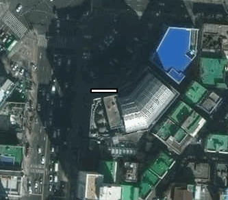
Here a test…, this silver-building has a length of ~50m and the F-16 ~16m.
Inside:
From the “hat key”:
And “hat key” with ‘l’:
(This is a tile from a map where 20m = 90px inserted in a 45004500 picture, reduced to a 20482048 dds-file…)
IMO, I had a fault in my thoughts.
1 km is 1 km and only the details will change by changing the map res.
And it seems, that ~300fts and ~150fts is a different like day and night in sense of speed, dependent of FOV (actually I’m using 75).[1] Leaning back (with Trak-IR I can get FOV = 80) the sense of speed is increasing heaviy.
Changing e.g. 1:1 to 1,3:1 (RL to tile) would IMO increase sense of speed, but would reduce the scaling (buildings woud appear a little smaller). Here the question is: Do I want to have the “real” scaling, or the better sense of speed…[1] Just flew at an alt of ~150fts and the buildings rushed just so over. No way to really check (IMO).
Now I’m thinking, that I can go on with my existing settings…
(Ah, still the question: Are those range brackets on a sat map showing the range inside this brackets, or outside? (Thanks.))Greeting
Earlybite -
Your question doesnt make any sense…. what do you mean by range inside or range outside??
Do keep in mind that your effective FOV will change the sense of speed far more than anything else…
If you zoom in, so that your monitors actual FOV is the same as the simulators provided FOV, you will get a MUCH higher sense of speed.
To see what I mean, switch to the HUD only view (press ‘1’) and fly at low level…
-
The sense of speed for me is good now. What will make you feel the speed better is the peripheral vision so using 3 monitors or ultrawide monitors will help. What I really lack is the sense of altitude, but this is another story…
-
Higher detail terrain would really help that one.
I noted that FSX has a good sense of altitude and speed, so I did a flight from Kunsan to Seosan twice - once in FSX flying an Evektor Sportstar, and once in BMS flying a block 40.
FSX had a good sense of altitude, and speed. My god the Sportstar is slow compared to the Viper! It took me 53 minutes to do it in FSX… it took 7 in BMS, and I was NOT in a hurry either!
Flying it in BMS, I could see SOME of the terrain details from FSX, but not very many… FSX has a lot of small hills along the coast between the two bases. The weather was also a lot more interesting.
BMS was a lot flatter obviously, and with less terrain detail.
The thing that surprised me the most was the airbases though! BMS kicks the shit out of FSX’ default airbases it seems. Kunsan had a couple buildings, but mostly it was just flat taxiways, mostly in the right spot.
Haemi on the other hand, was two parallel runways… and NOTHING ELSE. No taxiways, no buildings, nothing…
-
Earlybite,
for a correct scaling I would land there and park next to a car. Look from above and 4 and a half car should be the length of the F16.
Being too far from an object (like flying over the building is not precise because of the FOV dependency).
Perhaps someone has a better idea? -
Your question doesnt make any sense…. what do you mean by range inside or range outside??
Bing maps do not have brackets for the range (e.g. 20m, 50m, etc.). But Google maps has and also Here maps. And especially Here maps has great brackets. When I take the pixels (e.g. 40px = 10m) I do not know if I get the px from inside the bracket, or from outside.
The reason is, that I still do not know from which map I shall take the pictures, Bing, Google, Here (, any others?).
In my understanding I could use all of them, because it will not be a commercial using, even by sharing here… -
Well-
I think: yes! absolutely. But not for all Areas. For Long, boring fields, Woods and sea is 512x512 or less good enough. But for higly detailed Areas just like airfields, towns, habours and villages it should be highly detailed and big.
I thought about 4096x4096 textures for Airfields. So there is a Chance to work without 3ds run/Taxiways. You Need less RAM for 3d and runway textures- have realistic Details and the runways can follow the Terrain … ist just an idea. I nevver tested it.
Cheers
Tom -
Earlybite,
for a correct scaling I would land there and park next to a car. Look from above and 4 and a half car should be the length of the F16.
Being too far from an object (like flying over the building is not precise because of the FOV dependency).
Perhaps someone has a better idea?On which highway?
-
Higher detail terrain would really help that one.
I noted that FSX has a good sense of altitude and speed, so I did a flight from Kunsan to Seosan twice - once in FSX flying an Evektor Sportstar, and once in BMS flying a block 40.
FSX had a good sense of altitude, and speed. My god the Sportstar is slow compared to the Viper! It took me 53 minutes to do it in FSX… it took 7 in BMS, and I was NOT in a hurry either!
Flying it in BMS, I could see SOME of the terrain details from FSX, but not very many… FSX has a lot of small hills along the coast between the two bases. The weather was also a lot more interesting.
BMS was a lot flatter obviously, and with less terrain detail.
The thing that surprised me the most was the airbases though! BMS kicks the shit out of FSX’ default airbases it seems. Kunsan had a couple buildings, but mostly it was just flat taxiways, mostly in the right spot.
Haemi on the other hand, was two parallel runways… and NOTHING ELSE. No taxiways, no buildings, nothing…
The real sense of altitude is missing even in FSX and Prepar3D. Maybe X-plane 10 has better (never tested myself). What I can see is google earth, try the option “Use photorealistic rendering”.