Pusan RWY 14
-
I think that you misunderstood something here. You said “and like you say the localizer needs to be intercepted at 16nm out.” but that is not correct at all.
The specific words are ONLY for the specific procedure of ILS to RWY 01 of Bandirma airbase in Aegean theater!
Please keep in mind that each one procedure is unique. Of course the methodology is the same, but you don’t always have exactly the same DME, the same altitude and the same final course in all procedures.
See below the ILS approach procedure to RWY 03 of Aviano airbase:
http://i8.photobucket.com/albums/a40/neystratiou/Aviano_ILS_final.jpgHere you can see that we intercept the Localizer and the Glideslope course at 9 DME after a right turn exiting the 11 DME arc.
Nikos.Ok i have some questions,
How do i know what heading i need to be on before the right turn at DME 11? so for example i’m coming in to land and i’m 30nm away. I’ve entered the TACAN and ILS info for Aviano RWY 03 on my DED, and selected TCN/ILS on mode selector next to HSI. Do i then follow the station pointer arrow on the HSI so its at my 12 o’clock? and will my heading once i’m on that arrow be 150 degrees? (from what i can make out on that chart) then just wait till i’m 11 miles out with CDI showing at 6 o’clock to my ownship? then turn right, but how many degrees do i bank?
Also on that chart, how can i tell where i intercept the localizer and glidescope? you say i intercept both at 9 DME but theres’ nothing saying that. On the chart for Bandirma above also, theres’ nothing saying the localizer is intercepted at 16 DME and glidescope at 9.8.
Also noticed both charts are different in that Bandirma is just for the ILS approach where for Aviano it has TACAN and ILS.
-
Ok i have some questions,
How do i know what heading i need to be on before the right turn at DME 11? so for example i’m coming in to land and i’m 30nm away. I’ve entered the TACAN and ILS info for Aviano RWY 03 on my DED, and selected TCN/ILS on mode selector next to HSI. Do i then follow the station pointer arrow on the HSI so its at my 12 o’clock? and will my heading once i’m on that arrow be 150 degrees? (from what i can make out on that chart) then just wait till i’m 11 miles out with CDI showing at 6 o’clock to my ownship? then turn right, but how many degrees do i bank?
Also on that chart, how can i tell where i intercept the localizer and glidescope? you say i intercept both at 9 DME but theres’ nothing saying that. On the chart for Bandirma above also, theres’ nothing saying the localizer is intercepted at 16 DME and glidescope at 9.8.
Also noticed both charts are different in that Bandirma is just for the ILS approach where for Aviano it has TACAN and ILS.
O.k. i will try to help you a little more. But you must study, without knowledge don’t expect to can be able to understand as also to execute these procedures ;).
Don’t get it wrong, no offending here. I just see that you don’t know the basics, only that.
So here we are:
First you approach to the NavAid station (TACAN) of the desired airport if it hasn’t a published arrival chart while watching for near traffic and then you can execute the published approach procedure that maybe has, like Aviano ILS to RWY 03.
Crossing Aviano TACAN (ID AVI), you follow the TACAN radial 150 outbound with heading of 150 deg. and at 5,000 FT (with local QNH). That means that at your HSI you should have the bearing at 6 o’clock and the pointer of CDI arrow to 12 o’clock with the course to show 150.
Then when you cross the 9 DME (and still be on R-150 at 5,000 FT) you make a right turn with IAS 250 KTS and bank 30 deg. (see at Balkans MAIP page 4 - paragraph 2 “Turns”) at the same time that you descend with 147 FT/NM (or 1.4 deg.). You keep your turn until to see the bearing triangle at the HSI to be exactly at 3 o’clock, then you are joining the 11 DME arc. Then you manage to keep the pointer there (at 3 o’clock) and continue your descent with the same gradient. You set at your HSI as course the 197 that is the Lead Radial (LR-) and when you cross that radial (check at HSI to see the CDI centered) then you start your right turn again with IAS 250 KTS and bank 30 deg. When your heading be 030 deg. you should normally be on Localizer course (or very little offset) at 9 DME and very close to 3,040 FT. You also be on Glideslope, means that both ILS lines are centered now and then you can continue your ILS final approach to RWY 03…
Now check this zoomed portion of the map to see the specific signs of Localizer and Glideslope
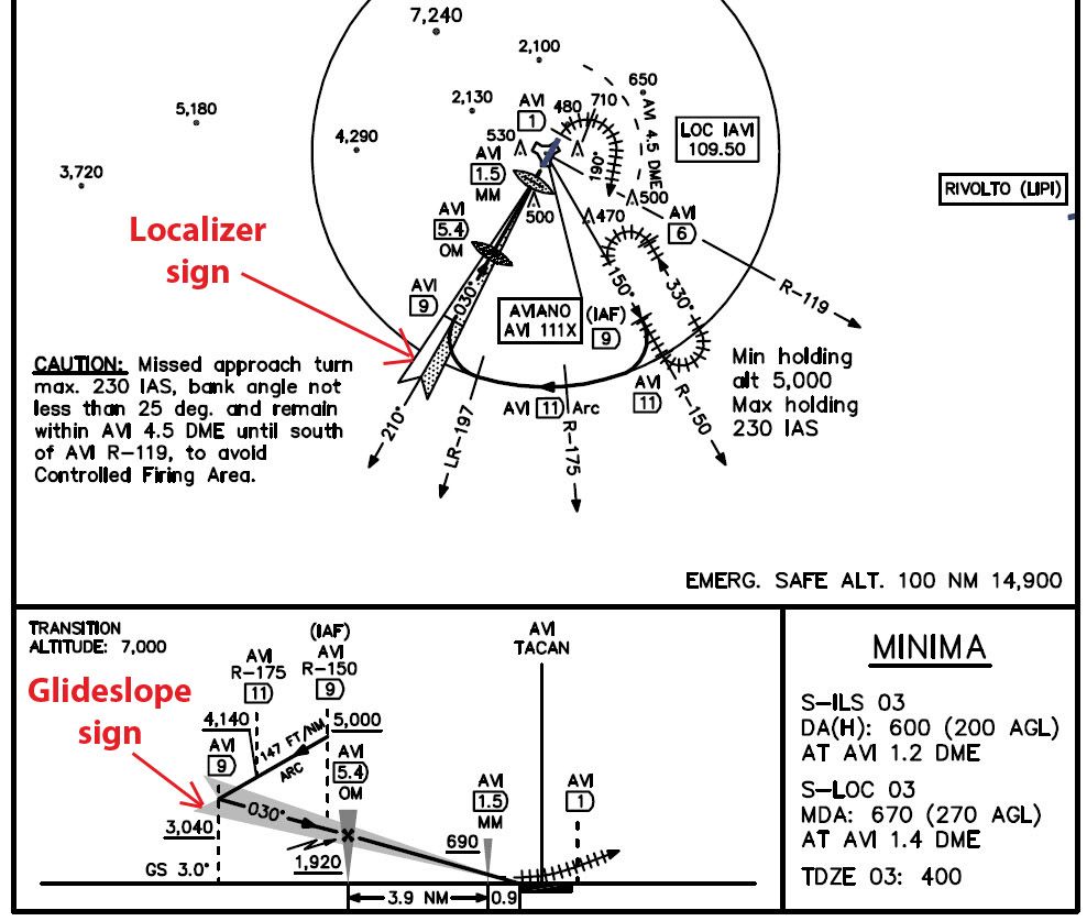
So since you know which sign means and represent what, then it is very easy to understand where the fligh path intercepts them.
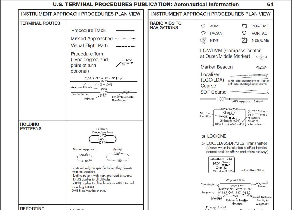
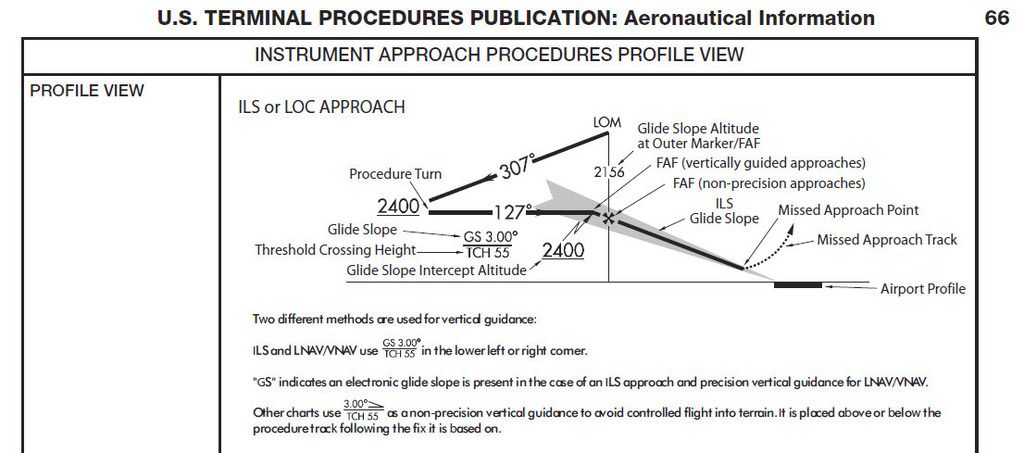
Check the below photos to get some ideas about them:
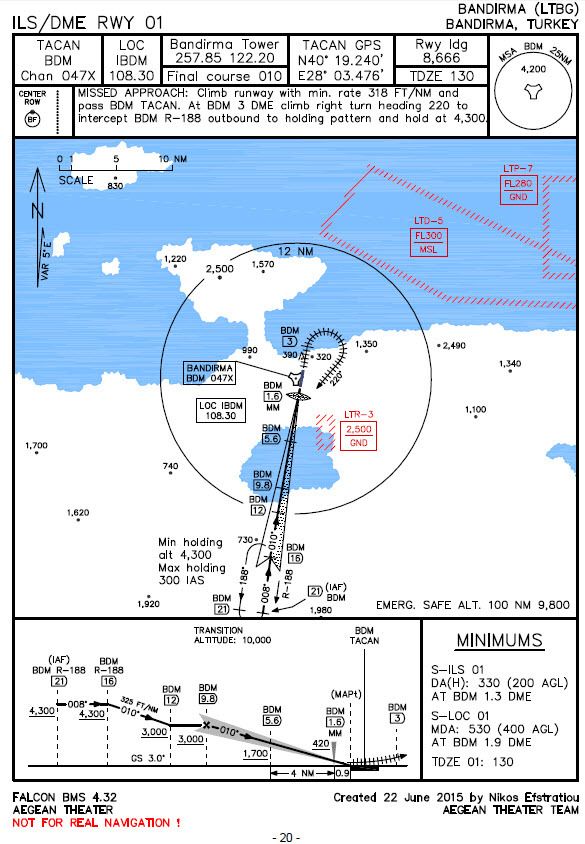
Finally now it is obvious where at the ILS approach to Bandirma airbase is the interception of Localizer and Glideslope. Simply you study the chart and you can then very easily spot that points.
Also check the complete chart of Bandirma ILS approach to see that it also has a TACAN station:
I hope to help you.
Nikos. -
O.k. i will try to help you a little more. But you must study, without knowledge don’t expect to can be able to understand as also to execute these procedures ;).
Don’t get it wrong, no offending here. I just see that you don’t know the basics, only that.
So here we are:
First you approach to the NavAid station (TACAN) of the desired airport if it hasn’t a published arrival chart while watching for near traffic and then you can execute the published approach procedure that maybe has, like Aviano ILS to RWY 03.
Crossing Aviano TACAN (ID AVI), you follow the TACAN radial 150 outbound with heading of 150 deg. and at 5,000 FT (with local QNH). That means that at your HSI you should have the bearing at 6 o’clock and the pointer of CDI arrow to 12 o’clock with the course to show 150.
Then when you cross the 9 DME (and still be on R-150 at 5,000 FT) you make a right turn with IAS 250 KTS and bank 30 deg. (see at Balkans MAIP page 4 - paragraph 2 “Turns”) at the same time that you descend with 147 FT/NM (or 1.4 deg.). You keep your turn until to see the bearing triangle at the HSI to be exactly at 3 o’clock, then you are joining the 11 DME arc. Then you manage to keep the pointer there (at 3 o’clock) and continue your descent with the same gradient. You set at your HSI as course the 197 that is the Lead Radial (LR-) and when you cross that radial (check at HSI to see the CDI centered) then you start your right turn again with IAS 250 KTS and bank 30 deg. When your heading be 030 deg. you should normally be on Localizer course (or very little offset) at 9 DME and very close to 3,040 FT. You also be on Glideslope, means that both ILS lines are centered now and then you can continue your ILS final approach to RWY 03…
Now check this zoomed portion of the map to see the specific signs of Localizer and Glideslope
http://i8.photobucket.com/albums/a40/neystratiou/LIPA_zoomed.jpgSo since you know which sign means and represent what, then it is very easy to understand where the fligh path intercepts them.
Check the below photos to get some ideas about them:
http://i8.photobucket.com/albums/a40/neystratiou/Procedures_64.jpghttp://i8.photobucket.com/albums/a40/neystratiou/Procedures_66.jpg
Finally now it is obvious where at the ILS approach to Bandirma airbase is the interception of Localizer and Glideslope. Simply you study the chart and you can then very easily spot that points.
Also check the complete chart of Bandirma ILS approach to see that it also has a TACAN station:
http://i8.photobucket.com/albums/a40/neystratiou/LTBG_full.jpgI hope to help you.
Nikos.Thanks this has helped a lot, also watching the TACAN and ILS approach videos has too.
-
Since this post is about Pusan TACAN RWY 14 approach this seems an appropriate place to post. I’m not sure if I’ve found a couple of mistakes on the chart for this approach. Namely the following…
- The chart shows a MSA of 5100ft north of the TACAN, yet the 11 DME arc instruct you to descend to 2000ft. Between KOVIC (IAF) and 11 DME R320 there are a couple of mountains around 2000ft and 3000ft high respectively.
- The descent profile bottom of the chart shows to fly heading 140 from KOVIC (IAF) which I believe should read 320 and it also shows to fly heading 320 at DME 7 on the final approach. I believe this should read 140. The two seem to be the wrong way around.
Hello my friend.
Well I just checked the procedure, and I can tell you these:- About 1 remark, it is usual to see this, means an MSA altitude above of some section of the flight track. Since the department (in BMS the creator) checked and confirmed the procedure, it is fine that. The MSA stands for the case that you will be off track for any reason (into the range of 25 NM from the NavAid - in our case the Pusan TACAN) and then you must climb to that safe altitude the sooner practicable!
Also I flew all the Pusan TACAN 11 DME arc and there is no case of dangerous obstacles like you mentioned. The most high were at Pusan TACAN R-347/11 DME with 1,750 FT MSL and then at Pusan TACAN R-015/11 DME with 1,410 FT MSL. But R-347/11 DME is 5.2 NM away (flight track) of the R-320/11 DME, means a safe distance for be at 2,000 FT MSL. The specific arc has 4,000 FT altitude difference and 17.3 NM flight track. This gives a constant descent of 231.2 FT/NM, means to be at R-347/11 DME at 3,205 FT MSL (with obstacle altitude of 1,750 FT MSL).
Something went wrong at your measurement. Please check again. - About 2 remark, at the portion of the arcs we don’t have headings. But since Red Dog adds, I guess that he wants to place emphasis at the starting and exiting heading. With this in mind yes, at IAF KOVIC should be 320 and at R-320/11 DME should be 230 deg. as an exiting heading of the 11 DME arc (this is correct).
Last at R-320/7 DME should be 140 deg. for sure, since we are inbound on Radial 320 to Pusan TACAN.
Nikos.
-
Hi Nikos,
Thanks for your reply. I flew the approach again and paid very close attention to the DME whilst flying the arc and I can see that you are indeed correct. The terrain obstacles are in fact not a problem. My original assessment was incorrect. Thanks for pointing this out. It also helped taking a more gentle descent from 6000’ at KOVIC to 2000’ at DME11/R320 rather than rushing to get to 2000’ as i did previously. Thanks.
You are welcome dear friend ;).
Nikos.
