Tacview – Understand what happened during your last flight! (alternative ACMI viewer)
-
Sorry, on vacation, not home for a month or so. All I can say is that when I set the limit to 100MB, TacView often winds up loading it forever until I click on it, at which point it crashes. However, the main issue I wanted to raise was the long times it takes for BMS to process the .vhs files, which I now understand can’t be avoided.
-
Found a minor issue in 1.3.3:
dropping BLU’s in low level TacView counted them as they had hit me.
-
Yes, this misjudgment is hard to avoid with the information available… You should see less of this kind in Tacview 2.0.
Thanks for the feedback!
-
Tacview 1.3.4 is available!
I was quite busy during the past months, so this version is only a step towards Tacview 2.0. Nevertheless, several of your suggestions have been implemented and you can also enjoy improved ergonomics, especially during network sessions analysis.
The next step is the v1.4 with the first version of the famous online debriefing and native support for X-Plane.
Don’t worry, Tacview 2.0 is still on its way and planned to be released as soon as possible.
Vyrtuoz
http://www.strasoftware.com/download/tacview
FEATURES & CHANGES
- Added combined roll angle and G force display to the HUD
- Added support for DCS World Nevada Terrain
- Added support for the Hawk T.1A (DCS World)
- Improved 3D view labels readability
- Selected object labels are now displayed in foreground
- Missiles acceleration (Gs) is now displayed as lateral acceleration instead of total acceleration
- Inactive objects are now greyed out in the selection lists
- Increased Falcon 4.0 DTC lineSTPT objects height from about 10,000 feet to about 30,000 feet
- Unknown Falcon 4.0 DTC PPT types are now displayed with a height equal to their radius
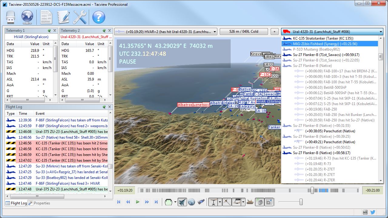
- Relative spawn time is now displayed for each aircraft in the objects lists
- Weapons fire time is now displayed in relative time to mission start in the objects lists
- Added Line of Sight Rate telemetry between selected objects
- Added support for Hebrew characters in the 3D view
- It is now possible to display an empty terrain for best readability
- Automatic declutter is less aggressive when auto-scale up is not active
- Tacview now automatically checks and notifies when a new version is available for download
- Updated Aegean Theatre for BMS to v1.5
- Tacview now also loads static objects from the %USERPROFILE%\Saved Games\Tacview\Data\Static Objects\ folder
- Added a mini crash reporter to help with crashes analysis
FIXES
- Multiple instances of the same player aircraft are now properly grouped and sorted in the objects list
- Temporarily disabled textures streaming to fix crashes with some graphic cards
- Uninitialized memory was triggering random crashes with some graphic cards with the free edition of Tacview
- Time slider was not moving properly when clicking before or after the slider
- Tankers (ships) were displayed as KC-10 Extender (the aircraft)
- Clicking on objects list without any flight data loaded was making the application crash
- Fixed rare crashes in charts and 3D view while working with invalid telemetry values
- An error message about FSX2ACMI.exe was displayed in some cases when uninstalling Tacview
- The export script for DCS World is now resilient to multiple references to fix performances issues when wrongly installed
-
Many thanks for your efforts Vyrtuoz! Keep up the good work!

-
Thanks vyrtuoz for your on-going support
")
-
This stuff is just great !!! and yes I bought into it :0)
-
Hey Vyrtuoz,
I’ve just noticed a problem with TacView 1.3.4. It might have already existed in previous versions, but I didn’t check.
When playing back a BMS .vhs/.acmi, the coordinates displayed in the upper left-hand corner of the main screen do not match the in-game coordinates.
For example, I have created an in-game precision steerpoint of N37°08.128 E130°20.589 and I’m dropping a JDAM on that location (which happens to be the central Target 7 on KOTAR range). When viewing the recording with TacView, one can see that the bomb hits the target precisely, but that the last coordinates of the bomb during its lifetime are displayed as N37°05.19959 E128°53.67608.
It appears as if TacView is somehow correcting the not-true-to-real-life WGS84 coordinates of the Falcon world into closer-to-real-life coordinates, which are obviously not very helpful in the context of evaluating virtual flights.
Is there a way to make TacView display the actual in-game coordinates of objects?
-
This post is deleted! -
You are right Bestandskraft: this difference is because I’ve tried to correct as much as possible Falcon 4 map projection to match reality.
That said I understand perfectly your concern. You can try to correct the coordinates by yourself by changing the bounding latitude/longitude of the Korean map which is declared in C:\Program Files (x86)\Stra Software\Tacview\Data\Xml\Data-Falcon4Theaters.xml
Please have a look at the corresponding documentation: http://tacview.strasoftware.com/documentation/falcon/
If someone knows the exact bound coordinates of Falcon 4 Korea map (or any other maps), do not hesitate to let me know, I will gladly include them by default in Tacview declaration file. I understand that reproducing accurately flight from Falcon 4 is more important than trying to stick to real world map coordinates in that case…
-
Unfortunately changing the bounding lat/long cannot result in a good solution.
I’m not a map maker, but based on my limited knowledge of how the Falcon map projection system works, only the lower-left coordinates of any terrain are defined in a file. To obtain these coordinates, I’m aware of two methods:
- Use Terrain Editor (http://sakgiok.gr/downloads), specifically its “Map Editor”. Lower-left longitude and latitude will be displayed in the upper right-hand corner.
- Use F4AWACS (part of Online Squadron collection, also found at the above link), and import a theater. You can then view the lower-left coordinates under Theaters - Modify Theaters - Edit…
For Korea, these coordinates are N33.84375°, W123°. While the uppermost latitude is fairly easily determined with Terrain Editor (not in mathematically precise way though), and for Korea BMS seems to be 43.04002, the easternmost coordinate depends on latitude, and is approximately 135.582553 in the north and 134.072419 in the south. Therefore, entering a fixed value in the .xml file will still result in inaccurate coordinates.
I tried modifying the .xml anyway with the above figures, and the only change I noticed was the software transposing the lines/objects to a physically different (and way off) location on the map, while the displayed coordinates of the bomb at impact were still the same.
Some formulas underlying the F4 map projection are found at https://www.benchmarksims.org/forum/showthread.php?19693-converting-x-and-y-values-into-lat-and-long.
Maybe it would be possible to change the TacView code to incorporate these formulae. Based on personal testing, the game uses 3.27998 ft in one meter to convert its X/Y coordinates to feet, and not the SI-conversion with 3.280839895 (= 1/0.3048) ft per meter though.
-
Thank you. I will have a look at this as soon as I have the time.
Meanwhile, remember that you must reimport the original vhs file (not the acmi file) to take into account the new coordinates.
-
Unless “reimporting the original vhs file” means something else than double-clicking on the original .vhs recording of my KOTAR flight to be replayed on TacView, doing so results in the same (wrong) coordinates displayed regardless of whether the original or the modified boundary coordinates are set in the .xml. Converting the .vhs to .acmi does not change this.
Anyway, great you’re looking into the issue.
-
(Didn’t have the chance to look at it yet)
When you open the vhs file from Tacview, make sure you are using the right Korea theater (see the theaters list in the file-open dialog-box). Also, make sure you are changing the BMS Korea parameters (or in the worst case both Korea theaters) in the xml file.
-
Interesting:
With only the “Falcon 4.BMS” theater’s boundaries adjusted in the .xml, even when explicitly selecting the “Falcon BMS” theater in TacView (and also when deliberately selecting the “Falcon 4.0 / Allied Force” theater), the program will display the “wrong” coordinates.
However, when adjusting both the “Falcon 4.BMS” boundaries AND the “Falcon 4” boundaries (I had previously only adjusted the “Falcon 4.BMS” boundaries), regardless of whether “Auto” terrain or either of the “Falcon BMS” and “Falcon 4.0 / Allied Force” theaters are selected, the displayed coordinates are much closer to the actual in-game coordinates. The only problem is that in this case, all default objects, such as the pre-made red KOTAR objects/targets and airports, are now physically at the wrong location (much further west).
Thus, with the following values…
<west>123</west>
<east>134.535600</east>
<south>33.84375</south>
<north>43.04002</north>…134.535600 being the maximum longitude at the latitude of the impact point calculated using the formulae linked above, I’m getting an impact point of N37°08.12972 E130°20.59026, versus the “correct” one of N37°08.128 E130°20.589. The very small error is probably attributable to rounding.
I strongly suspect that if you get in touch with the BMS developers, they can provide you with the mathematically correct constants and rounding methods (if any) that allow you to code TacView to always display the 100% correct in-game coordinates.
-
Tacview 1.4 beta 1 is now available to registered users!
http://www.strasoftware.com/beta/tacview/
While still working on the online debriefing and the real-time flight recording, I want to release this new version which offers a lot of little improvements for everyone. Whether you are using Tacview for real-life or virtual combat, I’m sure each of you will find something neat in this new version!
FEATURES & CHANGES
- Added support for Garmin G1000 Flight Deck CSV files
- Added support for KML flight recordings exported from ForeFlight & FlightAware
- Added support for MGRS coordinates system
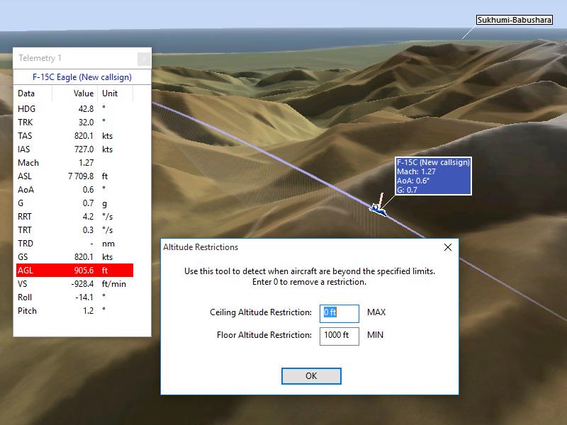
- Added AGL (above ground level altitude) to charts, labels & walls
- Added roll and pitch angles to the telemetry windows
- You can now define AGL & ASL restrictions which trigger alarms
- Clicking the compass now returns to a top view with the north up
- Labels size and auto-scale can now be automatically or manually adjusted to match screen resolution
- New versions of Tacview will be installed on previously installed versions
- Improved fonts used in the 3D view and charts
- Added support for Windows 10
- Terrain, static objects, and 3D models can now be stored in %USERPROFILE%\Saved Games\Tacview\Data\
- Added DA40 Diamond Star 3D mesh
- Added some real world airports to the map
-
Very very nice, thank you!
")
-
By the way, I didn’t forget you Bestandskraft. I’m currently busy on a big task, so I will check theses coordinates later. Thanks for the research!
-
Hi Vyrtuoz,
You are doing a great job with tacview! Every version with much new features. Many thanks!
Can’t wait for your new improvement with the online debriefing!")
regards,
Eagle -
Man, man, man,
The new CTRL+C and CTRL+V function in Tacview is a true piece of brilliant work!!!
Liking it!
Suggestion: Does any future version come with a dedicated listing of all saved bookmarks in the acmi?
Thanks and keep up the good work!
Cheers,
Scub