Tacview – Understand what happened during your last flight! (alternative ACMI viewer)
-
Thanks for the heads-up, that did it. I usually open ACMI files by double-clicking, and I don’t seem to recall being able to select the proper theater then, also selecting the terrain from the menu didn’t change anything.
Using the “Load ACMI” menu entry, everything appears to work fine (1.5.2)
cheers, Uwe
System specs: win10pro / Linux Mint 21.x, 32GB RAM, RTX3070, 2x1 TB SSD, 1x2TB NVMe, 1x4TB SATA; HOTAS Warthog Stick(DX), WinWing Orion2 Throttle w/ f16 grip, TM MFDs, CH Pro Flight Pedals w/ custom USB controller; CPU: AMD Ryzen 7 3700X 8-Core; MoBo: X570-A PRO (MS-7C37); Display: 42" LG Nano 42 (2560x1440), 19" Fujitsu-Siemens (1280x1024) used for DE /w YAME64 beta; DelanClip /w PS Eye, opentrack; GameTrix JetSeat /w SimShaker Wings; Stream Deck XL (32 buttons) as ICP
-
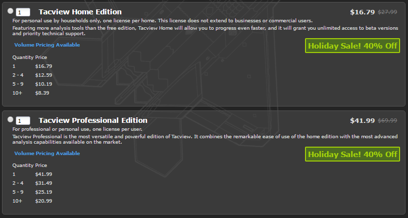
Tacview holiday sale has started!
From Dec 21st to Jan 4th, 40% off on all Tacview licenses including group buy.
If you want to upgrade you Home edition to the Professional one, please send me an email with your name and current product key. I will return you a coupon to buy the upgrade at the reduced price.
Do not worry if I do not answer right away, be assured that you will get a reply as soon as possible.
2017 may very well be the beginning of a new golden age for the whole flight sim community. Great products and features are coming for many of our favorite flight simulators. Long awaited features are coming to Tacview very soon!
The first improvements will be for the proud owner of the professional edition:
- With the real-time flight data recording you will be able to watch in real-time the battlefield. Handy for commanders and referees.
- As a bonus, you will get a free remote-control* to trigger failures, change the environment and controls up to four client simulators at once! Quite handy to reduce the workload of a friend learning how to fly and to test and improve trainees’ skills.
These two features will work first with all flight simulators which offer open export capabilities. A Falcon 4 version may come afterward if it is possible to do it.
Many more features coming this year to all Tacview users and for all flight simulators: Like improved terrain rendering, more advanced telemetry, improved cockpit view…
*Batteries Not Included
-
Hey Folks,
Is anyone using the Ostsee-theater? I created overlays (from SkyVector.com) for the theater and
found out that the coordinates do not match with bms.
When a plane starts from Laage, it’s just above the airfield.
When it starts in Wittmund, it’s too far north.
Is it possible to adjust the xml-file so that everything is correct?Here is my code:
		 <theater id="Ostsee by TomCatz"><terrain>C:\Falcon BMS 4.33 U1\Data\Add-On Ostsee\Terrdata\terrain\</terrain>
			<database>C:\Falcon BMS 4.33 U1\Data\Add-On Ostsee\Terrdata\objects\</database>

			<tileset>POLAK</tileset>
			<lod>2</lod>
			<west>2.80</west>
			<east>21.25</east>
			<south>52.08</south>
			<north>61.11</north>
			<width>4096</width>
			<height>4096</height>
			<visible>1</visible>
			<timezone>+1</timezone></theater>
Regards
MadDoc
-
Hello MadDoc,
This problem is quite common with Falcon 4.0 theaters.
It depends on how the theater was integrated in Falcon. Some are perfectly in line with real-life like Israel. Other are completely distorted between Falcon 4.0 flat earth and the real-life spherical world.
Where can I download the Ostsee theater so I can have a look at it? (I cannot find any link anywhere on the forums or even its impressive YouTube trailer…)
-
In fact, NATO_64 (aka Ostsee) is exported 64 area of my NATO_128, which is 128crop of my NATO_256 (aka F4.0 Harpoon) lol
That is why I tweaked Ostsee map file manualy (it was the same as NATO_128 ).
I put these values into the .map file:
Longitude: 4
Latitude: 52
feet between L0 tiles 819.9949 bla bla etcBTW I think(guess) theater cornes are counted from central point (using rule L2 tile is 1km).
But there is no reason to post NATO_128 center point(is not situated in the NATO 128 centre), because it inherited center point of NATO_256
NATO_64(Ostsee) inside NATO_128:
https://www.benchmarksims.org/forum/showthread.php?27272-Hi-need-help-please&p=386414&viewfull=1#post386414NATO_256 (Master theater, look at the center -not marked- you will find central point for WGS 1984 projection)

–--------------------
I would suggest to add an option to switch Tacview into “local” map mode (I guess recorded files are in local coord??)
In this case tacview would generate nice local terrain useing L2 grayscaled highmap and RGB cover map. Such a map would be extreme precise and should match F4 world nicely. -
And BTW all these theatres are spherically projected, but much more north compared to Izrael…that is why they do not match even if centered properly (I guess)
Edit I remember your sugesstions for manual adjustment here Vyrtuoz (google earth metod visible there):
https://www.benchmarksims.org/forum/showthread.php?5636-Tacview-for-Falcon-4-0-(Alternative-ACMI-viewer)&p=306010&viewfull=1#post306010Edit 2:
So to rectify Ostsee and Tacview, I would suggest to start with *.map file tweak. I did just rough Lat/Long estimation, when passed terrain to Tomcatz. Try to find better values (perhaps just add few digits) and then try to find the best position via GE. -
In an xml file in the folder static object you can place areas over the map. Under certain circumstances
it may be useful to hide or show some areas. I think of a possibility to activate or deactivate xml-files.
Could be programmed in TacView or would there be another solution?Another Problem:
I tried to put a gpx-file into TacView but an error-message appeared (Can’t read gpx-file)
Here’s the code:
 <gpx version="1.1" creator="JOSM GPX export" xmlns="http://www.topografix.com/GPX/1/1" xmlns:xsi="http://www.w3.org/2001/XMLSchema-instance" xsi:schemalocation="http://www.topografix.com/GPX/1/1 http://www.topografix.com/GPX/1/1/gpx.xsd"><metadata></metadata>
  <trk><name>ED-D 100 (Borkum)</name></trk></gpx>
Regards
MadDoc
-
Lukas is correct. Tacview only supports simple one-to-one projection (I think this is called cylindrical projection, I am not sure about that). To get the best possible projection results, I am using Google Earth to find best boundaries coordinates for each battlefield.
I may support other ways to project BMS terrain in a future version, but I do not plant to support “local flat terrain” for technical reasons (that would mean having two terrain and telemetry engines in one program!). However, be assured that all telemetry calculations are accurately done in Falcon 4 flat terrain. In other words: All the displayed numbers (like TAS and distances) are always correct regardless of the declarations in Tacview xml files.
It is true that Israel terrain will be naturally less distorted than terrain closer to the poles. However, because it presents absolutely no distortion compared to the reality, I believe that it has been directly projected using a cylindrical projection (not sure about that, I am not a specialist, but I hope you get the idea). You may want to contact uri_ba on that matter, he may be able to help you.
About static objects XML files: In a near future, I have planned to support a new, much easier to use XML format to define objects. And it will support native Falcon 4.0 coordinates system. Which means no more head hake for BMS users!
About GPX files: 4D coordinates are required to display something. This file does not contain any time or altitude information. Latitude and longitude alone are not enough to playback a flight (or a drive). You can check that with Google Earth too (I think Google Earth requires at least 3D coordinates).
-
Ok, I told “sphericaly converted” because we talked so at PMC/FF forum back in the day…It generaly ment, the theater is reprojected and has less distortion compared to “nonprojected theaters” (yes, even such theaters were created at the beginning, guess Balkans is one of them…??)…“nonprojected” theaters just took raw DEM data without reprojection IMO, so they are actually projected too, but use original DEM data projection - very stretched… I use to search, what projection is used in DEM2terrain program(standard and old tool for the first step), but there were no sources for it…I did many tests and posted my result(on FF forum IIRC)… I am quite sure it is sinusoidal projection on WGS 1984 spheroid, so the type is sinusoidal and the volume is standard NATO ellipsoid (used for GPS too IIRC).

whole world sinusoidal projected:

sinusoidal projection is accurate on the chosen meridian IIRC and with little distortion in its middle area - if you go outside projection center, distortion is bigger. But you can move projection center north or south as well, so quite accurate flat terrain is possible even around poles (if center point moved)….the problem is, that lat/lon quads are more and more deformed closer to poles, so various projection systems has more and more different result there (you must project bigger rounded/curved area into flat surface in different way).
Vyrtuoz, could you send here a sample of recorded format please?
how is flight curve defined in each point?the same way as in XML?:
lat=“53.666666103058226” lon=“6.499999824882082”…etcP.S. sorry for english…its quite difficult to even order a beer for me and this is quite complex and i am in hurry and even not using translator or vocabulary…
-
So the first question is “how is the flight recorded”
The second question is “how is F4 lat/lon system built”
I guess, there is theater center point in map file defined…and the program itself has no accurate positioning system, it just adds(subs) some numbers to the central point, according the rule derived from estimation 1tile is 1km and 1 km is X minutes Lat and Y minutes Long (just my guess).
So the question is - is it hardcoded in F4 and is mentioned rule tailor-made for Korean theater, or rather eqator theater or is it possible to tweak it for different theaters ?..etc. (if is it made for Korea, good for me, we are 50 north as well hehe)But the pos. system was always off even for Korea and you have told Israel is accurate…so I guess there is no rocket science behind it (remember this program has 1993/94 roots). For programers it was not important to make accurate GPS for targets IMO.
Edit: I guess it could be more intelligent…will post
-
we can look at the Korean MAP file:

I guess “feet between L0” are for positioning system and used for the “add a number to central point rule”( but strange numbers there…?..or is it stored in different place, used in different way…?).
In this case theaters could be quite accurate if projected (feets are for central area, more to eqator - more accurate for whole theater, the most acurate would be theater symethricaly placed at eqator).But Korea is old and not projected, Balkan probably the same. (they use stretched DEMdata projection).
Solution - make projections possible for your program, everything can match - just not real GPS in some theaters and not acurate outside (to N or S) middle area for all
–---------------------------------
This all above is totaly guess! -
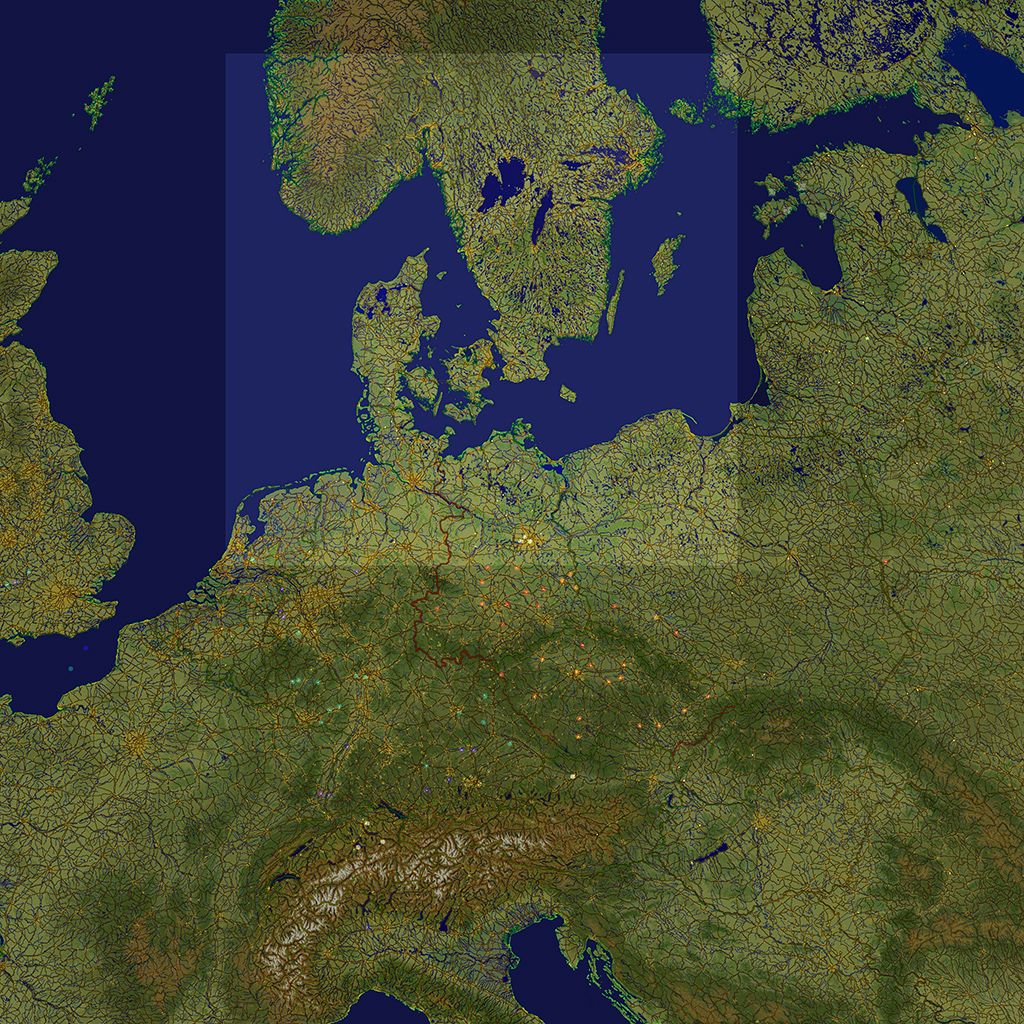
Lukas,
I finally had the time to check the Ostsee 2.03 map using Google Earth. Here are the best parameters I could find to minimize the map distortion:
 <theater id="Ostsee"><terrain>Data/Terrain/Falcon 4.0/Ostsee Falcon 4.0 Terrain.dat</terrain>
	<database>Data/Database/Falcon 4.0/Ostsee Falcon 4.0 Database.dat</database>

	<lod>2</lod>
	<west>4</west>
	<east>20.6</east>
	<south>52</south>
	<north>61.2</north>
	<visible>1</visible>
	<timezone>+2</timezone></theater>
I think there is an error in theater.map declarations for the Ostsee theater 2.03: L0 to L5 (and probably the MEA too) are twice as big as they should be based on the amount of data available in THEATER.O2
Anyway, I have temporarily hacked the data to be able to load it and add preliminary support of the Ostsee theater in Tacview 1.5.3 beta 4 which should be released in a few days.
-
…yes, becouse I used my 128seg. NATO map file and tweaked only the central point…I forgot to edit more values
BTW was that “sinusoidal” info usefull?
-
I did not have the time yet to consider different projections.
However, I will definitively check the sinusoidal projection you are describing when I will do another pass on Falcon 4.0 terrain support.
-
Tacview 1.5.3 is out!
Download: http://tacview.net/download
This new intermediate release brings a log of fixes and improvements for all your favorite flight simulators from Falcon 4.0 to X-Plane 11. At last, DCS World is the last flight simulator to get a brand-new exporter based on the new telemetry system which was introduced in Tacview 1.5. The new C++ exporter offers improved performance over the old LUA one (self CPU use is down from about 11% to 1.5% on average). More data is exported, recordings are much smaller, and you can even inject bookmarks while flying by pressing RALT+B!
This version is the last step before the long awaited real-time flight analysis! Tacview 1.6 Professional will – soon – enable you to review a flight currently in progress. A remote control will also enable you to control the local aircraft of the session you are connected to. This can be a handy feature to initiate your friends into your favorite flight simulator and to oversee in real-time a battlefield like Red-Flag operations.
These new features will be first available for DCS World, quickly followed by FSX and X-Plane, and perhaps even Falcon 4.0, if possible. Feel free to contact me if you think that you can provide me with any helpful information concerning real-time data export for Falcon 4.0.
I will soon produce several video tutorials to help you get the most out of Tacview.
Blue skies and happy new year!
VyrtuozFEATURES & CHANGES
- Added support for X-Plane 11
- X-Plane data recorder now makes a distinction between fixed wings and helicopters
- Brand new flight data recorder for DCS World
- DCS World mission title, type, description, and briefing are now exported
- DCS World mission bullseyes are now exported
- DCS World exporter sampling frequency have been optimized to reduce produced files size
- DCS World exporter CPU load has been reduced from 11% to 1.5% CPU in loaded battlefield
- Added RALT+B to save a bookmark in the flight recording while flying in DCS World
- Local player vehicle magnetic heading is now exported for DCS World
- Added mission name in DCS World flight recordings
- Local player vehicle change is gracefully handled by the new DCS world exporter
- Added an option to delay flight playback to prevent cheating when online with DCS World
- Added an option to generate one file per connected client to your DCS World server
- Added support for C-101 Aviojet (DCS World) advanced telemetry
- Improved advanced telemetry for many DCS World aircraft
- Added support for DCS: L-39 Albatros
- Added support for DCS: M-2000C
- Added support for DCS: SA342 Gazelle
- Added support for DCS: Spitfire LF Mk. IX
- Integrated the latest Nevada map from DCS World (new airports will follow)
- Added a warning when loading a file with null spherical or flat coordinates
- Added Falcon 4 Pillars of Hercules 0.7.8.2 theater
- Integrated Balkans terrain and database for BMS 4.33 U3
- Updated Ikaros theater for BMS 4.33 U3 to version 4.0.0
- Added preliminary support for Ostsee Falcon 4.0 theater
- User settings WILL be preserved when updating to a new version
- Added support for laser beams
- Added command line option /DataCollection:off to disable anonymous data collection
FIXES
- Fixed crash when displaying bullseyes in charts
- Fixed a rare crash when loading corrupted acmi 1.x files
- Fixed random online debriefing host crash when an obsolete client attempt to join the session
- DCS World mission date is now always correct
- Reference time is now properly set to 2004-05-14 for all Falcon 4.0 flights
- Identical flight events are now properly loaded and stored separately
- Matra missiles are now stored with distinct names in DCS World acmi files
- X-Plane data recorder now better handles time travel using keyboard shortcuts
-
Hey Virtuoz,
During a recent flight debriefing, we noticed an inconsistency between what we saw in-game and in Tacview (v1.5.4), and before we take it to the BMS devs (though I’m fairly certain they’ll pick it up here anyway), I wanted to get your input on the matter.
Basically, what we encountered is the following situation:
In-game, coming out of a right turn, I have a contact on my right gimbals (at 57°).Later, reviewing the mission in Tacview, all of us thought it should’ve been impossible for me to see that particular contact. I took a screenshot to check how far off-centre the contact was, and ended up with this.
Since it was a right turn, we believe it’s (almost) impossible the FCR provided a memory projection of a contact picked up earlier. Obviously, we also checked the BMS data, and confirmed that FCR gimbals are set at 120° (60° to each side), just like we expected from an F-16 sim.
So my question now is, how much of an error margin is there in Tacview when it comes to (player) position information? Is this an inconsistency because of Tacview, or a possible bug in BMS?
Kind regards,
Eagle-Eye -
Thank you very much for the feedback Eagle-Eye.
It looks like there is a lot of geographical distortion in the area you are flying in. It is possible that I made a mistake in angles calculations (forgot to use native coordinates instead of spherical ones for example).
Which theater are you flying in? Can you share the corresponding original VHS file? If not, can you record another VHS file in the same area?
-
This was flown in Balkans, about 15-20NM west-southwest of Aviano, so it is in fact quite close to the theatre boundaries. I’m unable to share the VHS, but we can do some more testing if you like. (unknown when, however)
-
Balkan theatre is not sphericaly projected IIRC (very distorted)
-
In that case, can you share me the acmi file we can see on your screenshot?