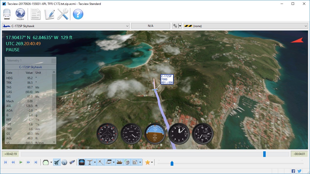
Tacview – Understand what happened during your last flight! (alternative ACMI viewer)
-
Tacview 1.6.4 is available!
This intermediate release is manly focused on fixes and brings several improvements which have been requested for a long time (like the look-at dogfight camera).
Tacview 1.7 is already in development and will offer improved modules and tools related to customization. Like a new and smart database for the objects of the battlefield, as well as new module to manage navaids, airspaces, runways, ILS and so on.
Enjoy!
VyrtuozDownload: http://tacview.net/download
FEATURES & CHANGES
• Added support for NMEA 0183 GPS files
• Added a Look-at camera mode to the dogfight camera
• Added IL-2 Sturmovik: Battle of Kuban terrain
• When not available, magnetic heading is now calculated using IGRF-12 models
• The line-of-sight between selected objects is now displayed in red when obstructed by terrain
• Attitude indicator, HIS and HUD heading indicator are now emulated when no rotation information is available
• Real-time telemetry and remote-control TCP ports can now be customized in DCS World exporter options
• Gear handle status is now recorded by FSX2ACMI
• It is now possible to mouse-hover buildings to display any available debug info
• Tacview will now display if the file is authentic, not altered since its recording
• Added more predefined types in the object properties editor
• You can now double click to restore the default aircraft trail size
• Boosted by a factor of two terrain texture resolution for the highest level of detail
• Updated BMS Ostsee theater to version 3.28.88
• Added BMS Nordic 2.0 theaterFIXES
• Mouse input (rotation, zoom…) is now giving the same result regardless on screen DPI
• Flaps status is now properly recorded for all FSX aircraft (e.g. A2A ones)
• Export Flight Log was not always working with Falcon 4.0 flight recordings
• The last lines of nmea and text acmi files was not always read (regression)
• Custom rectangular terrain textures were not always properly displayed
• Objects violating altitudes restrictions were not blinking anymore
• Debug console and log now properly output a full date including seconds
• Fixed multiple minor bugs in dockable windows
• The exporter will now properly work when the user’s name contains dots
• ExportFlightLog command was not exporting csv files when multiple file extension was used -
Hello Vyrtuoz,
How do I use Real Time Telemetry in BMS?
Or is it only for DCS and FS?
Regardless, thanks very much for this very awesome tool!!
Pika. -
Hello Pika,
Real-time telemetry is currently supported by DCS, FSX and X-Plane.
It is not yet supported by BMS. If this can be done, I have planned to make a first prototype in the coming months. The first step will be to read BMS flt files. If theses files are readable while BMS is writing them, then we should be able to have real-time telemetry, maybe with a slight delay.
Stay tuned!
-
Hello Pika,
Real-time telemetry is currently supported by DCS, FSX and X-Plane.
It is not yet supported by BMS. If this can be done, I have planned to make a first prototype in the coming months. The first step will be to read BMS flt files. If theses files are readable while BMS is writing them, then we should be able to have real-time telemetry, maybe with a slight delay.
Stay tuned!
It’s doable. A wingmate and I have done it.
-
Vyrtuoz,
Use shared memory provided by BMS. It comes with all data you need. It takes very few clicks to implement it in c++. Have done that even in Labview and MatLab for fun.
-
Vyrtuoz,
Use shared memory provided by BMS. It comes with all data you need. It takes very few clicks to implement it in c++. Have done that even in Labview and MatLab for fun.
Shared memory, to my knowledge, does not contain enough data to display anything but ownship information. The flt has everything that winds up in a .vhs or .acmi file.
But yes, if all you want is ownship position and gauges (and lots of awesome stuff), shared memory is the way to go.
-
The question was on telemetry and I read as of my own acft. But you are of course right if the data of other acft is also desired.
-
Good news!
I took the time to do more tests and it looks like it is possible to read BMS flt files in real-time. Now, I am still concerned about the objects coalitions/colors which, apparently, is not stored before the flt file is closed. But this should be ok if we limit the size of flt to something small.
Now, there is a big chance we can get real-time telemetry with Falcon 4. I still have other tasks to complete before working on it, but I am as eager as you to see a first prototype running!
-
Would someone to let me know how to display ground targets like bridges? I am learning JDAM with Mission 15. I would like to check if my JDAMs hit the right target by Tacview.
-
Ground objects are not yet available.
I think this can be done, but this will be for a later update.
-
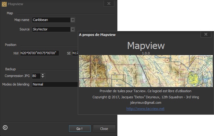
Jacques ‘Detox’ Deyrieux has just released Mapview 1.0.0, a great program to create VFR maps for Tacview in just a few minutes!
Simply add the region of your choice in the maps.ini file (do not forget to add the region in the GLOBAL section of the ini file). Launch Mapview. Adjust some of the parameters, and click [Go!].
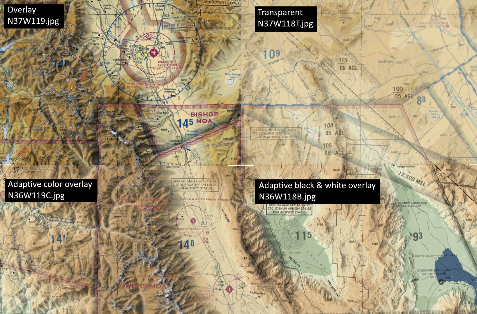
Three new jpg textures modes have been added to Tacview 1.7.0 beta 2: adaptive black & white, adaptive color, and transparent. They will be available soon, till Tacview 1.7.0 beta 2 is released, make sure the blending mode is set to [Normal].
The next version of this wonderful program will be able to generate maps with OpenStreetMap as well as orthophoto from Bing maps!
Thumbs up to Detox! :thumbup:
Mapview is available here: http://www.tacview.net/download/addons/#mapview
Blending modes available in Tacview 1.7.0 beta 2:
-
Oh my…!!

-
You rock, guys !!!
-
You…. METALLLLLL !!!
-
A great add-on for Tacview, however the Falcon4 objects such as airbases, do not line up with the map objects.
Is this an alignment issue with the map relative to Tacview terrain?
For what it’s worth, I plugged the Tacview theater co-ordinates into Mapview to produce the chart.
-
Hi Steve_U
LLBG have GPS position in SkyVector N32°0.57’ E34°53.13’ and in Tacview it’s the same coordinate
There is one eventuallity : Flacon BMS provide a bad position. I don’t have BMS installed to check GPS position provided for LLBG can you verify.
For information : with DCS and XPlane, there is not alignement issue.
Regards
Detox
Mapview v1.2.0 link to the latest version : https://drive.google.com/drive/folders/1SL3EXcbXrZ-YOlGJbDUsQ23fs2YgPZKz?usp=sharing
take few minutes to read maps.ini and readme.txt, there are few changes -
-
-
-
There is one eventuallity : Flacon BMS provide a bad position. I don’t have BMS installed to check GPS position provided for LLBG can you verify.
For information : with DCS and XPlane, there is not alignement issue.
AFAIK, X-Plane, MSFS and Prepar3D (possibly DCS as well, but that’s to be confirmed?) use a sphere model to simulate the earth, while BMS uses a flat projection and works from a corner (top left, IIRC?) to produce coordinates. Because of this, like any 2D map of a 3D object, there is a distortion in BMS the further you go from the zero-point.
Not sure if there’s a way to overcome that, since Tacview also uses a sphere model. The first thing that comes to mind is to get BMS theatre zero-point coordinates and rate of distortion, and warp the real map to match BMS, but not sure if that map would then still line up with Tacview’s 3D earth?
")