Aegean Theatre - IAP charts
-
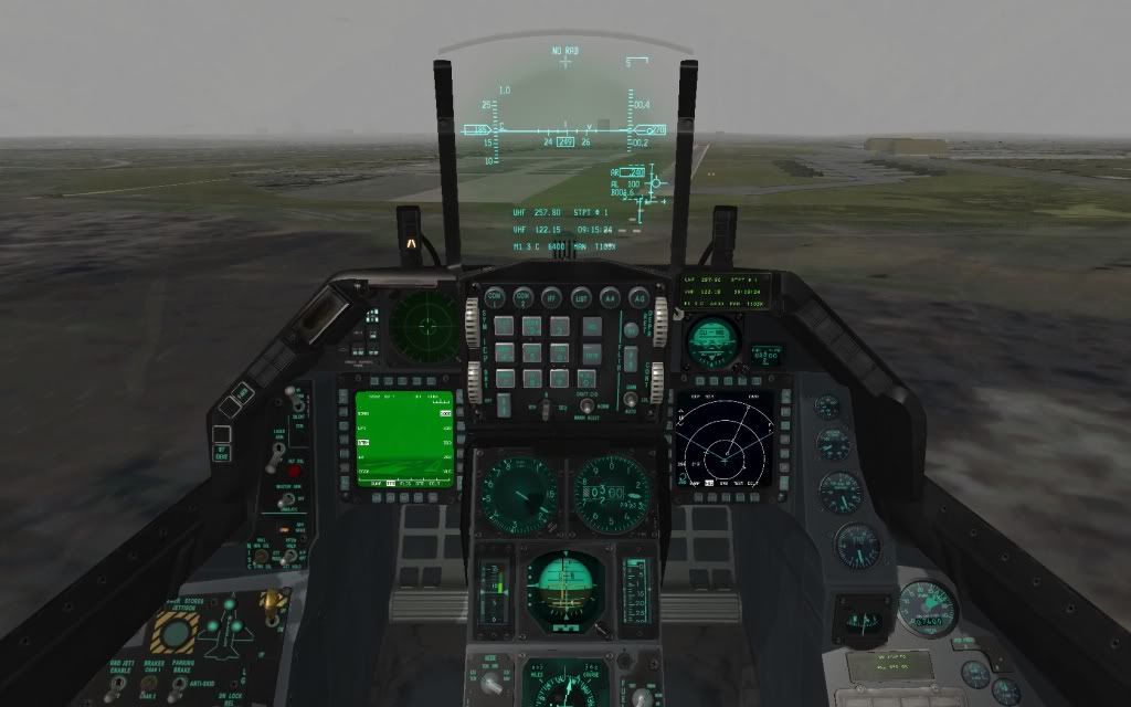
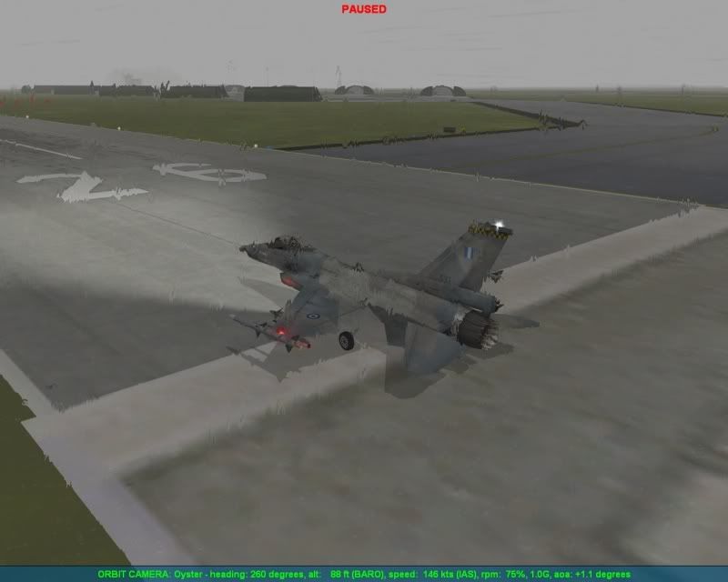
I had forgotten it. Landing with bad weather and crossed wind. How you can see I go high, I was not relying too much of the instruments :rofl:
Hi mate .
As i can see from the above photo , a little high and following an ILS approach .
If you want , next time try the TACAN approach , as it is in the chart") .
.
It’s much more challenging .
With my regards .
Nikos . -
Actually, i think that IFR flying is much more safer …. it brings you on the right altitude at the right speed and you land at the right approach angle … it is safe :).
Keep up the very good work.
Spooky.
-
Actually, i think that IFR flying is much more safer …. it brings you on the right altitude at the right speed and you land at the right approach angle … it is safe :).
Keep up the very good work.
Spooky.Hi my friend .
You are right about that IFR flying is much more safer . And TACAN approach is a non-precision instrument approach and execute it with IFR .
See you mate .
Nikos . -
And an approach by me with these weather conditions :
Weather: Inclement
Wind: Deterministic 350 Deg. (90 deg. crosswind to RWY 26)
Max. Speed 5 Kt
Wind Burst 8 Kt Direction 20 Deg.
Fog: Start 0 Ft End 5,000 Ft .
Well even with the above weather values , the IAP chart guide me right to RWY 26 threshold . The key is to be precise on localizer at final turn , means at ANL R-090/2.5 DME .
With my regards .
Nikos . -
Your job is perfect my friend!!
-
Good job, buddy!
Tom
-
Your job is perfect my friend!!
Thank you “desert eagle” for your nice comments .
If you try the approach , post your remarks .Good job, buddy!
Tom
Hey mate , where are you ?
I don’t think to try the ILS until now ….
Taste the TACAN approach as the IAP chart shows . It’s a real challenge . You will love it .
With my regards .
Nikos . -
Could you Verify.
-
Could you Verify.
Hi my friend .
These are IAP charts for greek airports , but are civil ones . I mean that they are VOR/DME or NDB approaches and not TACAN or VORTAC that use the military aircrafts like the F-16 and others .
My IAP chart of Nea Anchialos is based on real TACAN approach .
With my regards .
Nikos . -
hi Nikos
If yo access to the page i can see that they are military airport with her Tacan. The others are civil.
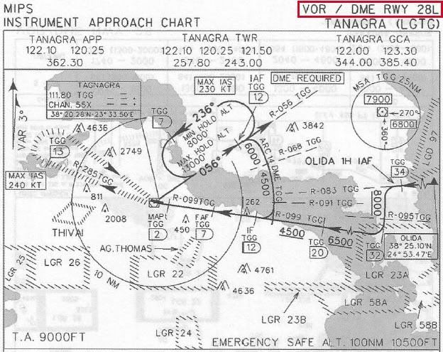
Example. LGAD, LGBL, LGEL, LGLR, LGSR, LGTG, LGTL, LGTT and this charts has Tacan.
regardsExample Tanagra :http://www.fileserve.com/file/mCFShWT/Tangra Charts (LGTG).PDF
-
hi Nikos
If yo access to the page i can see that they are military airport with her Tacan. The others are civil.
Example. LGAD, LGBL, LGEL, LGLR, LGSR, LGTG, LGTL, LGTT and this charts has Tacan.
regardsExample Tanagra :http://www.fileserve.com/file/mCFShWT/Tangra Charts (LGTG).PDF
Hi my friend .
Well there is a misunderstanding by you . Let me help you to clear it .
At my previous post i said : “These are IAP charts for greek airports , but are civil ones . I mean that they are VOR/DME or NDB approaches and not TACAN or VORTAC that use the military aircrafts like the F-16 and others .
My IAP chart of Nea Anchialos is based on real TACAN approach .”
As you can see i didn’t said that the airports were civil , i said that the IAP (Instrument Approach Procedure) charts are civil and actually they are .
The airports that you mention are military and of course has a TACAN station , but at the specific site that you give they have approach charts only for civil use (VOR/DME or NDB approaches) . And at example of Tanagra airbase that you give , you will see at pages 5 and 6 the VOR/DME approach to RWY 28 . Below is the page 6 of Tanagra pdf :
Now take a look at a TACAN approach chart :

and at a VORTAC approach chart :
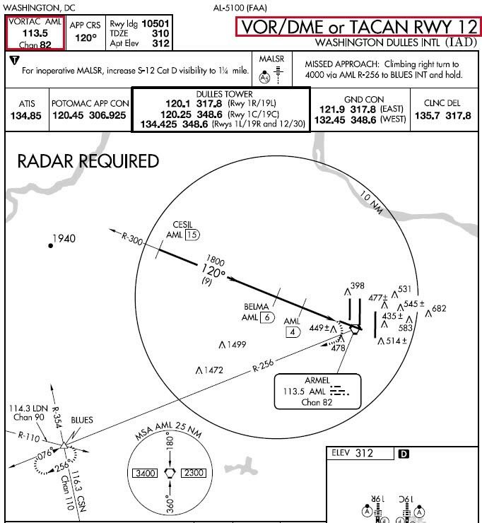
The military aircrafts can only have a distance (DME) indication of a VOR/DME station and not a bearing indication , if they set the appropriate channel , e.g. for Tanagra VOR/DME approach is the channel 055X (from TGG VOR/DME station) .
So these approaches ARE NOT FOR USE WITH MILITARY AIRCRAFTS !
I think now to be clear for you that all of these charts of the specific site are for civil use . So we can not use them to create charts for Aegean theater because we need TACAN or VORTAC approaches charts .
With my regards .
Nikos . -
WoWwwwww … super … good job Nikos
thanks a lot again … -
u know what we want to see with those beautiful TACAN charts of Tanagra… the electricity cables with the metallic balls for avoidance… Oh dear dream on Arty…
On the other hand this could be done just for airports…
like a huge long bridge…
Right?
Am I right?
and at the ends have the cables go down to earth like going underground… Right? Right?
PLEAAAAASSSSSEEEEEE???
Yea I know…
1. O.T. Sorry couldn’t hold it…
2. Yea why don’t I do it by myself…HOT LIST

System Specs:
i7-2600K @ 4.8 Ghz WaterCooled / 32GB Ram. 128GB SSD/1TB SSD / GTX1080Ti 11GB DDR5X / HOTAS COUGAR. TrackIR 4 / 3x24" Mon. (res:5760x1200) / Cougar MFD's / Wheel Pedals / Win 10 64 bit.

-
u know what we want to see with those beautiful TACAN charts of Tanagra… the electricity cables with the metallic balls for avoidance… Oh dear dream on Arty…
On the other hand this could be done just for airports…
like a huge long bridge…
Right?
Am I right?
and at the ends have the cables go down to earth like going underground… Right? Right?
PLEAAAAASSSSSEEEEEE???
Yea I know…
1. O.T. Sorry couldn’t hold it…
2. Yea why don’t I do it by myself…Hi my friend .
Do you want that pylons inside the theater or to show them in IAP chart ?
Personally i have not see them in any IAP chart . If you have , please post a photo of this chart .
Nikos . -
Hi my friend .
Do you want that pylons inside the theater or to show them in IAP chart ?
Personally i have not see them in any IAP chart . If you have , please post a photo of this chart .
Nikos .lol I believe the chart covers them… else the pilot will see them… they are just vertical to the runway after the highway towards Athens. Trying to find some pics…
HOT LIST
System Specs:
i7-2600K @ 4.8 Ghz WaterCooled / 32GB Ram. 128GB SSD/1TB SSD / GTX1080Ti 11GB DDR5X / HOTAS COUGAR. TrackIR 4 / 3x24" Mon. (res:5760x1200) / Cougar MFD's / Wheel Pedals / Win 10 64 bit.
-
lol I believe the chart covers them… else the pilot will see them… they are just vertical to the runway after the highway towards Athens. Trying to find some pics…
Copy that .
")
Nikos . -
Hi guys.
Well after the IAP (Instrument Approach Procedure) chart for Nea Anchialos airbase in Greece, now it’s time for the IAP chart of Balikesir airbase in Turkey, home of 2 squadrons of F-16 block 50 in real life.
Below you can see a preview of the chart, that is a jpg photo:
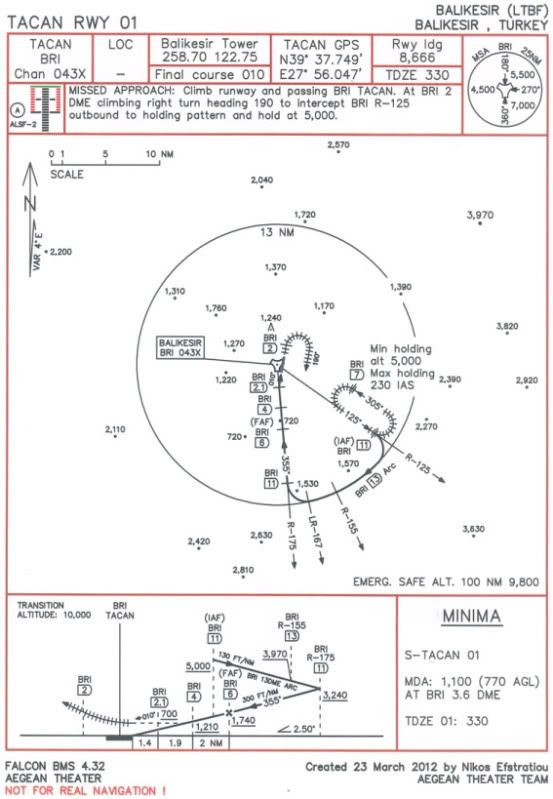
Download both charts and the updated NavAids for Balikesir and Nea Anchialos airbases (just to work without conflicts) from here (instructions included in the zip file), file “Aegean_IAP_charts.zip” 689 KB:
RE-DOWNLOAD THE ZIP FILE, ALSO INCLUDED THE 2 PROCEDURES (HOW TO EXECUTE THEM)!
https://hotfile.com/dl/150245284/7633289/Aegean_IAP_charts.zip.htmlPrint the jpg photos to A4 paper size (21X29.7 cm or 8.3X11.7 inches).
Then copy the “stations+ils.dat” file to correct location, just like the “Installation instructions.txt” said.
All the data from Balikesir IAP chart are conformal with the updated NavAids, but from the IAP chart of Nea Anchialos the tower UHF and VHF frequencies are different, so even if the chart gives UHF / VHF frequencies: 257.80 / 122.10 please use them: UHF / VHF frequencies: 257.85 / 122.15 for Nea Anchialos!
TACAN range for Balikesir is 25 NM and for Nea Anchialos is 100 NM.Now let me give you SOME USEFUL INFOS ABOUT THE PROCEDURE:
1) In order to have a perfect alignment with runway centerline and because of the fact that the DME of the last waypoint has a decimal digit, you must insert GPS coordinates of TACAN station over a steerpoint and make this steerpoint current, so you can turn to final approach course aligned with runway centreline at exactly DME of last waypoint!
You also must set the Instr mode to NAV and set the appropriate course at HSI, e.g. for final approach segment for Balikesir is 355 and for final approach segment for Nea Anchialos is 270.
2) It is critical that at FAF waypoint (or steerpoint) be at precise altitude with landing gears down and air brakes extended. Then at FAF DME start your descent with 2.5 degrees. There is an intermediate waypoint between FAF and last waypoint (that you turn to final approach course) just for altitude check and minor corrections.
3) Missed approach turn and holding turns must be executed with turn radius of 1.1 DME (N.M.), meaning IAS 200 knots and bank angle of 30 degrees.
4) Turns to join the arc (12 and 13 DME) and to leave it, must be executed with IAS 250 knots and bank angle of 30 degrees.
5) Rates of descent:
i) Balikesir: 130 FT/NM = 1.2 degrees, 300 FT/NM = 2.8 degrees.
ii) Nea Anchialos: 235 FT/NM = 2.2 degrees, 265 FT/NM = 2.5 degrees.
6) In Falcon BMS we have wind (it works), so even if you may be precisely on CDI and turn exactly at last waypoint (or steerpoint), you may find yourself a little offset of runway. If this happens, do that: i) For Nea Anchialos a) If you are offset and LEFT of runway, then execute a Missed approach and start a new approach. But this time turn at last DME - 0.1 = 2.4 DME (and not at 2.5 DME). b) If you are offset and RIGHT of runway, then execute a Missed approach and start a new approach. But this time turn at last DME + 0.1 = 2.6 DME (and not at 2.5 DME).
ii) For Balikesir we do exactly the opposite a) If you are offset and LEFT of runway, then at new approach turn at last DME + 0.1 = 2.2 DME (and not at 2.1 DME). b) If you are offset and RIGHT of runway, then at new approach turn at last DME - 0.1 = 2.0 DME (and not at 2.1 DME).
- The charts are under scale, so they are extremely precise. Everything has precise bearing, distance and altitude.So funs of Aegean theater get the charts and try them.
If you want to ask something about the procedure, something that you don’t understand, please feel free to do that. My pleasure to help you.
I hope to enjoy also this new IAP chart for Balikesir airbase.
With my regards and from all other “Aegean Theater Team” members.
Nikos Eystratiou. -
good job,thanks for sharing.
-
+1 here, it will be one more nice and accurate job of yours as your usual, Nikos.
Keep on straight this way, uaglio’ (said in barese way):D
Gianni.
-
Once again, your work is great my friend…;)