Aegean Theatre - IAP charts
-
lol I believe the chart covers them… else the pilot will see them… they are just vertical to the runway after the highway towards Athens. Trying to find some pics…
Copy that .
")
Nikos . -
Hi guys.
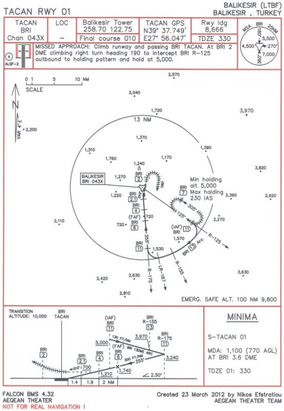
Well after the IAP (Instrument Approach Procedure) chart for Nea Anchialos airbase in Greece, now it’s time for the IAP chart of Balikesir airbase in Turkey, home of 2 squadrons of F-16 block 50 in real life.
Below you can see a preview of the chart, that is a jpg photo:
Download both charts and the updated NavAids for Balikesir and Nea Anchialos airbases (just to work without conflicts) from here (instructions included in the zip file), file “Aegean_IAP_charts.zip” 689 KB:
RE-DOWNLOAD THE ZIP FILE, ALSO INCLUDED THE 2 PROCEDURES (HOW TO EXECUTE THEM)!
https://hotfile.com/dl/150245284/7633289/Aegean_IAP_charts.zip.htmlPrint the jpg photos to A4 paper size (21X29.7 cm or 8.3X11.7 inches).
Then copy the “stations+ils.dat” file to correct location, just like the “Installation instructions.txt” said.
All the data from Balikesir IAP chart are conformal with the updated NavAids, but from the IAP chart of Nea Anchialos the tower UHF and VHF frequencies are different, so even if the chart gives UHF / VHF frequencies: 257.80 / 122.10 please use them: UHF / VHF frequencies: 257.85 / 122.15 for Nea Anchialos!
TACAN range for Balikesir is 25 NM and for Nea Anchialos is 100 NM.Now let me give you SOME USEFUL INFOS ABOUT THE PROCEDURE:
1) In order to have a perfect alignment with runway centerline and because of the fact that the DME of the last waypoint has a decimal digit, you must insert GPS coordinates of TACAN station over a steerpoint and make this steerpoint current, so you can turn to final approach course aligned with runway centreline at exactly DME of last waypoint!
You also must set the Instr mode to NAV and set the appropriate course at HSI, e.g. for final approach segment for Balikesir is 355 and for final approach segment for Nea Anchialos is 270.
2) It is critical that at FAF waypoint (or steerpoint) be at precise altitude with landing gears down and air brakes extended. Then at FAF DME start your descent with 2.5 degrees. There is an intermediate waypoint between FAF and last waypoint (that you turn to final approach course) just for altitude check and minor corrections.
3) Missed approach turn and holding turns must be executed with turn radius of 1.1 DME (N.M.), meaning IAS 200 knots and bank angle of 30 degrees.
4) Turns to join the arc (12 and 13 DME) and to leave it, must be executed with IAS 250 knots and bank angle of 30 degrees.
5) Rates of descent:
i) Balikesir: 130 FT/NM = 1.2 degrees, 300 FT/NM = 2.8 degrees.
ii) Nea Anchialos: 235 FT/NM = 2.2 degrees, 265 FT/NM = 2.5 degrees.
6) In Falcon BMS we have wind (it works), so even if you may be precisely on CDI and turn exactly at last waypoint (or steerpoint), you may find yourself a little offset of runway. If this happens, do that: i) For Nea Anchialos a) If you are offset and LEFT of runway, then execute a Missed approach and start a new approach. But this time turn at last DME - 0.1 = 2.4 DME (and not at 2.5 DME). b) If you are offset and RIGHT of runway, then execute a Missed approach and start a new approach. But this time turn at last DME + 0.1 = 2.6 DME (and not at 2.5 DME).
ii) For Balikesir we do exactly the opposite a) If you are offset and LEFT of runway, then at new approach turn at last DME + 0.1 = 2.2 DME (and not at 2.1 DME). b) If you are offset and RIGHT of runway, then at new approach turn at last DME - 0.1 = 2.0 DME (and not at 2.1 DME).
- The charts are under scale, so they are extremely precise. Everything has precise bearing, distance and altitude.So funs of Aegean theater get the charts and try them.
If you want to ask something about the procedure, something that you don’t understand, please feel free to do that. My pleasure to help you.
I hope to enjoy also this new IAP chart for Balikesir airbase.
With my regards and from all other “Aegean Theater Team” members.
Nikos Eystratiou. -
good job,thanks for sharing.
-
+1 here, it will be one more nice and accurate job of yours as your usual, Nikos.
Keep on straight this way, uaglio’ (said in barese way):D
Gianni.
-
Once again, your work is great my friend…;)
-
Hello Nikos my friend,
First: thank you for the gift to make my TE as it should be
Second: Very interesting to start from Balikesir airbase, that is used in real RL with F-16 of the Turkish air force.
Thank you to all members of the Aigais theater - another step to perfection was made by you guys.
Maybe my question is premature - you’ve done something in terms of the "point of interest " ?
Turkey and Greece as well is the historical cradle of Europe, in this matter I like to ask you - how is this in the theater.
For example:
Turkey: Pamukkale - Istanbul (The Blue Mosque), the Bosborus bridges,Troya e.c
Greece: Acropolis, the ancient harbor of Rhodes. Just to name a view - some of those places would be nice to see in the theater.
I guess I just wait and see what you guys come up with.
σας ευχαριστώ - teşekkür ederim
regards Falcontower
-
I have to admit I am too dumb for this. I tried it the way (easy of course) I recall from tutos with larger airbases and just could not find the ILS frequency, so I guess I am making a public noob out of me hehe and simply need to deal with frequencies.
Anyway, took some nice “bust the tower” screens I will post in the big screenshot thread by the former member TAGMAN…
Cheerio
-
At “141st_Kaplan”, “Jackal” and “desert eagle”:
Thank you guys for your kindly words. I’m glad that you like the second IAP chart of Aegean theater that published.
At “Falcontower”:
Hi my friend. Well you can enjoy the IAP chart of Balikesir with your falcon pilots and have a great T.E. with real procedure to land at the Balikesir airport!
At all Aegean funs:
If you have any questions about the procedure, please feel free to ask me. My pleasure to help you ;).
With my best regards.
Nikos. -
I have to admit I am too dumb for this. I tried it the way (easy of course) I recall from tutos with larger airbases and just could not find the ILS frequency, so I guess I am making a public noob out of me hehe and simply need to deal with frequencies.
Anyway, took some nice “bust the tower” screens I will post in the big screenshot thread by the former member TAGMAN…
Cheerio
Hi my friend Thorsten.
Well the specific IAP chart for Balikesir airbase is a TACAN approach and NOT an ILS approach. Balikesir airport have not ILS system in real life, also in Aegean theater. So you must use the TACAN station of Balikesir airport in order to have an aid to land to it. And in order to have a precise last turn, you must insert the GPS coordinates of TACAN station (chart give them) over a steerpoint and make it current and set your Instr Mode to NAV.
So this is the way that you must do it:
First you must start the procedure from the IAF (Initial Approach Fix) waypoint (or steerpoint), means from BRI R-125/11 DME at 5,000 ft. (BRI=the ID of the TACAN of Balikesir, R=radial-the course at HSI, DME=NM=Nautical Miles).
Even if you approach the airport from East, you can pass the IAF waypoint and make a turn to heading to it. Also you must manage to reach it with speed of 250 knots.
Then when you are exactly at 11 DME, you must start your right turn to join the 13 DME arc with 30 degrees of bank (and speed of 250 knots) and simultaneously start your descent with 130 FT/NM = 1.2 degrees. When you are at R-155 you must check your altitude and you must be at about 3,970 ft. If you are a little upper or lower you must correct your altitude accordingly. After pass the R-155 you set at the HSI for course 167, which is the LR (Lead Radial=the radial that we starting the turn to the final approach course inbound to airport). So when you are just at R-167, start your right turn with speed of 250 knots and 30 degrees of bank. This guides you over R-175 and at 11 DME inbound to airport. At this point and if you have had manage a good descent you must be at about 3,240 ft. Now set at HSI course of 175 (or 355) and continue the descent but from this waypoint with rate of 300 FT/NM = 2.8 degrees while keeping the CDI at the HSI centered. Now the most importan section of the approach: You must manage to be at FAF (Final Approach Fix) waypoint (or steerpoint) which is at BRI R-175/6 DME at exactly 1,740 ft. This is very critical, because at FAF waypoint you start the final descent with rate of 265 FT/NM = 2.5 degrees. That means you guide your fpm (flight path marker) just over the 2.5 degrees pitch ladder dive and keep it (the fpm) there until you reach the threshold area. Simultaneously you keep the top of AOA (Angle Of Attack) bracket just to the same level with your fpm (this gives you 11 deg. AOA). At BRI R-175/4 DME you can check your altitude and must be at about 1,210 ft. If you are not near, you must do minor corrections. Then last action is to make the final turn to runway, this is done at BRI R-175/2.1 DME and you turn to 010 degrees. At this waypoint you must be at about 700 ft. Then you keep the heading of 010 degrees and you must see the runway threshold area (and if it is night the ALS-Approach Lighting System, for Balikesir is type ALSF-2 see the chart at top and left). If needed you must do minor corrections to your heading and then you have a touch down.
If something goes wrong, you can execute a missed approach (as described in chart) and start a new approach.So my friend i think that now it’s much more clear what you must do ;).
Try it after that and tell me if this helps. If you have any more questions, just ask me, i’m here.
With my regards.
Nikos. -
Thank you very much, Nikos!
TBH: I rather doubt I will manage this without trying ca 30 times, but I am impressed by your indepth knowledge!
Bravo…I will download your instruction and save it together with your navigation charts.I will also try it and in any case thank you my friend…!
I think it is good that the Luftwaffe lost me as pilot (I decided to not go there almost being enlisted and training)…because I definately would have made my landings Sledge Hammer style…

Cheers
Thorsten
-
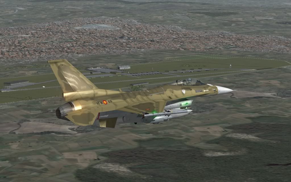
Well, there we go…
Trying the landing in Balikesir AFB. Actually very few times, due time or laziness, we land following the pattern indicated in the charts and I have to say that it´s wonderful: I enjoyed it! Next time I try it without turbulences because I have “felt” a little stress. I can´t check and take caps at same time (Hence the small deviation, altitude and the fall of speed)
The pics…
Recce of AFB
Intercepting course of exit
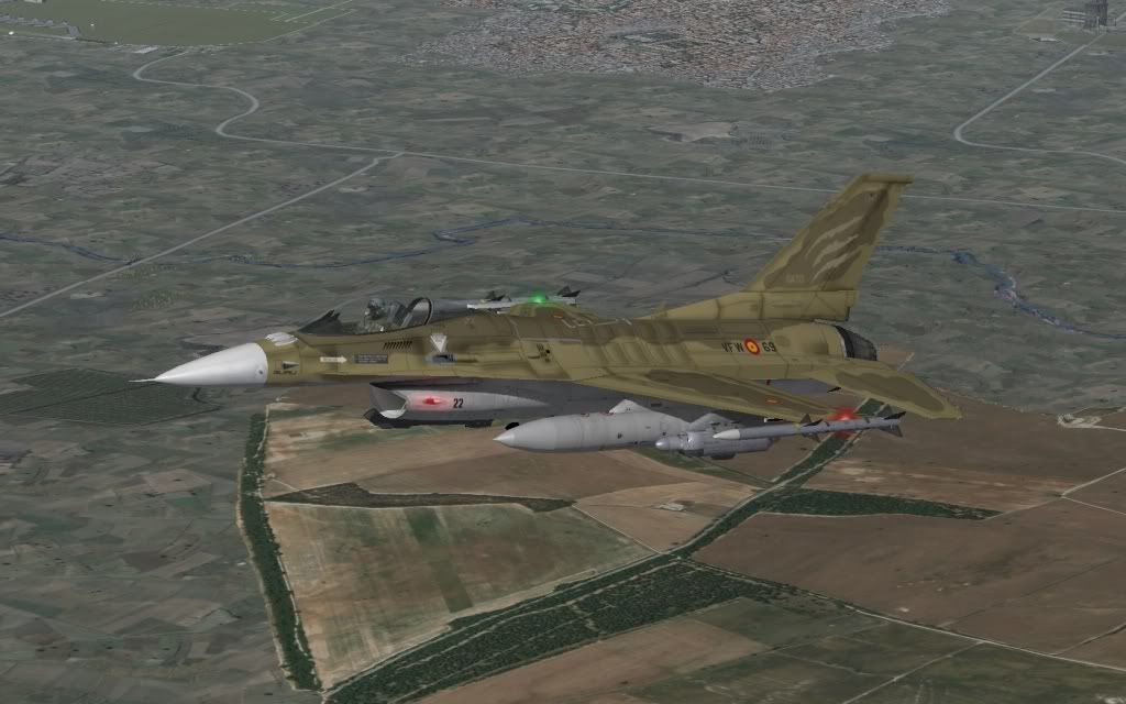
R-175(355) and close to the final turn
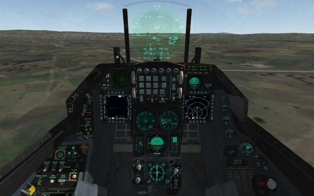
On “final” final (:D), 010
Parking
Nikos
"I did find myself […] looking into the face of those SA-8s and the two Rolands. My impression of why I survived is that here I am, with the radar cross-section the size of Mount Rushmore, and here are these Iraqi SAM missile operators going, 'Cease fire, Cease fire, don´t shoot! Here´s two dumb Mike Foxes at 20,000 feet and 200 knots-you know, must be Iraqi, hold fire, hold fire!' I think that´s the only thing that saved us"
-
Well, there we go…
Trying the landing in Balikesir AFB. Actually very few times, due time or laziness, we land following the pattern indicated in the charts and I have to say that it´s wonderful: I enjoyed it! Next time I try it without turbulences because I have “felt” a little stress. I can´t check and take caps at same time (Hence the small deviation, altitude and the fall of speed)
The pics…
R-175(355) and close to the final turn
On “final” final (:D), 010
Nikos
Hi my friend Thomas.
Very good approach and “by the book”. At the 1st photo “R-175(355) and close to the final turn” you are almost perfect (only a little lower, but inside the limits)!
My congratulations for the great execution of the procedure!
Obviously you got the point which is: just before the final turn at BRI R-175/2.1 DME you must be exactly on centered CDI, as close as possible! Then if you turn to 010 heading (from 355 heading) just at 2.1 DME you will find yourself very well aligned with runway 01 centerline.
I’m very pleased that you find the IAP chart for Balikesir helpful ;).
So until next one, my regards mate.
Nikos. -
Hi guys.
After some "pm"s that i got, i must clarify you a misunderstanding.
At Nea Anchialos IAP chart, a lot of Aegean falcon pilots think that this chart uses the ILS system as navaid for the approach. This is wrong. Nea Anchialos airbase may have TACAN station and ILS system in runway 26, but the specific chart that I made is a TACAN approach to RWY 26. You may see at chart the ILS LOC (localizer) frequency which is 110.90 (see photo below):
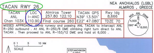
but this is just to inform the pilot that the RWY 26 has ILS. The approach based to TACAN as navaid. The type of approach is seeing at top left corner (green circle): TACAN RWY 26.
Now let’s see the ILS approach chart for Konya airbase:
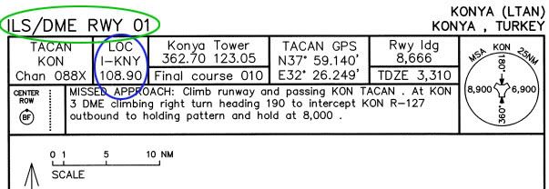
As you can see we have at top left corner (green circle): ILS/DME RWY 01. Also note that Konya has also TACAN station, but the approach is based to ILS navaid for this chart.
After all the above, for Nea Anchialos airbase this is the way that you must do it:
First input the TACAN GPS coordinates (chart gives them) over a steerpoint (STPT) and make it current. Then set the Instr Mode to NAV.
Now you must start the procedure from the IAF (Initial Approach Fix) waypoint (or steerpoint), means from ANL R-153/10 DME at 6,000 ft. (ANL=the ID of the TACAN of Nea Anchialos, R=radial-the course at HSI, DME=NM=Nautical Miles).
Even if you approach the airport from East, you can pass the IAF waypoint and make a turn to heading to it. Also you must manage to reach it with speed of 250 knots.
Then when you are exactly at 10 DME, you must start your left turn to join the 12 DME arc with 30 degrees of bank (and speed of 250 knots) and simultaneously start your descent with 235 FT/NM = 2.2 degrees. Set at HSI course of 117 and when you are at R-117 you must check your altitude and you must be at about 4,000 ft. If you are a little upper or lower you must correct your altitude accordingly. After pass the R-117 you set at the HSI for course 098, which is the LR (Lead Radial=the radial that we starting the turn to the final approach course inbound to airport). So when you are just at R-098, start your left turn with speed of 250 knots and 30 degrees of bank. This guides you over R-090 and at 10 DME inbound to airport with heading 270. At this point and if you have had manage a good descent you must be at about 2,400 ft. Now set at HSI course of 090 (or 270) and continue the descent but from this waypoint with rate of 265 FT/NM = 2.5 degrees while keeping the CDI at the HSI centered. Now the most important section of the approach: You must manage to be at FAF (Final Approach Fix) waypoint (or steerpoint) which is at ANL R-090/6 DME at exactly 1,340 ft. This is very critical, because at FAF waypoint you start the final descent with rate of 265 FT/NM = 2.5 degrees. That means you guide your fpm (flight path marker) just over the 2.5 degrees pitch ladder dive and keep it (the fpm) there until you reach the threshold area. Simultaneously you keep the top of AOA (Angle Of Attack) bracket just to the same level with your fpm (this gives you 11 deg. AOA). At ANL R-090/4 DME you can check your altitude and must be at about 810 ft. If you are not near, you must do minor corrections. Then the last action is to make the final turn to runway, this is done at ANL R-090/2.5 DME and you turn to 260 degrees. At this waypoint you must be at about 420 ft. Then you keep the heading of 260 degrees and you must see the runway threshold area (and if it is night the ALS-Approach Lighting System). If needed you must do minor corrections to your heading and then you have a touch down.
If something goes wrong, you can execute a missed approach (as described in chart) and start a new approach.After all the above, i can say to you that you can use the ILS to approach to RWY 26 of Nea Anchialos if the weather is too bad and you already had missed approach.
So you can follow the TACAN chart until you exit the 12 DME arc at ANL R-090/10 DME and at about 2,400 ft. Then you can insert the LOC frequency which is 110.90 and set the Instr Mode to ILS/TCN or ILS/NAV. Next just keep the ILS bars centered and you will find yourself precisely aligned with runway 26 centerline.So i think now it is more clear the execution of procedure for Nea Anchialos TACAN approach.
If you have any questions, feel free to ask me.
With my regards.
Nikos. -
Gentlemen,
it’s no longer time to say “Deutsche qualitat” only … now we can do the same about the Greek one

Well done once again, Nikos, keep on and high!
Gianni.
-
Gentlemen,
it’s no longer time to say “Deutsche qualitat” only … now we can do the same about the Greek one
Well done once again, Nikos, keep on and high!
Gianni.
Hi Gianni.
Thank you my friend for your kindly words.
With my regards.
Nikos. -
Hi guys.
Well in order to be more helpful, i have include in zip file 2 txt’s with a guide step by step about the execution of each procedure.
(Files: “Balikesir TACAN RWY 01 procedure.txt” and “Nea Anchialos TACAN RWY 26 procedure.txt”).
So anyone who wants, can re-download the zip file from here and get them:
https://www.benchmarksims.org/forum/showthread.php?8426-Aegean-Theater-IAP-chart-Get-and-Test-!&p=120410&viewfull=1#post120410With my regards.
Nikos.It seems me a great initiative. Noobs will be able to learn, the less noobs can reinforce their knowledge and the veterans to consult
")
"I did find myself […] looking into the face of those SA-8s and the two Rolands. My impression of why I survived is that here I am, with the radar cross-section the size of Mount Rushmore, and here are these Iraqi SAM missile operators going, 'Cease fire, Cease fire, don´t shoot! Here´s two dumb Mike Foxes at 20,000 feet and 200 knots-you know, must be Iraqi, hold fire, hold fire!' I think that´s the only thing that saved us"
-
Thanks again, Nikos! Even if it will not be now that I learn it (well “IF” …I’m sure I will at least try)), your initiative is highly appreciated and it reminds me that I want to fly someday in RL: At least a little prop bird.
Cheerio
Thorst.
Stored all your mods…
+1 Top work here! …my dumb/noob-ness is related to the fact that my love sim is IL-2…and I assume one reason is that -even modded- IL-2 1946 requires very little reallife experience with flying and is easier to just tune on…and nevertheless contains a fine feeling of FMs and by now immersive theatres…Nevertheless all of us here already came a long way so why not go a little longer…:) (not that I am a decent pilot, but I like to pretend;)).
-
It seems me a great initiative. Noobs will be able to learn, the less noobs can reinforce their knowledge and the veterans to consult
Totally agree. Well done and thanks a lot once again, Nikos
-
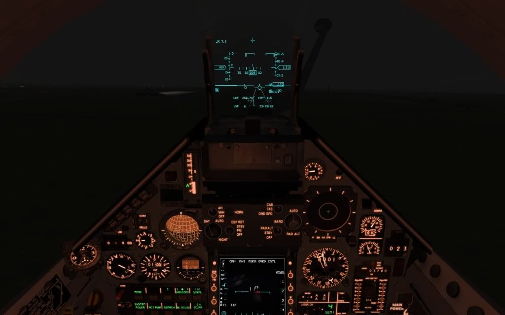
Trying it at night, mid visibility and with light rain…
With M2000
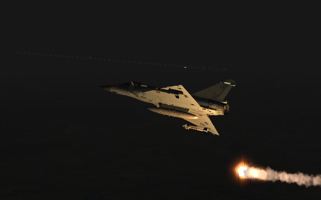
Last moment before the final turn
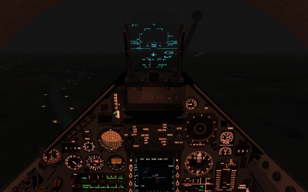
and problems with in short final

"I did find myself […] looking into the face of those SA-8s and the two Rolands. My impression of why I survived is that here I am, with the radar cross-section the size of Mount Rushmore, and here are these Iraqi SAM missile operators going, 'Cease fire, Cease fire, don´t shoot! Here´s two dumb Mike Foxes at 20,000 feet and 200 knots-you know, must be Iraqi, hold fire, hold fire!' I think that´s the only thing that saved us"
