Navigation position Calculator
-
Well guys, let me give you a quick and easy tutorial in order to see and understand the usage of this program.
First let’s see why we need it.
A lot of times you may notice that in some places we haven’t signal from a TACAN station due to around topography of the area (e.g. high mountains). That make our guidance to/from that specific TACAN station almost impossible. That creates the need to use an other way, the GPS coordinates.
So if we can find the GPS coordinates of a specific point, then we can fly to/from it and utilize any possible published procedures.
That need covered by the first section of the program, the “From point A via Radial and DME, find the coordinates to point B.”
Also a lot of times we want to fly from a know point to an other one. But we don’t know the distance between them as also their radial. Both factors are crucial in order to estimate the needed fuel, the time to fly as also the less distance.
That covered by the second section of the program, the “Between 2 known points A and B, find the Radial and DME.”.So in the next example i will use the Israel theater for BMS 4.33 in order to explain the usage.
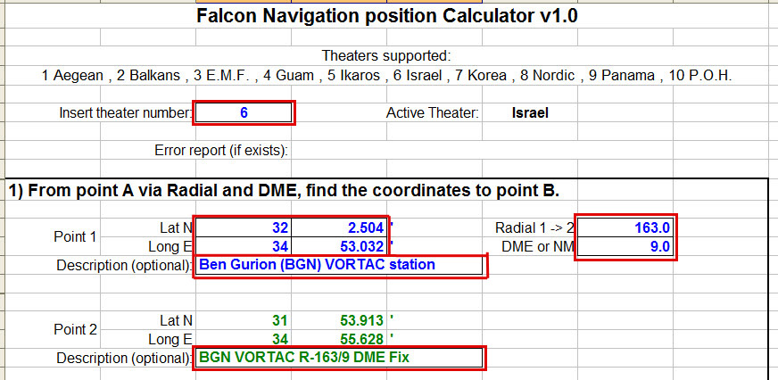
Let’s say as an example (not truth) that in the holding pattern of the ILS procedure to Ben Gurion airport we don’t have signal from the TACAN station. So we must get the GPS coordinates of the Fix that is on R-163 of BGN VORTAC (Ben Gurion TACAN) at 9 DME (or NM). See the photo below:
Now in the program (into Excel), first left click on box that is for theater number and type “6” for Israel theater. Then go and type at the Lat N and Long E boxes of Point 1 the coordinates of the BGN VORTAC, as they are in the chart on top header.
After you type anything, you can hit to “Enter” key or to left click to an other “valid” box in order to apply the insertion of the data. Valid boxes are the boxes that have a border line and can accept input data.
Then insert the Radial that is 163 and the DME (distance in NM) that is 9. Last if you want (it is optional) type a remark for this point, like mine “Ben Gurion (BGN) VORTAC station” in order to know that the previous coordinates are for the specific NavAid (or Fix).
After these inputs you have at the Point 2 the desired coordinates, that are for the specfic point at holding. In the example are N31 53.913’ and E34 55.628’.
See below photo:
Now let’s see the other section, how to find the Radial and DME between 2 know points (means 2 points that we know their coordinates).
So let’s verify at the departure chart of Ben Gurion airport the distance and radial of NATAN Fix from the BGN VORTAC (Ben Gurion TACAN).
See below photo:

Again be sure that you have as theater number the “6” for Israel (else type it), and go to the boxes that are for Point 4. Again after a left click type the coordinates of BGN VORTAC (Ben Gurion TACAN) as they are in the previous chart. Insert if you want a description for this point. Do the same for the coordinates of the NATAN Fix at Point 5 and type a description (also if you want).
When you fill all the boxes, you have the radial (Radial 4 -> 5) and the DME between them, they are 010 (10, the 0 in front meant) and 20 respectively.
Notice that you also have the opposite radial, means from NATAN Fix to BGN VORTAC, it is the Radial 5 -> 4 and it is 190.
Check the below photo:

Last you have for both methods a second point to use, means for the 1st section except the calculated Point 2 in relation with Point 1, you can also calculate the coordinates for Point 3 that is also in relation to Point 1.
In the same way, at section 2 you can calculate the radial and DME for Point 6 in relation to Point 4, except of Point 5 that is also in relation to Point 4.All the basic errors are covered and the user can be informed in order to make the proper corrections via the box “Error report (if exists):” in the top.
Some examples are:I hope to find it useful and make your flight plans more precise.
If you have any questions, feel free to ask me.Nikos.
-
Thank you my friend Nikos, I will study it a lot, because I am always loose in the air, when I am too far from home plate, and sometimes I get shoot from aaa, and loose nav aids in the pit, so, It will enhance my chances to get home without the need to escape from the sim…
I will try it until I learn it.
Regards Metalhead -
Nikos at work –—>


Nice work my friend
Greetings
System Specs: WIN11 Enterprise. Asus Z690-A Prime (DDR5) Intel Core™ i7-12700KF Processor. Corsair H100x 240mm Water cooling. ADATA XPG 16GB DDR5-5200 Lancer RAM, Asus GeForce® RTX 3080 12GB TUF. Kingston NV1 2TB M.2 NVMe SSD HD + WD Blue - 4TB HD. 32" Asus VG32VQ1BR TUF - QHD - 1ms - HDR - 165Hz Gaming Curved main screen - 24" screen for YAME and TM MFD. LogiLink 7+1 USB 3.0 hub, TIR4, Cougar HOTAS FSSB, Saitek Combat Rudder, Viper wing ICP.
-
Thank you Nikos.
-
Hi Nicos,
thank you for this absolut helpfull programmkind regards
Wolfgang (Bazi) -
Hi guys.
Well there is a small update for the program, in order to be more “friendly” for the “coordinates out of limits” error report and can quickly and more easily understand the issue.
So now you can have the min. and max. of the coordinates of each one theater as also its max. DME.
Look at the below photo:

Links for the new version 1.1 at 1st post.
Nikos.
-
After a question, i want to clarify that the Navigation position calculator is conformal for both Balkans theaters, means the one by “cougar56th” for BMS 4.33 and the other one by “nove” for BMS 4.32 (for the moment).
I remind you that also the default Korea as also Israel theaters are conformal in their both versions, means for BMS 4.33 and 4.32.
Nikos. -
Well i got a very good question about the variation that this program have as also its impact to navigation.
Well as i said in 1st post, the max. variation that can have is 0.001’ (minute) in each one value Lat or Long (very-very rare to both of them).
So let’s see what this translates to distance in order to realize how super small is the variation.
In the next example i choose a point with coordinates N39 40.000’ and E23 50.000’. Now i will find the distance of it from the point that has N39 40.001’ and E23 50.001’, means ONLY 0.001’ at each one axis, look at below photo:

You can see that the DME (distance) is 0.0012 NM. I think that it is super small.
And now let’s see with which variations we can have a distance of 0.1 NM, check below photo:

So here we see that with variation of 0.080’ at both axis we have a distance of 0.1 NM.
Probably you should not even see a variation of 0.002’, so be sure that you will have amazing results with this program ;).
Have fun.
Nikos. -
Nikos, you know what I think about you, but I wanna say you again bro: YOU ARE AWESOME. A MILLION OF “THANK YOU” FOR YOUR WORK. This community would be different without you. Hats off and honours for you :woohoo::bowd:
 :headb:
 -
@Tom:
Nikos, you know what I think about you, but I wanna say you again bro: YOU ARE AWESOME. A MILLION OF “THANK YOU” FOR YOUR WORK. This community would be different without you. Hats off and honours for you :woohoo::bowd:
:headb:Haha, it is very nice to see Falcon users so happy like you!
Thank you dear Tommy for your kindly words.
Have fun and if you need extra clarifications i’m always here.
Your friend Nikos. -

"I did find myself […] looking into the face of those SA-8s and the two Rolands. My impression of why I survived is that here I am, with the radar cross-section the size of Mount Rushmore, and here are these Iraqi SAM missile operators going, 'Cease fire, Cease fire, don´t shoot! Here´s two dumb Mike Foxes at 20,000 feet and 200 knots-you know, must be Iraqi, hold fire, hold fire!' I think that´s the only thing that saved us"
-
Hi there guys.
Well a new version 1.2 is out.
Updated the GPS coordinates for Nordic theater to be conformal with the v2.0.
Also minor visual changes for better distinguishing.
Get it from post #1.
Nikos. -
Figure if ‘The Master’ wouldn’t lose the chance to give his own contribution about…
Bravissimo, Nikos!

Gianni.
-
Μπραβο μπραβο μπαβο!!!
-
Thanks, again, for your time and efforts
")
"I did find myself […] looking into the face of those SA-8s and the two Rolands. My impression of why I survived is that here I am, with the radar cross-section the size of Mount Rushmore, and here are these Iraqi SAM missile operators going, 'Cease fire, Cease fire, don´t shoot! Here´s two dumb Mike Foxes at 20,000 feet and 200 knots-you know, must be Iraqi, hold fire, hold fire!' I think that´s the only thing that saved us"
-
Hi there guys.
A new version 1.3 is out for Navigation position Calculator.
In this version added support for theaters Baltic and Vietnam.
Get it from the 1st post of this thread and enjoy it.
Nikos.
-
Great to see you keep that helpfull tool up to date, Nikos.
Thank you!
Cheers, :yo:
LS -
That’s a great job Nikos!!!
Thank you a lot for these supporting things…


