WIP - Guam Theatre
-
BTW this POINT is not a HACK as suggested by some, this DATA edit came from Baldeagle and goes along with the CODE we had\have ATM. So Please M8……SUp about it…TIA
It works…Wrong, it is a CHEAT/HACK when you place it on every single tile in the theater!!! And it’s not a data edit, it’s a fact that was always there!! Don’t try to put it on Fred, he’d never use it in the manner you tell people to!!! He had scruples!!!
Besides, there’s not a thing in your post that isn’t already known.
C9
-
Such a jerk
Vags
-
@Cloud:
Wrong, it is a CHEAT/HACK when you place it on every single tile in the theater!!! And it’s not a data edit, it’s a fact that was always there!! Don’t try to put it on Fred, he’d never use it in the manner you tell people to!!! He had scruples!!!
Besides, there’s not a thing in your post that isn’t already known.
C9
Thank you for your brilliant insight
:bowd:
demer -
example:
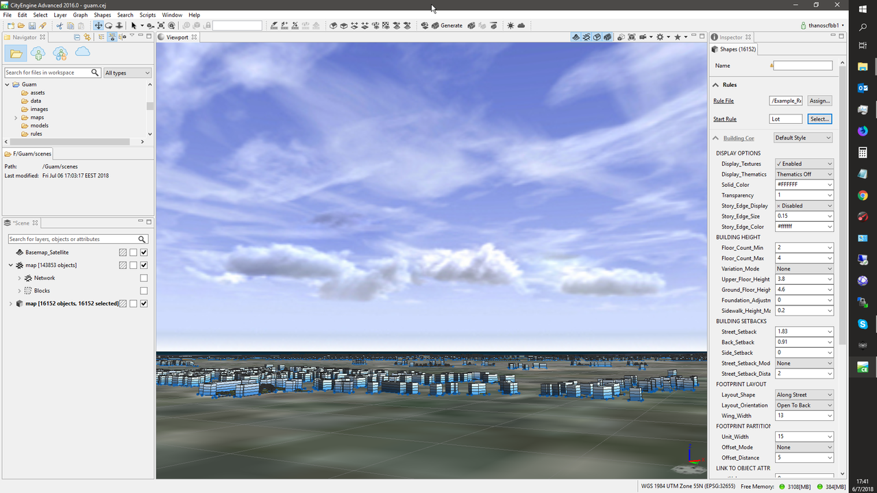
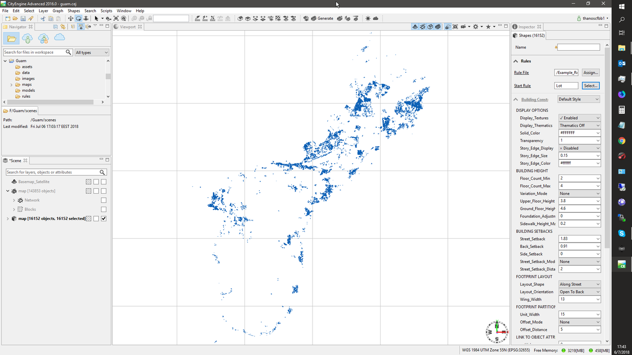
What u see here in blue are the 16000+ buildings that are declared already for the Guam.
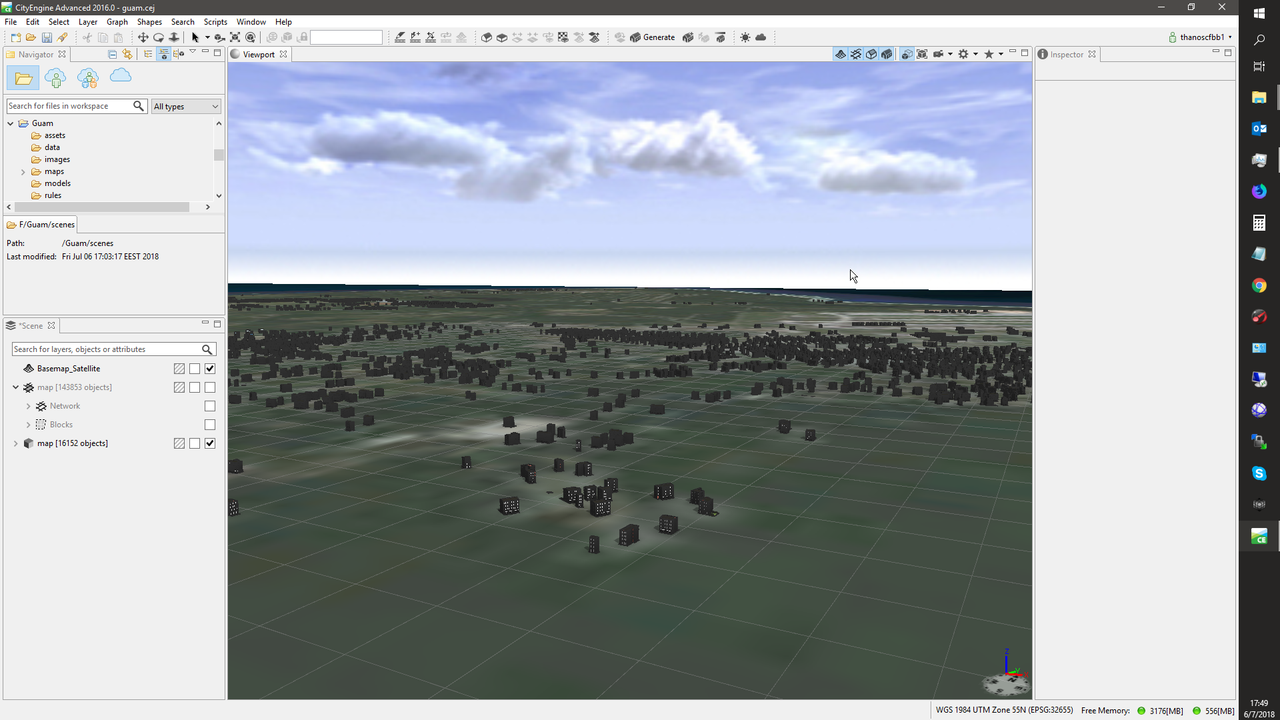
Here are without any heights just flat terrain and demo basic buildings.
HOT LIST

System Specs:
i7-2600K @ 4.8 Ghz WaterCooled / 32GB Ram. 128GB SSD/1TB SSD / GTX1080Ti 11GB DDR5X / HOTAS COUGAR. TrackIR 4 / 3x24" Mon. (res:5760x1200) / Cougar MFD's / Wheel Pedals / Win 10 64 bit.

-
Drop that to 4000 Polys and it is in……LOL!!!
Thanks M8 and per PM we will look at this
") or that
or thatRemember FPS is the key to smooth Game Play……
Kind regards,
demer -
Well the maths are simple.
A building is 5 to 8 polygons.
16.000 buildings are about 100.000.
Now the windows are the Killers to have them night lighted.
So either 5 windows lighted per building will go 5 times more or double than the 100k. U could make the whole building for night with a switch.
Those are going full following real actual buildings count.
You can make just major cities or specific places of interest, near airbases or targets more accurate and the rest generic.
The proof of concept is there, it just needs time.Στάλθηκε από το MI 5 μου χρησιμοποιώντας Tapatalk
HOT LIST
System Specs:
i7-2600K @ 4.8 Ghz WaterCooled / 32GB Ram. 128GB SSD/1TB SSD / GTX1080Ti 11GB DDR5X / HOTAS COUGAR. TrackIR 4 / 3x24" Mon. (res:5760x1200) / Cougar MFD's / Wheel Pedals / Win 10 64 bit.
-
Well the maths are simple.
A building is 5 to 8 polygons.
16.000 buildings are about 100.000.
Now the windows are the Killers to have them night lighted.
So either 5 windows lighted per building will go 5 times more or double than the 100k. U could make the whole building for night with a switch.
Those are going full following real actual buildings count.
You can make just major cities or specific places of interest, near airbases or targets more accurate and the rest generic.
The proof of concept is there, it just needs time.Στάλθηκε από το MI 5 μου χρησιμοποιώντας Tapatalk
New POC, thanks to you:
;0
demer -
HOT LIST
System Specs:
i7-2600K @ 4.8 Ghz WaterCooled / 32GB Ram. 128GB SSD/1TB SSD / GTX1080Ti 11GB DDR5X / HOTAS COUGAR. TrackIR 4 / 3x24" Mon. (res:5760x1200) / Cougar MFD's / Wheel Pedals / Win 10 64 bit.
-
Sooo…it has been a couple of weekends of going through the learning curves of CE\ESRI, what not, with all the Rule’s for Procedural building of Citys ……Sigh…
Guess Nunos has it down and if you attempt this I strongly suggest you contact him!!! Me, I cut the rules to bare min…'cause that’s me…LOL!!!
Here it is…a terrain +buildings+night lighting+real world elevation+Photo Real imagery+++++++AND+NO FPS HIT!!!https://drive.google.com/open?id=1_Mp4gCKmP4TE0BTG0onbH4_czObMI4zY
All done in a few “Spare” hours, which I don’t have much of anymore. But anywho, enjoy and remember what the “Demer” said….FEED YOUR HEAD!!!
Chuckle,
demer
P.S. and yes I know about the Rouge Polygon at the Sandbox…maybe I’ll fix it…or…maybe not…Cheers!!! -
Well done Demer, nice music also. Hmm I believe your age is hanging out.
Vags
-
even though primitive looks nice and alive.
from far in real looks the same.So for faaar lod it could be this without any textures and for close up (and personal) it could be textured or painted.
like facades…HOT LIST
System Specs:
i7-2600K @ 4.8 Ghz WaterCooled / 32GB Ram. 128GB SSD/1TB SSD / GTX1080Ti 11GB DDR5X / HOTAS COUGAR. TrackIR 4 / 3x24" Mon. (res:5760x1200) / Cougar MFD's / Wheel Pedals / Win 10 64 bit.
-
Well done Demer, nice music also. Hmm I believe your age is hanging out.
Vags
Haha, a nice one mate! :rofl:
Nikos. -
Great stuff! Nice Idea- I like it! :drink::high5:
-
Dear Demer, I always knew of your good taste, also with music now… Jefferson Airplane on their first times, am I saying it right? Ehi, guys… that’s still ‘Music’, you know

With best compliments for your choice, Demer, and regards,
-
So another weekend of Falcon……
And onto the next “Land Mass” feature in this Theater…GUAM!!!..
Real Life picNew Terrain pic
As close as I can get……LOL…well not exactly…CE provides you the ability to quickly produce terrain based on Height Maps. As well, it provides you the ability to place buildings (Two Polys if you know how the Rules play, we will make buildings out of them later in the process) at the correct elevation on the Terrain. Also it will export a .dxf of the road network…Hmmm why does demer need that??? That is our “Thousand Point’s of Light” needed to produce the street lights!!!
cheers,
demer -
Sooo……going forward a bit:
Lets just say that CE affords us the ability to create Airports\Airbases at the correct elevation over the terrain? It does. Now, let’s just say that, CE affords you the ability to "SQUASH the mesh to L2 Terrain Height……It does while still retaining kinda L0 elevations……HMMM…??? and lets just say that you can take your beautiful PR image of said terrain and “Slice it into Tiles”…you can. And lets just say you can “Path” the Road Network that comes with CE to your new Tiles over the L2 wireframe that now matches the CE terrain, you can. And what if, lets just say that CE will build Lo-Poly cities\buildings at the correct elevations that work FPS wise in Falcon… it will with the right rules:
Just say’n……
More to come outta’ dis…4sur…
demer -
That’s the spirit…
U can autoplace lamp lights on those streets.
U can also place street furniture… signs trash buckets benches bus stops people cars trees parkings and real streets network, not just the path - place of the streets but junctions and markings on the streets, foot crossings, lanes, directions.
Redlands tutorial and source - example files have all those and how to:
https://www.esri.com/~/media/Files/Pdfs/library/brochures/pdfs/cityengine-example-redlands.pdf


And cause some would say no way Falcon engine can’t handle all those.
Well I don’t believe this will be the issue after Mortesils tool.
U can have a LOD1 with disgusting details (all low poly still, as you see in the images). Maybe 2 versions. One basic for the masses and if your pc can handle it there could be a second version for those.Maybe a structure like high res textures would be nice for the 3D Database… So if you have a killer pc not to go to frenzy to load - import whatever those high poly models but just a selection (for the user) and for the theater creators a different handling or a different folder. So at the same time provide high poly and BMS prerequisites and the user chooses whatever he wants
Hmmm is Mortesil looking??? :lol: we don’t have the basic tool and I keep asking for additions and changes… yea I know I’m crazy… maybe as a structural and for future needs this idea would be better “if” considered a good one or needed to be done from the very beginning as it would mean major database change…
what you save is time…
Yeap airports also… it saves you a great amount of time. doesn’t it?
For special buildings you can build them directly in CE as you have the tools and the underlying photo as reference for size or even the topo map image
http://desktop.arcgis.com/en/cityengine/latest/tutorials/tutorial-14a-basic-polygonal-modeling.htmIf we had a free account to the arcgis database… oh man… the horror!!! :lol: :rofl:
It would be just textures issue and time to import things and stuff objects to Falcon database to death… It would unleash hell :lol:HOT LIST
System Specs:
i7-2600K @ 4.8 Ghz WaterCooled / 32GB Ram. 128GB SSD/1TB SSD / GTX1080Ti 11GB DDR5X / HOTAS COUGAR. TrackIR 4 / 3x24" Mon. (res:5760x1200) / Cougar MFD's / Wheel Pedals / Win 10 64 bit.
-
Interesting stuff…
How do you match RL positional data with Falcon’s fake projections? Are you shifting everything by hand or is there some automated procedure?
And 1 more thing please. Is it possible (As start) to export RL buildings locations from such tool with the following info:
1. Horizontal position - Say in RL LAT/LONG
2. Size (Assume rectangular shapes only, so say X * Y in feet/meters/inches/human-arms/whatever)If yes then how painful can that be to export say a single KTO city/village ?
-
About positioning it to the correct place well no need to ask. u can export the area as image from Terrain Editor (with roads viewable maybe and already falcon objects
) and then you align them. In Demers case u scrap everything from Falcon if it’s just a terrain tile and you place the city where you like. Demer here has the whole island in 3D model so he places the city in the exact correct place as in real.
for heights alignment he can use the already used heights as the ones he used to create the island, but I believe you don’t want that.Edit: look here: https://www.benchmarksims.org/forum/showthread.php?12073-3D-Cities-for-Falcon&p=171102&viewfull=1#post171102
lat long well cityengine uses real ones and you declare which kind so that all your GEO sources to be in synch or while u import sources you must declare the correct one and then it places them correctly.
about the sizes as you ask them well it can export many things but not in the plain context you ask for it.
https://cehelp.esri.com/help/index.jsp?topic=/com.procedural.cityengine.help/html/manual/export/export_toc.htmlThe python report export can give you the XY but it doesn’t state clearly the size dimensions. Have to look in to it.
The XY of the buildings you can get them and from the OSM export. So maybe this is more efficient for Falcon procedural data? Sure ti will need align on the coordinates but this must not be an issue.
How painful is to export a village or a city? Well you can time me. :lol:
Joking.
I can do it for you if you like record it in camtasia and upload the whole process from zero to 3ds max.Pick a city or village of your like and let me know.
Just from rough experience I would say from one hour to maybe a few days. Depends what you want.
The creation and export is not the pain.
The pain factors are preperation:
1. Terrain tiles needs align with jgw
2. Heightmap ok buildings will align perfectly with falcon terrain elevation. Hmm how can I learn max and min height of a theater height map? Sure can do for a town area.
3. Landuse map from gis or manual (industrial urban suburbs center skylines)
4. Obstacle map from terrain editor with objectives features view or manual. That way falcon buildings will blend naturally. Also sea lakes rivers and falcon roads will be perfectly respected.
5. Roads network from OSM ( consider dxf for grouping - separating areas to easily import and manipulate in Falcon) reminder: maybe from QGIS will work.
6. Landmark buildings from free models, must blend with obstacles map or manual edit.
7. Facades must be square, maybe I should talk with WaveDave and review his remarks on texture materials. Must create one set per Landuse. Also one extra set for each for night.
8. Rules per Landuse per day night?
9. 3d Roads must not be used. (for poly count reduce, or they can be used as a separate feature)
10. Destroyed models.Now the most painful is the textures library and the rules.
if you want to more easily transfer them and not render to texture in 3ds u must create the library as squares and use this in CE. CE exports and the uvmapping and materials. Doesn’t use dds but I believe this will not stand in the way. maybe even and with a script in 3ds max you can make the mass switch.
Rules are kinda simple once you get used to them. Sure you will have some places that things will look strange but those are minimal and depend on the source detail. For example in Guam you have each building place. For my home town you have the whole block of buildings. This is good and bad.
if you have the exact buildings brake down (LOTS) then its good for realism and eyekandy but results to actual number of buildings which might mean too many buildings.
if you don’t have the exact buildings LOT but one LOT for the whole block meaning like 10-15 buildings per block you can have like 5 to 10 which is bad for realism but lighter for the gfx.Still on both you can have the correct real streets network.
Now if we have to respect the falcon roads network (for the known reasons) u have to draw them (easy the are not so complicated and you can have the image underneath as reference) (maybe if the source exists can be imported?).
For the heights u can export them from Falcon and use it in CE… CE has an option when it creates the models to snap them to the terrain. Ofcource if you done it in real height data and then do it like that (falcon Heights) well makes you laugh cause it looks ridiculous.
HOT LIST
System Specs:
i7-2600K @ 4.8 Ghz WaterCooled / 32GB Ram. 128GB SSD/1TB SSD / GTX1080Ti 11GB DDR5X / HOTAS COUGAR. TrackIR 4 / 3x24" Mon. (res:5760x1200) / Cougar MFD's / Wheel Pedals / Win 10 64 bit.
-
You have gone too far

I don’t need 3D objects created… I only need data, e.g like in or similar to the format I posted above. But since you said OSM should be easier for that, then I guess that’s what I need.
But, I guess the main problem is projection, as I need a special one. Not Falcon fake projection, but also not that popular Google style projection… I actually need to check that. So NM for now.
Thanx!
")
