NTO Polar Vortex V2
-
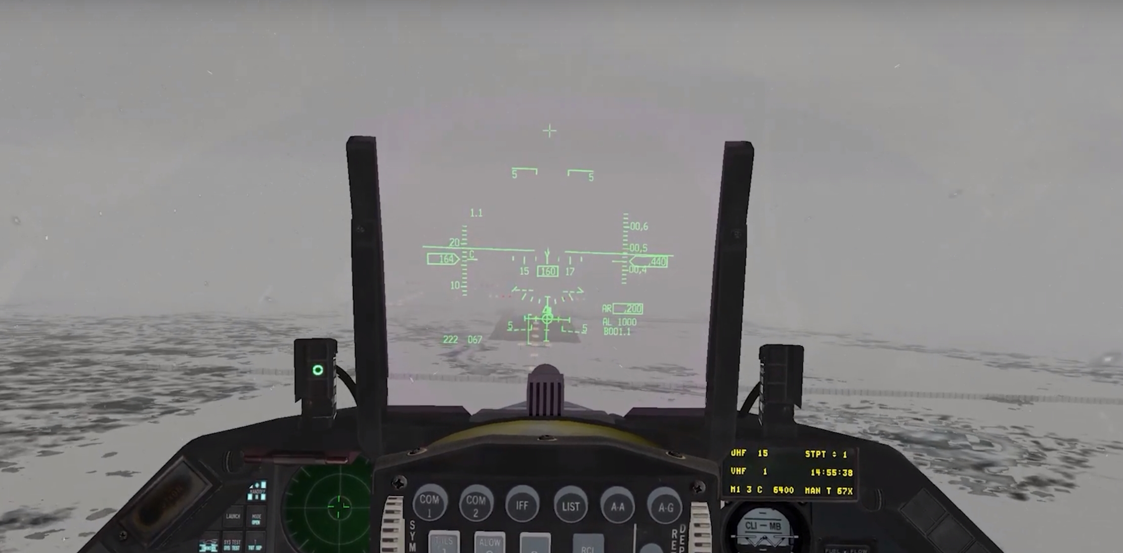
We have gotten some awesome missions out of these new campaigns. Flying out of Bardufoss in the mountains is ultra cool. I’m using winter textures with lots of snow and clouds.
ILS show its power.
")
Nikos. -
speaking of ILS, I made another approach chart: for Bardufoss. Tried a DME arc this time.
Just good enough to do the job until a pro like Nikos puts them out

-
Thank you for your kind words mate.
Well after some scheduled works, beautiful Nordic theater is on my list.
So yes, you will have some more nav. charts for sure!
Nikos.
-
speaking of ILS, I made another approach chart: for Bardufoss. Tried a DME arc this time.
Just good enough to do the job until a pro like Nikos puts them outHey gza, that looks pretty good. Do you have some kind of generator or template for these charts or do you just work very tidy?
-
@TwanV:
Hey gza, that looks pretty good. Do you have some kind of generator or template for these charts or do you just work very tidy?
thanks man, I like tidy
I use these charts as templates:https://avinor.no/en/ais/military/milproc
https://avinor.no/globalassets/_microsite/ais-portal/mil/endu/en_ad_2_endu_304hitac28_en.pdfedited them with adobe acrobat. But that was becoming clunky so I finished it with paint.net or photoshop
-
I’d be more interested to know about Nikos’ process. Like where does he get the bms elevations, exact positions of the navaids etc
He puts out entire volumes… just look at the Nordic, ITO, and Balkans MAIP.
I imagine he has some kind of professional experience. -
I’d be more interested to know about Nikos’ process. Like where does he get the bms elevations, exact positions of the navaids etc
He puts out entire volumes… just look at the Nordic, ITO, and Balkans MAIP.
I imagine he has some kind of professional experience.Well my friend, here some infos, no secrets here

- About elevations, get them into the F-16 cockpit with baro for altimeter.
- Exact position of NavAids (means their GPS coordinates) can get from the STPT 1 (steerpoint) when they are the default terminal ones. If there are enroute NavAids, you can use Mission Commander for their GPS coordinates.
- The rest data can be retrieved from the file “stations+ils.dat”, means TACAN channel, its band and range, ATC frequencies and ILS frequencies.
- About Nav. volumes, there are also for nice POH theater and of course the “monster” Aegean stuff with Enroute charts also.
- Last about professional experience, yes. I was served here in Hellas (ex Greece) at the position of Radar Operator (military ATC) for 14 months. So a lot of real rules and stuff into my hands. This in coordination with the fact that I’m a civil engineer, makes me very strong to create this stuff.
My charts have been always created via the professional program Autodesk AutoCAD and are under scale, that makes them the best you can have!
As a note, I can tell you that it is inaccurate to get a real nav. chart and change some things (numbers/data) in order to think that you bring it close for use into Falcon BMS theaters.
The side of the NavAid in relation with the RWY, its distance from RWY threshold, the angle between the RWY centerline and the line that connects RWY threshold and NavAid are only a few things that should be exactly the same in order to can “edit” a real chart ;).
Even a variation of few degrees at the angle and you have a complete different inbound final radial.
The same counts for the GlideSlopes. In real life are not all the ILS procedures with a 3.0 deg. descent. In Falcon they are. That means that you have variations at the distance (DME) for the same altitudes!After all the previous, your ONLY way to have a “valid” perfect/safe procedure is to create it from scratch.
Nikos.
-
Merry Christmas and Happy New Year!
/StenneG
-
Well after some scheduled works, beautiful Nordic theater is on my list.
So yes, you will have some more nav. charts for sure!
Nikos.So, just can’t await (on my side).
With best regards,
Gianni.
-
How can I get this to run with WDP?
Everytime I try to open my campaign save with WDP it says that it belong to nordic theater and my falcon install is set to “NTP Polar Vortex”.
When I say yes to change to nordic and after manually pointing to nordic.idx and nordic.wch files I see the scheduled flights and select mine.
But in the back I get the Korea Map in WDP. So it’s useless for flight planning.
-
WDP does the same for me, I load the save file as you do including pointing to the files .idx and .wch, select Nordic from the drop down list on the top left corner of the WDP window and go through the process of pointing to the files again. I select again the flight from the package using select different flight, at this point you should have the correct map displayed.
Cheers
Luke
Sent from my SM-T820 using Tapatalk
-
Thanks,
I’ll give it a try.
-
here’s a mission we flew a couple weeks ago, the AI has been fragging wave after wave of OCA strikes against our airbases
they’ve got us on the ropes at the moment -
Hi Luke777, Are there documents for cockpit procedures of the JAS 39 Gripen?
-
I thought there was a file in the DOCS folder, can’t check that at the moment.
Cheers
Luke
Sent from my SM-T820 using Tapatalk
-
There werent any under the DOCS folder, also searched the complete Theater folder for it but nothing
-
I’ll try to find out. Will get back to you.
Sent from my SM-T820 using Tapatalk
-
@WurminatorAZ
JAS39 uses JAS37 cockpit from standard KTO, you can find the cockpit diagram in the KTO DOCS folder.
Sent from my SM-T820 using Tapatalk
-
Polar Vortex 2.4 :thumb:
https://www.mediafire.com/file/ux4kvo9grbvb8yb/Polar_Vortex_2.4.7z/file
has Scorpion’s updated Euro-fighters gbu48 and 49. there is a change log in docs for this
ch53 update (damage levels)
su34 FM update (tgp)
Luke renamed all “no where” objectives
and updated cam files.
Fixed (null) oob glitch
I can let him elaborate better on first postCheers
-
First post updated
Sent from my SM-T820 using Tapatalk