Guantanamo Theater
-
the thing is first to be sure what the tdf has in regarding the points. u say it has 2 points per road? then those are a line start end. I can’t think of anything else.
doing this from excel might be harsh.
roads from GIS are super uber detailed and they can be normalized or if you prefer reduce the points.So who knows and can document what the source needs or the file format.
does it exist in PMC?Each “part” of a road in the tdfs haves various points from 2 to 10 maybe 20… what i mentioned (and i will edit) as 2 was just an example.
You might see in a tdf : ROAD 2 X,Y X,Y 0 that is 2 points at x,y and x,y 0 probably is the end of that part. in the next line u might see 8 x,y x,y x,y… and so on…
On an exported csv from a qgis layer you will see from 0-x number of points each one with their X,Y coordinates but it will start from 0 and end at 1 (2 points) or 0 (for the next part) and end at 10 (11 points) -
Each “part” of a road in the tdfs haves various points from 2 to 10 maybe 20… what i mentioned (and i will edit) as 2 was just an example.
You might see in a tdf : ROAD 2 X,Y X,Y 0 that is 2 points at x,y and x,y 0 probably is the end of that part. in the next line u might see 8 x,y x,y x,y… and so on…
On an exported csv from a qgis layer you will see from 0-x number of points each one with their X,Y coordinates but it will start from 0 and end at 1 (2 points) or 0 (for the next part) and end at 10 (11 points)come again I don’t follow…
-
Watch out. Roads ≠ Links.
Links just link (doh) objectives. To be linked they should have a road that go from one objective to the other, BUT not all points on a road will point( doh again) to an objective. There are probably more points on that road that do not signal any objective.
If the pourpouse of the qgis extraction is ti make a new roads tdf, fine. No problem. This tdf will be used for UI map and tiling. If the pourpouse is to have a way to automate links, this will need some (quite some) work .
cellphone
-
IMHO It would be easier to have the data exported/converted as e00 to let Dem2Terrain do the conversion to X/Y tile coordinates.
cellphone
-
come again I don’t follow…
Ok,
TDF: point A to B the text is like : Road 2 122,1234 123, 1234 0
exported
CSV: Point A to B is like 0 122 1234
1 123 1234
On both from A to B might be more than 2 points so text will continue in the tdf till point 0 (end of the road part) as many times as its needed so it will in the exported csv as well
to the text it will be as : ROAD 10 (lets say 10 points to a part) 122,1234 123,1234 123,1235…… 0<------end of the part
to the exported csv will start as 0 (several other info in between) 122 1234 and then it will continue on the next row 1 123 1234 until it gets to 10th row that will be the end of the part -
IMHO It would be easier to have the data exported/converted as e00 to let Dem2Terrain do the conversion to X/Y tile coordinates.
cellphone
Dem2terrain is old and it has wrong projection of the world… For now is good but im afraid that soon will be obsolete as the e00’s as well are way too old and inaccurate. Actually the whole D2T and e00 its innacurate but its the only tools we can work with for now. Roads do mean paths. Whatever link you have if you dont have paths in your THR file then units dont move… unless you have all your tiles pathed as roads witch means innacurate (again) and that G.U.s can move over whatever terrain either that i road tile,river tile,rocky tile etc… its a way to go also but then no difficulties on gaining some objectives… Also i think that more paths gives you more freedom to link objs between them and also to MC to auto link
EDIT: Also we have an opportunity to have better sources on making a theater and way more accurate than something is almost 18 years old i believe
-
I cant explain it better i think!

-
it can be automated in excel easily.
The excel came from qgis?
how?if from qgis and gis data, most probably it will be doable to get the same format and have all points of a “segment” of the “vector” in one line.
HOT LIST

System Specs:
i7-2600K @ 4.8 Ghz WaterCooled / 32GB Ram. 128GB SSD/1TB SSD / GTX1080Ti 11GB DDR5X / HOTAS COUGAR. TrackIR 4 / 3x24" Mon. (res:5760x1200) / Cougar MFD's / Wheel Pedals / Win 10 64 bit.

-
oh and e00 is dead long time… R.I.P.
HOT LIST
System Specs:
i7-2600K @ 4.8 Ghz WaterCooled / 32GB Ram. 128GB SSD/1TB SSD / GTX1080Ti 11GB DDR5X / HOTAS COUGAR. TrackIR 4 / 3x24" Mon. (res:5760x1200) / Cougar MFD's / Wheel Pedals / Win 10 64 bit.
-
Please, everybody, I understand that you are trying to make the magic of getting the data from other sources. I am more than ok with that, I do support you.
What I was saying is that, as long as you have a Dem2Terrain generated terrain (.l2 and .o2), I think is better to make the new data into .e00 format for Dem2Terrain to work It out therefore your new data matches your not so perfect terrain. ( It might not be perfect, but is quite acurate, I must say. Wrong is not the word I would use.)
I think you all misunderstood me. I am not saying to stay using the legacy .e00 data, but to convert the new data into .e00 format.
cellphone
-
We already getting the data the thing is to inject that data to current falcon terrain (for me at least). Cate is tiling a theater based on the heightmap of the theater… what that means? that whatever the l2 you have you can transform it in whatever theater you want as long as your data is the same segments how? by terrain editor and mod theater function…Monster very well explains in the documents online how u can use a real height map (witch guess what,u can also have through qgis
") ) and as long is 64seg for example you can inject it to the theater. ther “prepare” it with cate and your basic theater is ready. Here comes the tdfs and cate u need those tdfs if you want to get easy and fast and not take months/maybe years tiling the theater by hand. (with even in that you need the tdfs to guide you) so if theres a way to get new tdfs then we dont need the e00’s. As arty said are dead long time now. I think its time to move ahead a bit. Im not saying is bad to use e00’s but its better if we can use new technology (thats is available now) and what is available to us right now and make our life easier. The whole world works with .shp and other formats and we keeping e00s that the latest we can get are from 2006 if i remember correct. Again its not bad but we can have the power and programs to get better
) and as long is 64seg for example you can inject it to the theater. ther “prepare” it with cate and your basic theater is ready. Here comes the tdfs and cate u need those tdfs if you want to get easy and fast and not take months/maybe years tiling the theater by hand. (with even in that you need the tdfs to guide you) so if theres a way to get new tdfs then we dont need the e00’s. As arty said are dead long time now. I think its time to move ahead a bit. Im not saying is bad to use e00’s but its better if we can use new technology (thats is available now) and what is available to us right now and make our life easier. The whole world works with .shp and other formats and we keeping e00s that the latest we can get are from 2006 if i remember correct. Again its not bad but we can have the power and programs to get better ") Anyway. we said enough off topic… Sorry for hijacking your thread BW… i can explain stuff you know where u can find me
Anyway. we said enough off topic… Sorry for hijacking your thread BW… i can explain stuff you know where u can find me
Cheers -
Guys,.on a BMP pass on CATE the tile textures are assigned with an X offset of +68 if I overwrite the Theater.l2 or +12 if I save to a different name like i.e. “newTheater.l2”
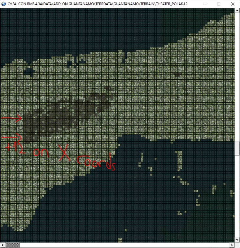
Does anybody know why this is happening or how to overcome? My bmp file is fine as I have used other colors for a different area without problems
my conf file:
# Place base deep ocean tiles introducing variation.
# Further variation will follow.

BMPFileName=C:\Users\AlfonsoP\Documents\Escuadron111\Herramientas\CATE_v4.17_+stuff\CATE_configs\Guantanamo_index3.bmp

[Rules: BMP Forest]
Color=50,100,50

ForceFog=* * *

TileRule=0    100000    (*)    (116,256,257,258,259,260,261,644,1904,1920,1955,1983,2200)    * * * *

[EndRules]

# EOF
i have tried both with this:
and this (actual conf belongs to this one, I also changed colors just for trying to solve it)

since postimages changes my format, I have uploaded them here -
Guys,.on a BMP pass on CATE the tile textures are assigned with an X offset of +68 if I overwrite the Theater.l2 or +12 if I save to a different name like i.e. “newTheater.l2”
Does anybody know why this is happening or how to overcome? My bmp file is fine as I have used other colors for a different area without problems
my conf file:
# Place base deep ocean tiles introducing variation.
# Further variation will follow.

BMPFileName=C:\Users\AlfonsoP\Documents\Escuadron111\Herramientas\CATE_v4.17_+stuff\CATE_configs\Guantanamo_index3.bmp

[Rules: BMP Forest]
Color=50,100,50

ForceFog=* * *

TileRule=0    100000    (*)    (116,256,257,258,259,260,261,644,1904,1920,1955,1983,2200)    * * * *

[EndRules]

# EOF
i have tried both with this:
https://i.postimg.cc/JDN82fP3/Guantanamo-index2.png
and this (actual conf belongs to this one, I also changed colors just for trying to solve it)
Try what i told u after making the bmp open it with paint and save it again. That did the trick on me. I had the same problem in NAM. And try also having different passes. Dont have all colors in one pass only and only with real RGB colors that might help also. Use exact pallette when saving bmp otherwise the colors get porked. From 256.256.0 might have 255.256.1
Στάλθηκε από το SM-G970F μου χρησιμοποιώντας Tapatalk
-
will try, I have not saved with paint but I did open it with paint to check the rgb numbers of the area. I only do one pass for one color.
EDIT: tried opening and saving with paint, didn’t solved it.

-
will try, I have not saved with paint but I did open it with paint to check the rgb numbers of the area. I only do one pass for one color.
EDIT: tried opening and saving with paint, didn’t solved it.
Try to shorten your .bmp file name to a 8+3 style, we are working with old tools here
so that might help. (similar for .L2/.O2 IMHO)Else, the error must be in your .bmp or your script.
Sidenote: Variations should be done last.
You’ll have a hard(er) time to write transitions and RR, etc. scripts for all those
variations you already have.IMHO better keep it simple as possible to create the crucial features like RR, cities and airbases
first, then make it pretty after.
Cheers, :yo:
LS -
For now this project is on hold until Spain-Portugal-Maroc-Algeria theater (Pillars of Hercules) is updated to 4.35.
Sorry people, I Will get back yo this ASAP.
cellphone
-
Sounds fair and reasonable that, BlackWolf.
I can wait (and await too
 ).
).With best regards.
-
For BMS 4.35 ?
-
I can’t guarantee. It’s hard to maintain 1 theater up to date.
Imagine two theaters for one person.
Anyway, If I ever leave the project I will release what I have before. And hopefully that would be at least flyable.
Enviado desde mi SM-A715F mediante Tapatalk
-
Some good people is giving a hand on this project. I am grateful for that.
Hopefully Guantanamo 4.35 will happend.
Enviado desde mi SM-A715F mediante Tapatalk
