WIP - Libya BETA for BMS
-
Me thinks it’s a mismatch between GIS and DEM2terrain projection methode.
DEM2terrain output is Sinusoidal projection with WGS1984 Spheroid.
(Thank’s to “Lukas” who posted this on PMC forums.)That’s exactly true and I was looking for the correct terminology before I responded so Thanks LS.
There’s going to be a difference in the comparison.
RAM22
-
Me thinks it’s a mismatch between GIS and DEM2terrain projection methode.
DEM2terrain output is Sinusoidal projection with WGS1984 Spheroid.
(Thank’s to “Lukas” who posted this on PMC forums.)Cheers,

LSEverything I’ve imported in GIS is set to WGS84. Even my nasa imagery matches up correctly with real world coordinates, even my 16bit greyscale 250m elevation data matches up perfectly, and my vegeatation/groundcover data matches up perfectly.
So, how do I go from WGS84 to that mumbal jumbal that you speak of?? I don’t like DEM2terrain, don’t know why all of these theater creaters are so set on it. What’s it needed for anyways? I thought I’ve read somewhere about it being used for the raw output, if that’s the case, why not just use the original nasa stuff from the get go?
EDIT: By the way, sorry for all of this confusion, I finally smarted up and compared some of the other stuff out there on the web and these coordinates have not been changed, lol, lol, man……
-
It’s the only tool available to generate a theater into Falcon format from the STRM and E00 data available.
Whether you like it or not is irrelevant. You shall be assimilated!!!
RAM22
-
EDIT: By the way, sorry for all of this confusion, I finally smarted up and compared some of the other stuff out there on the web and these coordinates have not been changed, lol, lol, man……
You don’t say!!! LOL
RAM22
-
Everything I’ve imported in GIS is set to WGS84. Even my nasa imagery matches up correctly with real world coordinates, even my 16bit greyscale 250m elevation data matches up perfectly, and my vegeatation/groundcover data matches up perfectly.
But it seems your DEM2terrain generated map don’t match anyway.
So, how do I go from WGS84 to that mumbal jumbal that you speak of??
It’s an export option in “Global Mapper” software,
but I was not able to epxort a complete map for a 128 seg. theater due to memory issues.
So I’ve just exported some feature data for lakes.Maybe you’ll be lucky and can export a complete map for a 64 seg. theater.
I don’t like DEM2terrain, don’t know why all of these theater creaters are so set on it. What’s it needed for anyways? I thought I’ve read somewhere about it being used for the raw output, if that’s the case, why not just use the original nasa stuff from the get go?
What Brian said.
")
Cheers,

LS -
-
Don’t have the global mapper plugin… I’ll search around sometime to see what others have come up with but I’m not really familiar with Qgis and all of these coordinate systems so it’ll take some time.
If that fails than the other option for me would be to just find out what the real world coordinates are in wgs84 and than tweak the image in photoshop to match her up.
Thanks for the input and help fellows!
-
Thanks for the input and help fellows!
No thanks required, I’m here to help make your life miserable!!! :lol:
Brian
-
@RAM22:
Sorry, but no. That would require a whole new theater generation and I’m not willing to do that at this point in the game. Most objectives are already set in the te_new and campaign file and they would all have to be redone.
King Richard works on the terrain textures along with me, he doesn’t do theater generation or campaign files. He’s an Arteeest!!! LOL Well he does have other skills but they are secret at the moment. HAHA
RAM22
Rgr that, no need to excuse yourself. Just asked if it is possible/reasonable. Good luck with the development, looking forward to it!
-
Don’t have the global mapper plugin… I’ll search around sometime to see what others have come up with but I’m not really familiar with Qgis and all of these coordinate systems so it’ll take some time.
Good luck.
If that fails than the other option for me would be to just find out what the real world coordinates are in wgs84 and than tweak the image in photoshop to match her up.
I’ve also tried to tweak the map images in photoshop to match her up, … and result was bad.
… Good luck again.Cheers,
LS -
your projection is not defined just by “wgs84” (it is a description of the volume, you are projecting on)….sinusoidal is the type of the projection and the central point is important as well…it is not so important, what is your corner coordinate…the central lat lon is the most important imho
BTW it is quite some time now, since i posted that projection info on PMC…nobody told me that, i had to make a lot of tests…I used various freeware and payware programs (even some online, web based apps - worked fine) for tests…If the program supported sinusoidal projection over WGS84 (or was able to support custom proj. configs), the result exactly matched DEM2terr output…so still, I think it was correct info…
Luk -
@RAM22:
No thanks required, I’m here to help make your life miserable!!! :lol:
Brian


Cheers,
LS -
Chaps remember I made an offer for textures, some kickass desert ones among those.
I am too lazy and to uninterested in BMS today (IL-2 day all the way) to read through here, but pm me if you wish.
I already sent a bunch of tex to Cemil, master of 3Ds…Chrs
Thorst.
-
PS: Not disinterested in general, only I work in 2 Beta teams and already skipped one of it ATM so I split between BMS days and IL-2 days and usually IL-2 wins.:D
But BMS rocks nevertheless…one of the reasons I love IL-2 so much is that I can fly in like 20 -30 kickass theatres…so…Good Luck chaps, theatre making is what will extend this sim. -
I’ve also tried to tweak the map images in photoshop to match her up, … and result was bad.
… Good luck again.lol, alright so I’ll stick to trying to sort this thing out within gis, I did a very small search on it and seen some others conversating about how to do it, bunch of unknown lingo that they were throwing around but it appears to be possible. It’ll just take a bit to understand some of the things in gis and it’s scripts.
your projection is not defined just by “wgs84” (it is a description of the volume, you are projecting on)….sinusoidal is the type of the projection and the central point is important as well…it is not so important, what is your corner coordinate…the central lat lon is the most important imho
BTW it is quite some time now, since i posted that projection info on PMC…nobody told me that, i had to make a lot of tests…I used various freeware and payware programs (even some online, web based apps - worked fine) for tests…If the program supported sinusoidal projection over WGS84 (or was able to support custom proj. configs), the result exactly matched DEM2terr output…so still, I think it was correct info…
LukI have no idea how the projection works but I did change the transformation type to “projection” while using georeferencer to import the image from the theater and that definitely lined things up better. I believe there’s ways to set up a custom projection within gis as well but again, I’m very new to gis so I’ll have to read up on it. Big thanks for pointing me in the right direction!
I really hope to nail this down, it’d allow me to create some sat image reference photos of the theater to pop into TE as well. Having the theater preview show exactly what should be there would be a huge help.
Chaps remember I made an offer for textures, some kickass desert ones among those.
I do remember RAM linking me to some stuff that you showed him some time ago, the problem was that the textures weren’t appropriate for 1x1 tiles. But yes I have seen some really nice work done in il2 but the way that sim handles the ground textures is not the same as falcon. I do appreciate the kind gesture though!
-
This is from the .hdr for the 64Seg:
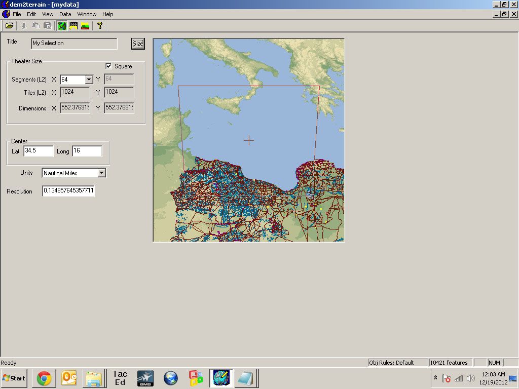
This is the outputed Theater file:
Theater name: My Selection
Theater size: Regular
Size (L2 segments): 64 x 64
Size (L2 tiles): 1024 x 1024
Size (Nautical Miles): 552.377 x 552.377
Resolution: 0.134858 Nautical Miles
Centered on: Lat 34.5 Long 16
NW: Lat 39.1031 Long 10.0682
NE: Lat 39.1031 Long 21.9318
SW: Lat 29.8969 Long 10.6903
SE: Lat 29.8969 Long 21.3097
Highest point: 10354ft
Lowest point: 0ftThis is the outputed Theater file when i first tried to change it to 128Seg:
Theater name: My Selection
Theater size: Regular
Size (L2 segments): 128 x 128
Size (L2 tiles): 2048 x 2048
Size (Nautical Miles): 1104.75 x 1104.75
Resolution: 0.134858 Nautical Miles
Centered on: Lat 34.5 Long 16
NW: Lat 43.7063 Long 3.26464
NE: Lat 43.7063 Long 28.7354
SW: Lat 25.2937 Long 5.81752
SE: Lat 25.2937 Long 26.1825
Highest point: 10354ft
Lowest point: 0ftLOL!!! Guess Dem2Terrain didn’t like that much!!!
It shifts it a bit by ##.xxxxx it seems.
No biggy IMHO unless your using some tool to tile that need’s Precise Coord’s for placement like in ****dSX…LOL!!
Can’t remember which Seg theater i gave you guy’s,but both were built on the new coords.
You can check this easily by trying to fit the original Coast tile’s i made or Mapi’s island tiles to SM’s theater…won’t worktired demer
-
…If the program supported sinusoidal projection over WGS84 (or was able to support custom proj. configs), the result exactly matched DEM2terr output…
LukLukas, can you tell us please which programs you’ve used?
Cheers,
LSmy Rig:
Alienware "Aurora" I7-960 3,2 GHz / 18 GB DDR3 / GeForce 1070 GTX 8GB /
1x500 GB SSD / 1x2 TB SATA II (1x1,5 TB SATA II for backup)
Hotas Cougar Nr.:16387 / FCC-3 / Elite Rudder pedals / TrackIR4 / Win10 x64 Home -
This is the outputed Theater file when i first tried to change it to 128Seg:
Theater name: My Selection
Theater size: Regular
Size (L2 segments): 128 x 128
Size (L2 tiles): 2048 x 2048
Size (Nautical Miles): 1104.75 x 1104.75
Resolution: 0.134858 Nautical Miles
Centered on: Lat 34.5 Long 16
NW: Lat 43.7063 Long 3.26464
NE: Lat 43.7063 Long 28.7354
SW: Lat 25.2937 Long 5.81752
SE: Lat 25.2937 Long 26.1825
Highest point: 10354ft
Lowest point: 0ftI just checked out these coordinates and these are definitely not the coordinates of what RAM and I have. The older coordinates that RAM posted a bit back are the ones that fit, and I’m sure of it now that I’m aware of the spherical projection used during the creation!
Lukas, can you tell us please which programs you’ve used?
Cheers,
LSBumping this so it doesn’t get skipped!
-
I just checked out these coordinates and these are definitely not the coordinates of what RAM and I have. The older coordinates that RAM posted a bit back are the ones that fit, and I’m sure of it now that I’m aware of the spherical projection used during the creation!
Bumping this so it doesn’t get skipped!
Then i have no idea where that map came from?!?!?!
L2 and the rest of the Terrain File’s should be dated 10/15/2011 if they came from my rebuild.tired demer
P.S. Are the City\Airport Objectives sitting on the correct tile’s ???
-
