How to start Theater development
-
reading a lot today for hours about developing your own theater, I have an idea for an theater that I want to develop but how to start?
I downloaded various tools such as dem2terrain… when I go to http://www.ngdc.noaa.gov/cgi-bin/mgg/ff/nph-newform.pl/mgg/topo/customdatacd, I do get an error and cannot download DEM data. Has this been moved or how to get the data???
thanks
-
A simple Google “dem data download” search might help you I believe
HOT LIST

System Specs:
i7-2600K @ 4.8 Ghz WaterCooled / 32GB Ram. 128GB SSD/1TB SSD / GTX1080Ti 11GB DDR5X / HOTAS COUGAR. TrackIR 4 / 3x24" Mon. (res:5760x1200) / Cougar MFD's / Wheel Pedals / Win 10 64 bit.

-
Old GTOPO30 data (tiles) are still available under GLOBE Project or under USGS Earth Explorer interface. The problem is that they no longer have HDR file and this is why they are no longer fully and straight forward DEM2Terrain compatible. Dem2Terrain needs to be modified to be able to use that data.
So … perhaps it is time to bite a bullet and move to SRTM data:
http://www.cgiar-csi.org/data/srtm-90m-digital-elevation-database-v4-1 -
hmmm could this way see the falcon elevation in real GIS programs?
http://www.qgistutorials.com/en/docs/working_with_terrain.html
HOT LIST
System Specs:
i7-2600K @ 4.8 Ghz WaterCooled / 32GB Ram. 128GB SSD/1TB SSD / GTX1080Ti 11GB DDR5X / HOTAS COUGAR. TrackIR 4 / 3x24" Mon. (res:5760x1200) / Cougar MFD's / Wheel Pedals / Win 10 64 bit.
-
reading a lot today for hours about developing your own theater, I have an idea for an theater that I want to develop but how to start?
I downloaded various tools such as dem2terrain… when I go to http://www.ngdc.noaa.gov/cgi-bin/mgg/ff/nph-newform.pl/mgg/topo/customdatacd, I do get an error and cannot download DEM data. Has this been moved or how to get the data???
thanks
-
thanks a lot, thats what I needed… this link saves the day!
-
Haha, Joe has downloaded DEM data of the whole world.


… and IIRC C9 did the same for feature data.
")
Cheers,

LS -
what theater?
-
I downloaded whole world by JL, but cannot open it in Dem2Terrain. Any additional trick necessary?
-
-
I downloaded whole world by JL, but cannot open it in Dem2Terrain. Any additional trick necessary?

No, … works fine here.Cheers,
LS -
I downloaded whole world by JL, but cannot open it in Dem2Terrain. Any additional trick necessary?
Simply open HDR with D2T
-
strange…I can not open it too…I did wait 10 minutes and nothing was visible
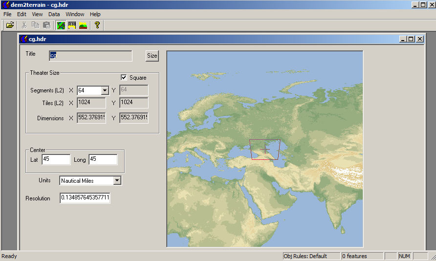
I have win7 64bit, 8GB RAMbut I am able to open my own, smaller merge (cg.hdr file is loaded and visible in second…)
Edit:
BTW I was able to stitch data in one column…but unable to stitch them in the row in the past…
So i did many thin rows(upto the site filesize limit) to get cg.hdr…and another for England-Greenland-USA…I had to stitch these two files using photoshop in the past…so I like your big “whole world merge”…but can not load it (win764bit is my guessed troublemaker) -
Simply open HDR with D2T
I realize that this is how you open it. It just does not work. I’ll be guessing this maybe has something to do with “Size” setting. What is your setting for size Joe?
-
strange…I can not open it too…I did wait 10 minutes and nothing was visible
I have win7 64bit, 8GB RAMbut I am able to open my own, smaller merge (cg.hdr file is loaded and visible in second…)
http://i844.photobucket.com/albums/ab4/Luk77/D2T_zpspcjkrkwp.pngEdit:
BTW I was able to stitch data in one column…but unable to stitch them in the row in the past…
So i did many thin rows(upto the site filesize limit) to get cg.hdr…and another for England-Greenland-USA…I had to stitch these two files using photoshop in the past…so I like your big “whole world merge”…but can not load it (win764bit is my guessed troublemaker)Lukas, I’m not sure if I understand correctly, but I guess you are aware of this part of the PMC Wiki:
Using larger than life DEM packets

Sometimes we want to create theaters bigger than usual, or far north or south. Download size from GLOBE is restricted, so we got to merge several downloads into one big file. To accomplish this, we got to make thin wide slices to download in sections. Start from north with the first file, and then proceed with slices south of the first one with the same with and height.

Let's say we are making a Barents Sea theater. The files are read from North to South, so we got to start with thin wide slices. We go to Globe and we specify from North N 85 to South S 65, only 20 degrees high. We specify it from West W -25 to East E 35, 60 wide. GLOBE processes the files, and we download it as Barents1.zip

We then specify a new file at GLOBE from North N 65 to South S 45, still only 20 degrees high, West W -25 to East E 35\. GLOBE processes the files, and we download it as Barents2.zip

We extract both files so that we now should have Barents1.bin, Barents1.hdr, Barents1.fmt and Barents2.bin, Barents2.hdr, Barents2.fmt in the same directory. Go to your widows accessories and start Command Prompt. To merge the files, move to the directory and then type in Command Prompt window:

copy /b Barents1.bin + Barents2.bin BarentsBIG.bin

Syntax ( COPY /b bin1.bin + bin2.bin newbin ) (for two files)(you can merge more files if you want to)

Now you should have created a merged file in the same directory called BarentsBIG.bin file.

Open the files Barents1.hdr and Barents1.fmt and save them as BarentsBIG.hdr and BarentsBIG.fmt . If the name changes to barentsBIG.hdr.txt, change them back from command prompt. Edit the coordinates in both files BarentsBIG.hdr and BarentsBIG.fmt according to the new coordinates of the merged files, N 85, S 45, W -25 E 35\. You must also edit the number of rows. The number of rows must equal the sum of rows in the files you merge. While you are at it, check that the number of columns are equal in all the files. The number of columns shall not be changed.

Open the files BarentsBIG with DEM2Terrain, and you should be able to load the .e00 files and start on your new theater.

(Credits for this tutorial goes to Javanree who came up with this merging idea and for 87th Striker to actually writing this text. Thanks guys, appreciated!).
Regarding your OS and RAM, I’m also on Win7/64 but with 18GB RAM atm.
I realize that this is how you open it. It just does not work. I’ll be guessing this maybe has something to do with “Size” setting. What is your setting for size Joe?
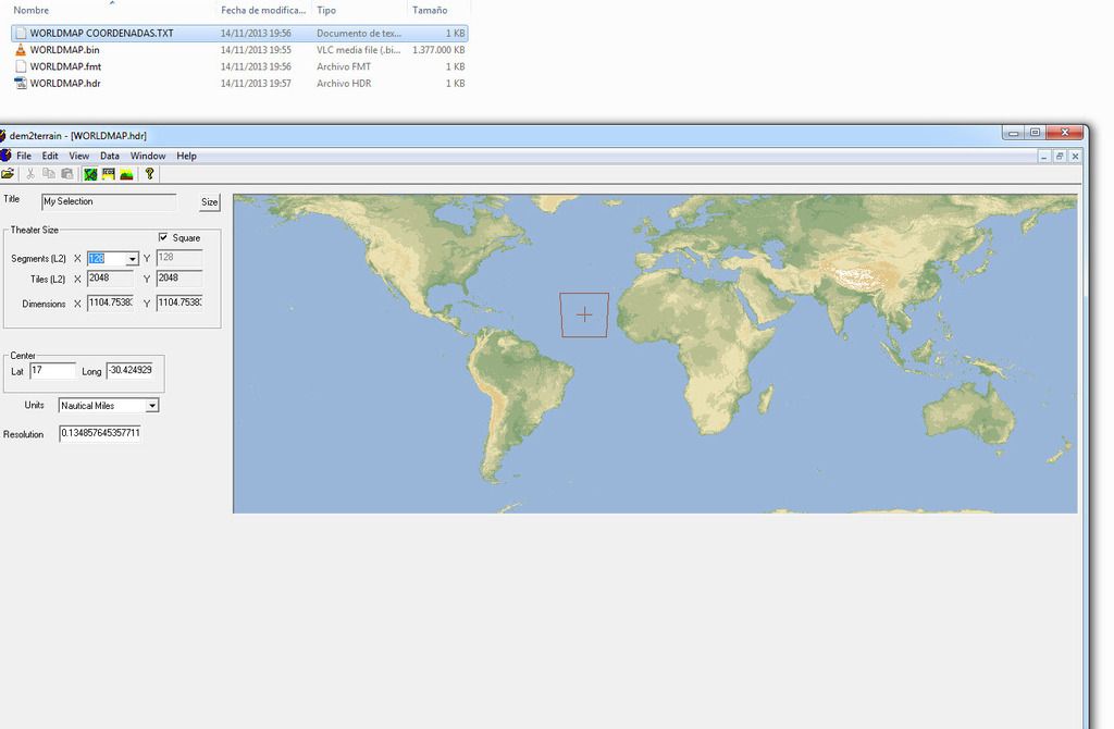
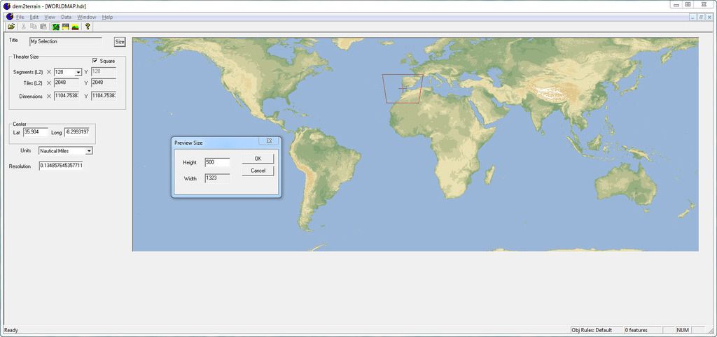
After opening the file, D2T says Height:151 Width:400
Cheers,
LS -
my cg.hdr is square…my settings is 400x400…i can set scale to 1000x1000 or 100x100 or 50x50 pixels without any problems…but with worldmap.hdr, no go…
not enough RAM???
-
not enough RAM???
With D2T and Worldmap opened my system uses around 1,8GB of RAM,
so I don’t think it’s a RAM problem.Cheers,
LS -
Intel i5 2500 CPU 3.3 GHz RAM8Gb The file will take to open in my PC 5 seconds.
I use dem2terrain.v1.9 Mirror MEGA.
THE util to convert DEM data to Falcon format. Extremely fast, extremely cool. by Julian Onions. Source
WORLDMAP.BIN is the result of merging files 39 downloaded separately.
WORLDMAP.hdr was edited manually to suit the new. BIN.
The bin and HDR files must have the same name; They should not be separated: very important.
The default preview size is 151x400 in the preview window. You can change the resolution to see it bigger. Change one of the values only; the other is automatically adapted (considering the resolution of your monitor)
-
-
I can’t get this to work either. No matter what I do, I can’t load the HDR file.


