Large Size Theaters
-
dolphins…I guess we are discussing different topics.
I think you are talking about tile texture resolution - it is 128, 256 or 512 pixels.
But we were talking theater resolution. Terrain consists of segments. One segment is 16x16 tiles patch. Default map is 64 seg in large - 64 * 16 tiles. Next possible size is 128 seg (it works). The biggest usefull is 256 seg, but it crashes BMS on start.
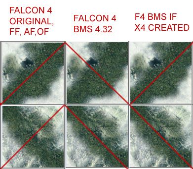
The problem with diagonals is about " how is the terrain patch tessalated". Individual tile-geometry is 4-vertex polygon (2 triangles) - so it has a diagonal edge. This edge was orientated SW-NE since the first Spectrum Holobyte simulation egine released (M1 tank i think). All Falcon 3 and 4.0 incarnations respected this except BMS 4.32.
I tried to explain the problem here for example:
https://www.benchmarksims.org/forum/showthread.php?9734-X1-color-in-BMS-4-32&p=216790&viewfull=1#post216790It has nothing to do with theater size, graphics card HW nor terrain datafiles (there is no value for it, its hardcoded imo) - unless new data introduced - see my hint:
If BMS guys want something special and top notch, this is the way to go IMO.
If not, I suggested this fix:
https://www.benchmarksims.org/forum/showthread.php?12389-One-BMS-Christmas-Wish&p=168874&viewfull=1#post168874 -
You mean there is a special function on vga cards drivers and if you enable that then the VGA can handle things better.
This is code side from BMS or a vga driver thing that you can force?
What about previous vga cards and drivers that don’t have support for 4k?
4k is 4096 x 2160 and most vga support a max of 2560x1200…yes i agree of that because if you arrange this solution, you must crack driver video to arrange sizing of tile with base10 in mathematic for translate information in new program
for example
stephane -
Hi Lucas,
For me, this subject of orientation of diagonals in terrain tiles is little arcane.Are you suggesting that BOTH orientations of the diagonals were to be used in the terrain at the same time? If so, there will be many cases that diagonals will be at different heights in the middle of the tile. How can polygon planes (and their normals) be calculated and rendered?
If the diagonals were to be determined by the content of the graphics (as in the example you show: valley along the diagonal) then would that be rather complicated procedure?
If diagonals were to have common point in the middle that would perhaps make most sense, it would be just as well, however, to use next higher tessalation of the terrain, which would be L1? That in turn would affect performance and perhaps cause terrain altitude “popups”, which was the main reason why in BMS L2 is exclusively used.
-
I moved debate into this thread :
https://www.benchmarksims.org/forum/showthread.php?9734-X1-color-in-BMS-4-32&p=335963&viewfull=1#post335963(this one is about large theatres)
-
This post is deleted! -
This post is deleted! -
I agree that decades is probably overestimating it, but it’s certainly a bigger project than a few weekends.
All sounds like a plan. Would you be REALLY interested to find out how the theaters are being created in Falcon, or are we done here?
-
There are ways to overcome the current limitations in 4.32 concerning large size theaters.BUT we lose some of the functionality we have become used to.
There has always been and will always be a Compromise that needs to be reached in Falcon, the Lost Pursuit guy’s did a reasonable job of accomplishing that in the last decade.
The BMS guy’s have taken it a step further in this decade and I am assured that the next BMS release, if there is a public one, will further address the Compromise.Cheers,
demer -
Any reliable software to convert DEM files into Falcon Theaters? We can download 1 arc sec DEM files (90 feet/30 meters resolution) but I don’t know how much resolution can handle.
Everyone is talking about 64 to 256 segments but nobody gives the point to metter/feet resolution for each segment. -
Dem2Terrain download here:
http://tactical.nekromantix.com/f4/downloads.php Browse forum and site for more information. Getting data to make Dem2Terrain for your use is the next step.Usually this is where this terrain making interest ends……:(
-
Any reliable software to convert DEM files into Falcon Theaters? We can download 1 arc sec DEM files (90 feet/30 meters resolution) but I don’t know how much resolution can handle.
Everyone is talking about 64 to 256 segments but nobody gives the point to metter/feet resolution for each segment.The resolution currently is 1KM x 1KM. To make use of anything lower (i.e 90m or 30m) you need a LOT of code changes, terrain specific code and also GFX code.
-
Watch the math:
demer
-
Is 4.33 able to compute additional 256 terrain files now, or does the FalconBMS crash as 4.32?
Are you going to update it? -
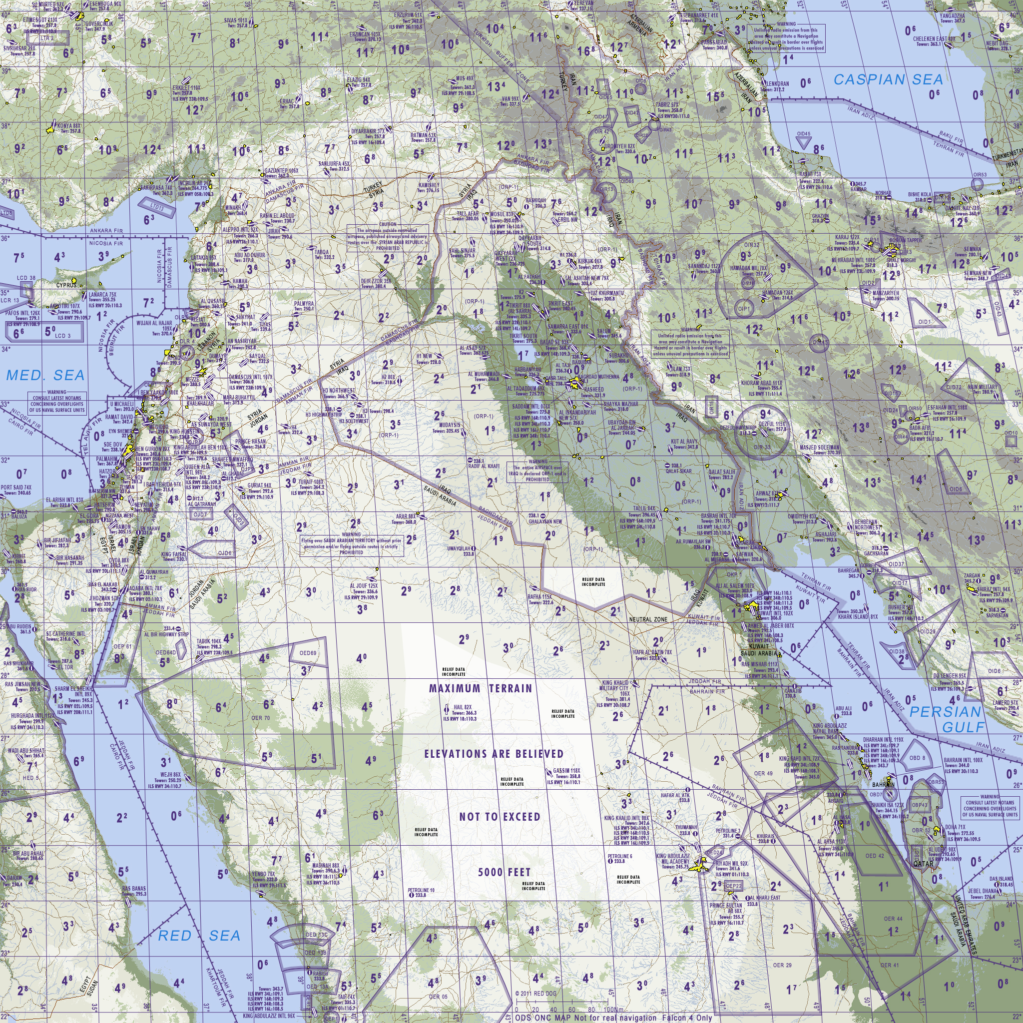
There are nice maps on this page:
http://users.skynet.be/bs999158/F4download_navigation.htm
There is also old 256seg Middle East map:
Were you able to make it work in BMS? I am asking because I have own different 256 seg theater, but BMS is unable to compute additional terrain files on start.
How did you make it work please? External program….? -
:bowd:
-
I have long downloaded the files of all the European countries available when I still had hopes of facing a theater of 256 sections.
Resubmit the global file link for dem2terrain.
I share these files on request
-
https://i.hizliresim.com/aL4Jb7.jpg
Nice timing Joe Labrada

Thanks for this files man It seams Russia files have problem.
and no Palestine data but we will try to find them. -
https://i.hizliresim.com/aL4Jb7.jpg
Nice timing Joe Labrada
Thanks for this files man It seams Russia files have problem.
and no Palestine data but we will try to find them.I know.
Readme into downloadble file:
http://data.geocomm.com/catalog/index.html

Admin/Political Boundaries - 1M - E00 Format
-Political/Ocean - Network
-Political/Ocean - Points
-Populated Places - Points
-Populated Places - Polygons

Hydrography - 1M - E00 Format
-Drainage - Network

Transportation - 1M - E00 Format
-Aeronautical - Points
-Roads - Lines

paises que faltan
rusia   http://data.geocomm.com/catalog/RS/datalist.html
no se carga en dem2terrain
I was unable to find complete available data for russia. These files that define the roads and rivers are missing (they were not available for download neither for free nor for payment). I downloaded all available files from all countries in Europe and North Africa, in anticipation that someday the web of http://data.geocomm.com fell (as has happened).
-
I think I have working Russia west data…
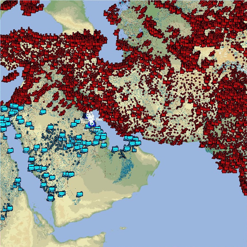
BTW there was 256 seg. working Middle east theater - I used to fly there in AF times (with corrupted normals).
The map I posted is classic 128 seg. Middle East, BMS can compute on start.I was asking howto compute 256…Monster, is it hard work to update your great TE to make BMS terrain files? (normals etc.)
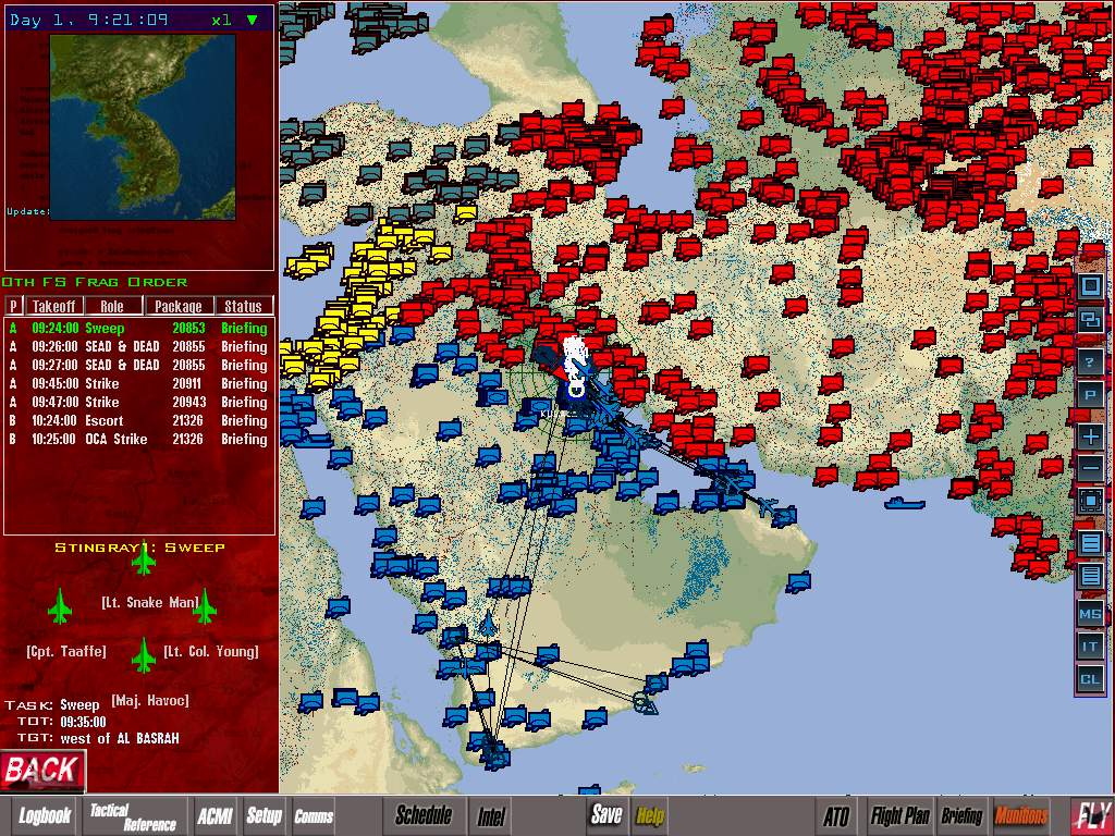
I know, its big, sux, i am stupid etc…but as was already said, MP is best with tactical engagements and huge maps are good for tac. eng.
I really love to fly MIG-31 and other interceptors, wanna make long bomb runs with refueling from Tule or send F111s fom England to Libya etc. etc… -
I ment this 256 PMC theater monster:
:mrgreen: