2 Questions: Divert Field and Mission damage assessment in campaign
-
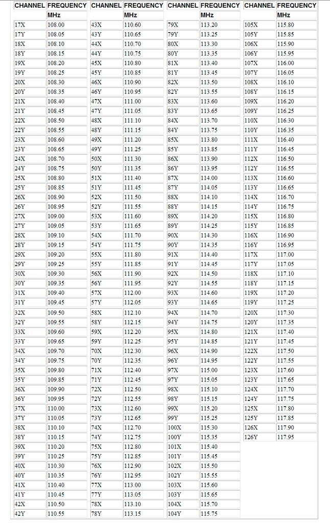
As for X or Y… someone correct me if I’m wrong, but Y is for air-air… and X for air-ground
-
Y is for air-air… and X for air-ground
Absolutely … unrelated.
") In fact no … It is just a matter of frequencies used.
In fact no … It is just a matter of frequencies used.Edit:
-
I had seen something that also indicated that in BMS X if for Ground and Y is for air, but wasn’t sure based upon the response from Chalis. So basically, ignore Chalis instructions for TACAN, follow heading to find field and don’t worry about tower frequencies there. Gotcha!
-
I had seen something that also indicated that in BMS X if for Ground and Y is for air!
If I remember corectly, it was in fact the case in very early versions of Falcon4 and was in the legacy original F4 manual. But no more (technically) the case now. And is not the case IRL either.
ASUSTeK ROG MAXIMUS X HERO / Intel Core i5-8600K (4.6 GHz) / NVIDIA GeForce RTX 3080 Ti FE 12GB / 32GB DDR4 Ballistix Elite 3200 MHz / Samsung SSD 970 EVO Plus 2TB / Be Quiet! Straight Power 11 1000W Platinum / Windows 10 Home 64-bit / HOTAS Cougar FSSB R1 (Warthog grip) / SIMPED / MFD Cougar / ViperGear ICP / SimShaker JetPad / Track IR 5 / Curved LED 27'' Monitor 1080p Samsung C27F396 / HP Reverb G2 VR Headset.
-
I noticed that any time I request vector to nearest landing field in HSD there appears a steerpoint placed where a nearest divert field is (for me it is usually Mandumi, TACAN 01Y (?) but I think it can be any nearest field). I think it is a new feture in 4.33. Can you explain how exactly it works?
I figured out this new steerpoint is created by moving the original homeplate steerpoint on HSD to a divert field location and drawing a line from the original place.however
on DED stp page [4] coordinates for this new steerpoint remain the same as for original steerpoint it were derived from. I took of from Osan (stpt 1 and 10), then while going home asked for nearest field, got new steerpoint modified from stpt 10, but coordinates in DED stpt page for this modiffied steerpoint were the same as of Osan.
To me it’s a bug. By not knowing exact coordinates I cannot compare with AIP to know which field it is and what is TWR frequency.Did someone notice that too?
-
I haven’t had to divert very often, but just the other day on the Israel theater I came out of a dogfight on fumes and asked for a divert. AWACS directed me to a Jordanian airfield, and the TACAN he gave me was correct, could it just be a KTO problem?
-
request vector to nearest landing field in HSD there appears a steerpoint placed where a nearest divert field is
I think this is placebo effect. Normal flight plan will put a waypoint on alternate after primary. Asking for vector to emergency recover does nothing to change your HSD picture. It is a coincidence that the field AWACS says and your flight plan has were the same that day.
-
I think this is placebo effect. Normal flight plan will put a waypoint on alternate after primary. Asking for vector to emergency recover does nothing to change your HSD picture. It is a coincidence that the field AWACS says and your flight plan has were the same that day.
Actually I too have seen this: request vector to alternate and immediately the waypoint (for the alternate - not the closest though) is chosen on the HSD and on HUD, while interestingly enough the waypoint mark for the home base is gone on the HSD (although the path to the home base is still on the HSD)>
-
Sounds buggy as a Motel 6.
-
If AWACS gives you the name of the divert Airbase why dont you use the tables form the Docs folder that has coordinates of each airbase and insert the coordinates as STP and fly to that point . thats what i usually do without asking AWACS, I look at my location in the HSD and i insert the coordinates of any close airbas and switch to their tower frequency and ask them for landing.
-
I had seen something that also indicated that in BMS X if for Ground and Y is for air, but wasn’t sure based upon the response from Chalis.
If I remember corectly, it was in fact the case in very early versions of Falcon4 and was in the legacy original F4 manual. But no more (technically) the case now. And is not the case IRL either.
Well friend “Dee-Jay” you are partially correct.
In real life of course we can have signal from a ground TACAN station that has a band of Y.
In Falcon 4.0 Allied Force, in BMS 4.32 as also in BMS 4.33 we can’t have a signal from a ground TACAN station that has a band of Y.
Check it, it’s easy…
Nikos. -
If AWACS gives you the name of the divert Airbase why dont you use the tables form the Docs folder that has coordinates of each airbase and insert the coordinates as STP and fly to that point . thats what i usually do without asking AWACS, I look at my location in the HSD and i insert the coordinates of any close airbas and switch to their tower frequency and ask them for landing.
Does AWACS really give you the name of the divert field? I’ve never heard it before. AWACS communicates are like this: “[flight, number], divert field available, bullseye xx, yy miles” When asked again, AWACS also adds TACAN chanel. That’s all, I never heard AWACS gives the name of the airbase. If he does so, it would not be a problem at all.
-
Does AWACS really give you the name of the divert field? I’ve never heard it before. AWACS communicates are like this: “[flight, number], divert field available, bullseye xx, yy miles” When asked again, AWACS also adds TACAN chanel. That’s all, I never heard AWACS gives the name of the airbase. If he does so, it would not be a problem at all.
That’s why I was basically asking IF AWACS gives the name of the divert Airfield then he can do that approach. But what I rather do never involve asking the AWACS for a divert Airfield . Before every mission I draw a sketch of my flight plan with the steerpoints numbers on an A4 paper and I draw the location and names of friendly airbases close to each steerpoint . for example if STP # 4 has an airfield close I just put a mark on the A4 paper close to that STP . Then when I fly and lest say im out of fuel and I need to divert to a friendly airfield I look at my HSD and see what STP is close to me and if im close to STP #4 then I know that the closest AIRBASE is ( any name ) .
What I do next is I switch to the tower frequency and I put the ILS info in DED menu 1 and I put the coordinates of the AIRBASE in any open STP like 51 or 52 and I fly there .
I don’t know if this approach can be done in real life I have no idea but I implemented it since I don’t have in game map like in DCS so I had to depend on my own sketch. -
An interactive moving map is an option if you have an Android tablet laying around not being used. You will see where you are on the moving map and all the bases nearby (with all the base info).
