WIP - Guam Theatre
-
maybe it’s a bit OT.
but is there a better method than stamp and paste from google/bing maps to obtain large images? since is really time consuming making all the shots then import in PS and link them up propely. anyway for my machine a 4096sq image in dds with alpha is quite hard to handle…
the quality of satellite images is the key imho for the analisys of high res/low res. a good image will look better @1024 low level only if the source has that kind of resolution and is not resizing the smaller one
-
is there a better method than stamp and paste from google/bing maps to obtain large images? since is really time consuming making all the shots then import in PS and link them up propely. anyway for my machine a 4096sq image in dds with alpha is quite hard to handle.
For processing large photorealistic pictures it is top important to have a lot of memory and HD space …and reasonable late Photoshop for proper DDS format manipulation.
Do not torture yourself with manual d/l and pasting. Try SBuilderX. However, problem there :waterstamp.
http://www.ptsim.com/index.php?option=com_content&view=article&id=52&Itemid=56 -
Dave,
I made some further investigation into this project and I wonder if mentioned by you MapTiler for Google (which you have used to slice the image to tiles) is making all those rather poor 256 textures. Check the original image which was used to make the tiles (if you still have one).You know that Photoshop can also slice any image to any size tiles. It will save in png which in turn can be converted to Dxt5 dds with DDs converter. Advantage of this path is that you can easy edit transparency for water on the large image before slicing and all those above mentioned processes will keep the transparency channel. Selecting water areas on big image is much easier and faster than on thousand tiles later after slicing.
So first you convert all to DXT5 and then you can just pick land tiles and batch convert them again to DXt1.
Hi Ted,
Thank’s again for your effort’s on this little Theater.
I still have the original map mash up’s and can 7zip them to you if you’d like.
Let me know.
They contain the jpeg main and split’s as well as the original dds tile’s.
Though I think your HiRez texture’s look much better and would like to pursue that more if your up to it.As stated,I don’t care about texture Folder size anymore when it come’s to the installer.BUT I agree that 512x512 is prob’ly a good compromise for Falcon.As you can see from the texture .bin file I did not use any water SET’s. I played with it a couple month’s ago,as did Brian,and found the DX engine is basically caring about the Alpha channel to render the water shader’s.DXT3 worked fine for me.
Also, as I am starting to build the Red Flag Campain’ the GU\NU\AU are performing quite nicely without defined AREA’s on the tile’s……very interesting to me?!?!?!!?Dave
-
I still have the original map mash up’s and can 7zip them to you if you’d like. Let me know.
Send me , I 'll take a look not perhaps in order to redo the textures but to find out why 256 textures appear to be so lossy (it is perhaps because the main is JPEG format).
and found the DX engine is basically caring about the Alpha channel to render the water shader’s.DXT3 worked fine for me.
DXT3 is fine as long one does not want that feathered effect on the shoreline when transparent meets solid. Only DXT5 allows to have this alpha gradient (gradual transition of transparency).
-
Dave, sorry for forgetting screens as thank you, I took quite some nice shots, but accidently deleted the upload, now too tired.
Also wanted to post shots at FF -other stuff of course- but barely can type now almost 06.00 tomorrow action butt day.
Lol, Arapron tired type mode, ignore and carry on.Cheers men…
Tom
-
Send me , I 'll take a look not perhaps in order to redo the textures but to find out why 256 textures appear to be so lossy (it is perhaps because the main is JPEG format).
DXT3 is fine as long one does not want that feathered effect on the shoreline when transparent meets solid. Only DXT5 allows to have this alpha gradient (gradual transition of transparency).
Sorry to pork this a bit but reading this stuff wouldn’t be a tilers heaven and hell as workload that this transparency thing could work and on ground tiles so that their transition could be better? like from mud to rocks and sand? like made up tiles to photoreal?
As I understood it this can be done only with water tiles right? Wouldn’t be nice to have the ability for custom declare the transparency of tiles? Or is it done already?
Sorry for the OT.HOT LIST

System Specs:
i7-2600K @ 4.8 Ghz WaterCooled / 32GB Ram. 128GB SSD/1TB SSD / GTX1080Ti 11GB DDR5X / HOTAS COUGAR. TrackIR 4 / 3x24" Mon. (res:5760x1200) / Cougar MFD's / Wheel Pedals / Win 10 64 bit.

-
Wouldn’t be nice to have the ability for custom declare the transparency of tiles? Or is it done already?
It would require that @ transition 2 textures be allowed to occupy 1 space. It is not in Falcon4, but this in fact is how most transitions are being handled in engines which allowed for that and is called texture splatting.
Other than that DXT5 is 342 KB and nontransparent DXT1 is exactly half of that. So, no saving by not having transition prerendered.
-
It would require that @ transition 2 textures be allowed to occupy 1 space. It is not in Falcon4, but this in fact is how most transitions are being handled in engines which allowed for that and is called texture splatting.
Other than that DXT5 is 342 KB and nontransparent DXT1 is exactly half of that. So, no saving by not having transition prerendered.
lol Size doesn’t matter… lol Really with this new gfx and terrain engine it seems that there will be no problem as the “OLD” days.
The thing is that this transparency is set to sea tiles only?
Well to tell us the truth nope.
Cause as the guides say u put alpha not to sea tiles but coastline tiles and the same for rivers and lakes…
So let’s say if we declare all tiles as sea tiles than we will have the transparency? Right?
Does it affect anything else except the massive suicide attempts, strokes and heart attacks by tile and theater creators??? LOLHOT LIST
System Specs:
i7-2600K @ 4.8 Ghz WaterCooled / 32GB Ram. 128GB SSD/1TB SSD / GTX1080Ti 11GB DDR5X / HOTAS COUGAR. TrackIR 4 / 3x24" Mon. (res:5760x1200) / Cougar MFD's / Wheel Pedals / Win 10 64 bit.
-
except the massive suicide attempts, strokes and heart attacks by tile and theater creators
I hope not!
Transparency is not limited to water tiles. You can put alpha channel in any tile you want.
The question is to what purpose? ATM for water and also I have used that same trick for mountains and snow.
Anything else? Transitions? Possible. Currently, however, that would not work, unless coders introduce some new ways the textures are handled and used. -
This is incredible. Can’t wait to fly in it.
-
Redflag campaign is heating up……
")
Heading south to take care of a few Blue guy’s:
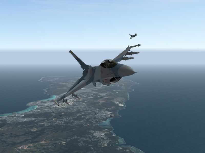
Buzzing past NAS Guam:
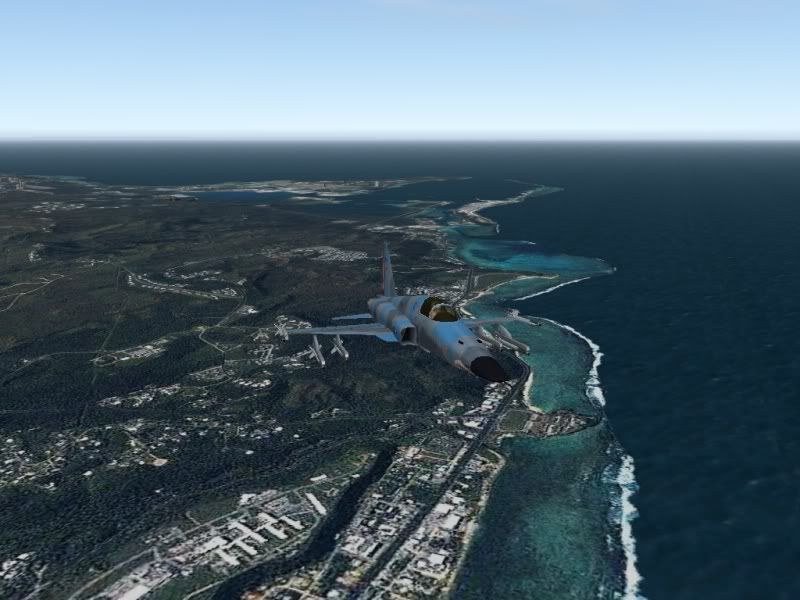
Getting ready for some Cat and Mouse play:

demer
-


Cheers,

LS -

Not bad my friend. Needs more resolution below 7000, but quite immersive! Now add those alphas for seatiles and up it goes.
Main base still levelling issues, took a screen, but I assume that’s not new to you, also only took a short flight last night.:lol: -
Not bad my friend. Needs more resolution below 7000, but quite immersive! Now add those alphas for seatiles and up it goes.
Main base still levelling issues, took a screen, but I assume that’s not new to you, also only took a short flight last night.:lol:Thank’s for taking it for a spin there Bugbutt,
Yeah,Ted and I are looking at the resolution and manipulating the Alpha’s ATM….we’ll “see” what come’s of it…LOL
AB leveling is known,they are just placeholder’s in A2 build.
Short flight’s is the Norm for this theater.If you fly more than 40 minute’s in any direction,then you fly right off the MAP!!!..LOL (maybe I can put in a “Return to Battle” message like in COD\MW or your K’dIA???)
You have about 10-15 minute’s Flight Time in Campain’ B4 you are either engaged or reach your target.Sometime’s less ala “SCRAMBLE,Enemy inbound’s”…hehehe
I think it will provide some intense action for the player,once I slap the “ScriptMonkeys” around a bit more…;)Dave
-
I was based on Guam nearly 10 years. I even occasionally saw F-16s on the upper J’s making the trip south from Japan with tanks. Very nice!
BTW, I find the 2D map shot showing the bad guys holding Tinian and Saipan somehow disturbing
")
Another BTW: the hills to the south are quite off.
-
Good points Smoking hole. Thanks. I am currently working on some improvements to Guam and those hills are on my agenda. I have learned from ITO2 to visit Google Earth and Panoramio photos of the area in works to get the better feel of how the terrain looks. It is part of the fun too.
-
Keep up the great work guys. Can’t wait to fly this baby.:twisted:
Hammer97
-
A little RedFlag campain’ action,everything was going smooth til’ those pesky F18’s showed up….LOL:
http://s632.photobucket.com/albums/uu49/demer928/?action=view¤t=Movie-3.mp4
Stay tuned,
demer -
Progress shots on Guam project:
Corrected tiles (still in progress) and amended topography plus same view from Google Earth


Overal view from air and the same in real.


-
Given the importance Guam is taking IRL to US defense in the Pacific, this theater is an outstanding idea and well worth the effort being put forth. Certainly, it will be a challenge to all. Couple of suggestions. If the intent is to include a Red Flag scenario for training as part of the theater, then it should be named Cope North vice RF. RF is a Nellis and Alaska (RF-Alaska) exercise. While the USN Aggressor F-5s certainly are a worthy adversary, most likely Cope North would (and does) feature the 18th Aggressor Sq from Eielson AFB as the host adversary unit. Certainly other unit augment them from time to time so the JASDF F-15DJ of the Hiko Kyodotai (Tactical Fighter Training Squadron) would be outstanding in this scenario. Thanks for the great work in progress.