Aegean Theatre - IAP charts
-
Oh My My!!!
-
Bravo Nikos, Bravo. Your chart is an absolute masterpiece and stroke of genius. I would love to have your airways integrated/superimposed into the BMS Aegean UI map. In that way, we could set out waypoints using real world navigation points.
Hi there my good friend Gavin.
Thank you for your kindly words.
Well, wait to finish also and the other charts and then we can coordinate that.
Until then, just enjoy this innovating chart .
.
Nikos. -
Professional genius!
Thank you Nikos for your steady effort on realism for BMS. Most valueable.
I hope you take the time to sit back and have a beer sometimes, too!livrot
-
You never cease to amaze me, Nikos.


Cheers,

LS -
Thanks all of you Gentlemen.
It is very nice to see you so pleased. That encourage me to go ahead ;).
See you then at the Enroute chart for North Greece.
Nikos. -


"I did find myself […] looking into the face of those SA-8s and the two Rolands. My impression of why I survived is that here I am, with the radar cross-section the size of Mount Rushmore, and here are these Iraqi SAM missile operators going, 'Cease fire, Cease fire, don´t shoot! Here´s two dumb Mike Foxes at 20,000 feet and 200 knots-you know, must be Iraqi, hold fire, hold fire!' I think that´s the only thing that saved us"
-
Hi guys.
Well the Enroute Low Altitude chart for North Greece created.
Below you can see a preview of the chart (must print it at A3 paper size - 42x29.7 cm or 16.54x11.69 inches):
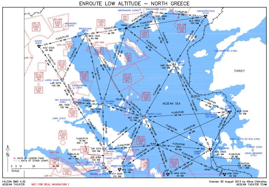
You can download it from the first post of this thread!
Next will follow for the North Turkey and the South Turkey in order to cover all the Aegean theater!
I hope to really enjoy it.
With my best regards,
Nikos Efstratiou. -
 oooo:o
Amazing work!!!
-
:bowd::bowd::bowd::bowd::bowd::bowd:
Thank you mate.
-
Your work is just brilliant…
")
-
Incredible work as usual brother!!
-
The god of navigation charts. Respect on that creation…
Greetings
System Specs: WIN11 Enterprise. Asus Z690-A Prime (DDR5) Intel Core™ i7-12700KF Processor. Corsair H100x 240mm Water cooling. ADATA XPG 16GB DDR5-5200 Lancer RAM, Asus GeForce® RTX 3080 12GB TUF. Kingston NV1 2TB M.2 NVMe SSD HD + WD Blue - 4TB HD. 32" Asus VG32VQ1BR TUF - QHD - 1ms - HDR - 165Hz Gaming Curved main screen - 24" screen for YAME and TM MFD. LogiLink 7+1 USB 3.0 hub, TIR4, Cougar HOTAS FSSB, Saitek Combat Rudder, Viper wing ICP.
-
Time to change memes
"I did find myself […] looking into the face of those SA-8s and the two Rolands. My impression of why I survived is that here I am, with the radar cross-section the size of Mount Rushmore, and here are these Iraqi SAM missile operators going, 'Cease fire, Cease fire, don´t shoot! Here´s two dumb Mike Foxes at 20,000 feet and 200 knots-you know, must be Iraqi, hold fire, hold fire!' I think that´s the only thing that saved us"
-
Thanks Nikos. Excellent work!
-
And another top notch chart by Nikos, … delightful

Cheers,
LS -
And another top notch chart by Nikos, … delightful
Cheers,
LSHaha, THANK YOU very much my good friend LS as also for your very nice and sexy gift…!

Also i want to thank ALL of you guys for your very kindly words and your support to me and to Aegean Theater Team!
See you at the next project…
Nikos. -
Great work Nikos. If I want to print your charts onto paper, what is the best size? Would 8 1/4" x 11 1/2" be too small to read the stations?
-
Brilliant… & great job friend… you’re the man :bowd::bowd::bowd::headb:
-
Great work Nikos. If I want to print your charts onto paper, what is the best size? Would 8 1/4" x 11 1/2" be too small to read the stations?
A3 I think…or that he said
-
Great work Nikos. If I want to print your charts onto paper, what is the best size? Would 8 1/4" x 11 1/2" be too small to read the stations?
Thank you my friend Gavin.
Well for best result, print the 2 Enroute charts at A3 paper size (42x29.7 cm or 16.54x11.69 inches).
At A4 paper size (29.7x21 cm or 11.69x8.27 inches) i think that the data will be not good enough readable. If you want, give it a try.
Only the legend page must be printed at A4 paper size.
I hope to enjoy them.
Nikos.

