Question on ILS landing with instruments
-
I am trying to do an ILS landing as described in this vid tutorial
I have all my frequency and course headings for the runway.
I have switched the knob on the HSI from Nav mode to ILS/Nav mode.
My hud shows ILS with the static cross hairs
On the ICP, I hit “1” for the ILS. However, I don’t get the scratch pad as shown in the vid at about 13:30 mark.
My display on the ICP shows long and lat numbers, planned altitude and waypoint number. There is no area to enter frequency and course
I looked at other tutorials for BMS and they all show the scratch pad when hitting “1”How do you get the ILS scratch pad up, is there some other setting I need?
-
sounds a lot like what happens when you press the 4-STPT key rather than the 1-T-ILS key… sure you pressed the right one?
-
Do not forget ILS “ON” on the left console (Volume).
-
sounds a lot like what happens when you press the 4-STPT key rather than the 1-T-ILS key… sure you pressed the right one?
Yes, agree, he’s on the wrong DED page (maybe pushing ‘LIST’, then ‘1’).
Start from the ‘main’ DED page; get there by pressing ‘RTN’ on the switch below the ICP. Should be this page:

Now go to the ILS page by pushing ‘1’ on the ICP.
Also, here another very nice ILS/TACAN tutorial video:
-
Better than the docs that’s for sure.
Love the music in that tut more than the tut lol.
The guy above must have Frank Zappa’s and Einstein’s genes to understand that hsi guage so well. -
@smasha:
Better than the docs that’s for sure.
Only for basic stuff, but less complet than RedDog’s chart tutorial located into Docs folder.
Video tuto must be a complement to .pdf manuals, not a substitute. If you do only watch video tuto, you will miss hundereds of details.
So yes, vdeo tutorials are very valuable, but no, they are not sufficent.
-
Only for basic stuff, but less complet than RedDog’s chart tutorial located into Docs folder.
Video tuto must be a complement to .pdf manuals, not a substitute. If you do only watch video tuto, you will miss hundereds of details.
So yes, vdeo tutorials are very valuable, but no, they are not sufficent.
The hard part is how he plots that imaginary course to end up straight down the runway.
I suppose you have to do that to leave enough room to prepare for the final landing but getting to that point???That part is fudgy in my mind but I need to get it stuck in my head what he is doing in the first place.
The HSI doesn’t make things easy when there are so many pointers that look the same.You would think they would have everything coloured differently instead of being white.
-
Actually its a huge improvement over the older type of gauges that older aircraft used for radio navigation. HSI all the way!
-
It used to be two separate instruments, heading indicator and navigation head gauge. This was truly annoying to have to look two places for your approach info.
http://www.sgsim.com/instruments/DSCN7513-gyro-300.jpg
http://www.sgsim.com/instruments/DSCN5829-NAV1-316.jpg
The downside to the combined HSI is it is very busy like you said. The HUD ILS crosshairs with the command cue are so simple. The command cue “put FPM on this” is so easy it’s no fun anymore.
The ILS final approach signal is great to get from the final approach fix to the decision height which is the last, straight part of the instrument approach. Of course you approach the airport from any direction at any altitude. This is why there is a published approach procedure which delivers you from initial approach fix (IAF) to final approach fix (FAF). As approach is being followed you are placed in a good intercept position for ILS signal automatically. In reality no one flies by themselves toward an ILS signal. Either you fly the full approach or ATC gives you vectors to some part of the approach between IAF and FAF.
http://www.candyparty.com/ST/Download/Checklists/Allcharts/Allied/107_fukuoka_ils_01.jpg -
Ive been amusing myself recently by flying simulated HUD out IFR approaches, found that I had a bit to learn still! Got a lot of helpful stuff out of an AFMAN11-217 volumes 1 and 3… and 2 was good reading but not so useful for this case. Certainly is a lot more work than just following the command cue, had one flight from Osan to Kangnung just recently IFR following the tacan beacons to get there. Ended up taking me 3 approaches to land finally, but it was certainly good practice. Tis a bit frustrating going around for a second time back to a missed approach…
Not ever having used the older instruments the HSI doesnt really seem busy to me, it only shows a few useful pieces of information really, direction the beacon is, distance to the beacon, and your alignment with a radial. 3 pieces of information isnt too bad for one gauge, could be worse.
-
If you can and maybe get Microsoft Flight Sim do both Visual and IFR practice and pull some info on the web regarding VHF and UHF. VOR’s and more. A lot of learning it will be. Fly a single engine first than move on to this. You will come to realize if you have not already there is more to flying than bombing. Most pilots (hobbyist, commercial and military) have something in common they learned from just taking lessons and from Microsoft Flight Sim prior to being where they are now. Yes MFS is used for some training by real pilots out there, regardless of its graphics and some other things. You already have a stick and a cpu that can handle this sim. Try another flight sim like the one mentioned above and you will see. Boy there is much to learn. Currently what is involved in BMS is not as detailed as some other sims when it comes to navigation, communications with multiple flights, and more. Give it a look. You probably have already. BMS is a tactical sim more so than a navigational sim.
-
Had about 200 hours in FSX before Id even heard of Falcon…. never flew IFR in it though. Bought it originally before I got my RA-Aus pilots license, as I couldnt afford flying hours at the time.
FSX without mods is mostly of use as a procedural trainer, but its very capable in the field of training IFR. The Bunbury Flying School still use it to run their Simulated Instrument Trainer.
-
What’s “fun” is putting your head between your legs and flying an entire instrument procedure in BMS from IAF to MAP looking at only the round airspeed gauge, altimeter, ADI, and HSI. When your altimeter reads airport + 200’ heads up and land it. It’s actually good practice and not too hard.
-
What’s “fun” is putting your head between your legs and flying an entire instrument procedure in BMS from IAF to MAP looking at only the round airspeed gauge, altimeter, ADI, and HSI. When your altimeter reads airport + 200’ heads up and land it. It’s actually good practice and not too hard.
Thats how I flew the Osan to Kangnung ferry flight I mentioned, was definitely interesting. Although you need to be heads up before minima… was interesting to do as instrument flight is not something Ive done any of outside of simulation.
-
BMS is a tactical sim more so than a navigational sim.
Principle of instrument flight remain exactly the same, and a military pilot can use BMS the same way than FSX (or older) for radionavigation.
ASUSTeK ROG MAXIMUS X HERO / Intel Core i5-8600K (4.6 GHz) / NVIDIA GeForce RTX 3080 Ti FE 12GB / 32GB DDR4 Ballistix Elite 3200 MHz / Samsung SSD 970 EVO Plus 2TB / Be Quiet! Straight Power 11 1000W Platinum / Windows 10 Home 64-bit / HOTAS Cougar FSSB R1 (Warthog grip) / SIMPED / MFD Cougar / ViperGear ICP / SimShaker JetPad / Track IR 5 / Curved LED 27'' Monitor 1080p Samsung C27F396 / HP Reverb G2 VR Headset.
-
Principle of instrument flight remain exactly the same, and a military pilot can use BMS the same way than FSX (or older) for radionavigation.
Normally wouldnt there be TACAN beacons not co-located with airbases?
-
Normally wouldnt there be TACAN beacons not co-located with airbases?
Even so, the principles remain the same. Also worth noting that many TACAN stations on the BMS map overlap (i.e., just as you’re losing the Taegu station, you’re picking up the Kunsan station), allowing ‘station-to-station’ navigation to some terminal point. And, where/if needed, navigation fixes can be added/supplemented to a BMS ‘radio nav’ flight plan …. the Korea/Japan ADIZ, for example.
While it may be correct to say that BMS doesn’t offer the number or level of radio navigation points available in the real-world, one can still apply real-world radio navigation principles within the limitations of the BMS map.
-
you can apply the principles, sure, no arguments there - see recent flight using said principles.
I dont think anyone is actually arguing that point though. What I did want to query though, was whether flying from point to point, with none of the points involved having a radio beacon, was common IRL. The flight I did a few days ago ended up using Osan, Choongwon and Kangnungs tacan stations, and flying set headings to the specific points verified using the tacan. None of the individual legs were amazingly precise though, as after departing DRAGGIN and until KANGWON, none of the legs were along radials from any station. It just ended up being that after passing the radial of the turn point, Id start a turn to the preplanned heading and then set the HSI for the radial and channel of the next turn point. Is that something you are just expected to accept IRL?
Wikipedia reckons that navigating the way I did is closer to something called Area Navigation rather than normal use of tacan.
-
…. None of the individual legs were amazingly precise though, as after departing DRAGGIN and until KANGWON, none of the legs were along radials from any station. …
In a very technical sense, there were in fact on a radial from some station or another.
In a practical sense, they could have been if you had chose to plan your flight that way. Something like:
OSAN Draggin One Departure,
Then R-285 on 005x to station,
Then R-060 to DME33,
Then R-225 on 056x to station,
Then R-040 and enter pattern at 12 DME (IAF).Simple ‘station-to-station’ is easier on the planning (and flying) though.
Real world? ….
 … I fly coach.
 -
None of the individual legs were amazingly precise though, as after departing DRAGGIN and until KANGWON, none of the legs were along radials from any station. It just ended up being that after passing the radial of the turn point, Id start a turn to the preplanned heading and then set the HSI for the radial and channel of the next turn point.
Hi there “Blu3wolf”.
Well you mean that your flight “legs” were not precisely on a Radial from a TACAN station while you were flying to the next one?
If this is the matter, take a look at this Enroute Low Altitude chart for Southern Aegean Sea of Aegean theater and give it a try:
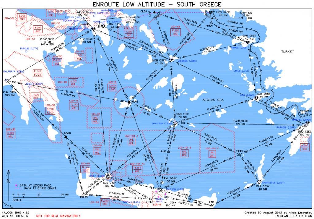
You will be amazed about the precision of the charts ;).
You can have all the navigation stuff via the Hotfix at the end of the post #1 here: https://www.benchmarksims.org/forum/showthread.php?8426-Aegean-Theatre-IAP-charts
Nikos.

