Balkans 4.33.1 HOTFIX 2 for Falcon BMS 4.33 Update 1….Obsolete thread. Link removed
-
Link Removed for new Balkans Update 4.33.1c
Go to the main Balkans thread here and download
-
good job
-
Nice to see Balkans updated, cougar.


Cheers,

LS -
Thanks a lot for your attention from me too, Cougar.
With best regards,
-
I noticed there seems to be no airport diagram for Brindisi-Caesale. I’ve created my own based on NK Wonsan, let me know if you’re interested and I’ll share it here or for inclusion in the next update.
Cheers, Uwe
System specs: win10pro / Linux Mint 21.x, 32GB RAM, RTX3070, 2x1 TB SSD, 1x2TB NVMe, 1x4TB SATA; HOTAS Warthog Stick(DX), WinWing Orion2 Throttle w/ f16 grip, TM MFDs, CH Pro Flight Pedals w/ custom USB controller; CPU: AMD Ryzen 7 3700X 8-Core; MoBo: X570-A PRO (MS-7C37); Display: 42" LG Nano 42 (2560x1440), 19" Fujitsu-Siemens (1280x1024) used for DE /w YAME64 beta; DelanClip /w PS Eye, opentrack; GameTrix JetSeat /w SimShaker Wings; Stream Deck XL (32 buttons) as ICP
-
Thank you Cougar!!! Will have a nice time there!
-
I noticed there seems to be no airport diagram for Brindisi-Caesale. I’ve created my own based on NK Wonsan, let me know if you’re interested and I’ll share it here or for inclusion in the next update.
Cheers, Uwe
Hey Hoover,
There will be another update since I did some more things with Aviano and Nikos is making some approach charts. I also added the HUD mod to the jets that don’t have the block 40 HUD. As soon as Nikos gets the approach charts for Aviano done then I will release another update and add an updated Brindisi airport diagram. There are airport diagrams in the Docs folder for Brindisi currently though.
Intel Core i9-12900KF 3.2 GHz Processor; ASUS Strix Z690-F Motherboard; G.Skill Trident RGB 32GB (2x16) DDR5 5600 MHz Memory; EVGA GeForce 3090 RTX 24 GB Video Card; LG 34 inch 21:9 Curved UltraWide QHD IPS Monitor; 2 8 inch CubeSim MFD Monitors, SimGear ICP, FSSB R3L Ultra MkII Stick Base with Thrustmaster F-16 Grip, Thrustmaster Viper TQS Mission Pack Throttle Setup, Thrustmaster MFD Buttons, Track IR 5, HP Reverb G2 VR Headset; Windows 11 Pro 64 Bit
-
Thanks cougar, I would never have found those in the “quick access guide” which has 500+ pages. Maybe it would be a good idea to put the airport diagrams into the MAIP / navaids document?
thanks & looking forward to the next update, and to Nikos’ excellent charts of course!
Uwe
System specs: win10pro / Linux Mint 21.x, 32GB RAM, RTX3070, 2x1 TB SSD, 1x2TB NVMe, 1x4TB SATA; HOTAS Warthog Stick(DX), WinWing Orion2 Throttle w/ f16 grip, TM MFDs, CH Pro Flight Pedals w/ custom USB controller; CPU: AMD Ryzen 7 3700X 8-Core; MoBo: X570-A PRO (MS-7C37); Display: 42" LG Nano 42 (2560x1440), 19" Fujitsu-Siemens (1280x1024) used for DE /w YAME64 beta; DelanClip /w PS Eye, opentrack; GameTrix JetSeat /w SimShaker Wings; Stream Deck XL (32 buttons) as ICP
-
I just checked the access guide and indeed the Brindisi Casale airport diagram is in here.
However I’m seeing three different data points for the runway elevation:
- MAIP / Overview / Area Chart claims 48’
- Approach charts and aiport diagram claim 95’
- “recon” view of the airport says 5’ msl
- Wikipedia page lists 47’
So which one is it?
")
Cheers, Uwe
System specs: win10pro / Linux Mint 21.x, 32GB RAM, RTX3070, 2x1 TB SSD, 1x2TB NVMe, 1x4TB SATA; HOTAS Warthog Stick(DX), WinWing Orion2 Throttle w/ f16 grip, TM MFDs, CH Pro Flight Pedals w/ custom USB controller; CPU: AMD Ryzen 7 3700X 8-Core; MoBo: X570-A PRO (MS-7C37); Display: 42" LG Nano 42 (2560x1440), 19" Fujitsu-Siemens (1280x1024) used for DE /w YAME64 beta; DelanClip /w PS Eye, opentrack; GameTrix JetSeat /w SimShaker Wings; Stream Deck XL (32 buttons) as ICP
-
I just checked the access guide and indeed the Brindisi Casale airport diagram is in here.
However I’m seeing three different data points for the runway elevation:
- MAIP / Overview / Area Chart claims 48’
- Approach charts and aiport diagram claim 95’
- “recon” view of the airport says 5’ msl
- Wikipedia page lists 47’
So which one is it?
Cheers, Uwe
My dear friend Uwe,
Take 5 minutes and think about your question…- Can you ever base your approach in BMS simulator to what Wikipedia said? Probably NO.
- Did you read real approach charts? Because they give 29 FT for RWY 13 and 26 FT for RWY 31 of Casale airport (LIBR), and NOT 95 FT.
- Where can you read in the MAIP chart RWY TDZE of 48 FT? Because I give TDZE 0 FT.
- Final and most important, in the altimeter of your jet when you are over Casale RWY and with the default weather, you can read 0 FT. So this is the RWY elevation that you can trust and use ;).
Nikos.
-
btw, static port height is implemented
so if airport elev is 10 feet, altitude will be 16 while on the ground. Because the probes are around 6-7 feet from the ground")
That explains the difference between AC and external view by 6-7 feet (when altimeter is set correctly again) -
Thanks guys, with the altimeter set to local pressure it indeed reads about 10 feet altitude on my end.
@Nikos: If you check the MAIP overview table it’ll show 48’ in the “elevation” column.
Sure BMS doesn’t simulate different elevations on a single airbase (or so I’ve read).
All the best, Uwe
System specs: win10pro / Linux Mint 21.x, 32GB RAM, RTX3070, 2x1 TB SSD, 1x2TB NVMe, 1x4TB SATA; HOTAS Warthog Stick(DX), WinWing Orion2 Throttle w/ f16 grip, TM MFDs, CH Pro Flight Pedals w/ custom USB controller; CPU: AMD Ryzen 7 3700X 8-Core; MoBo: X570-A PRO (MS-7C37); Display: 42" LG Nano 42 (2560x1440), 19" Fujitsu-Siemens (1280x1024) used for DE /w YAME64 beta; DelanClip /w PS Eye, opentrack; GameTrix JetSeat /w SimShaker Wings; Stream Deck XL (32 buttons) as ICP
-
@Red:
btw, the altimeter should never indicate 0 ft AGL when set correctly
Because the probes are around 6-7 feet from the ground
That explains the difference between AC and external view by 6-7 feet (when altimeter is set correctly again)Well my friend, your words are fine for real world.
But in BMS, they have no apply. I’m sure that you know that altimeter has readings of multiply of 10, right?
And if you check Casale airport in Balkans, you will verify that altimeter reads 0 FT ;).Thanks guys, with the altimeter set to local pressure it indeed reads about 10 feet altitude on my end.
@Nikos: If you check the MAIP overview table it’ll show 48’ in the “elevation” column.
Sure BMS doesn’t simulate different elevations on a single airbase (or so I’ve read).
All the best, Uwe
Uwe, it is nice to check before post.
So in the Balkans theater, into the “Docs” folder we have 2 MAIPs pdf, this one “MAIP Balkans theater.pdf” and this one “MAIP Balkans theater2.pdf”.
If you check page 10, you will see this below:
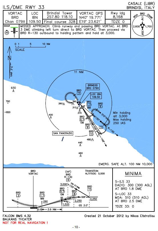
It is very clear in the header that said TDZE 0 FT, and NOT 48 as you state.
There is NO overview table in MAIPs, for sure you confuse this!
Nikos. -
your words are fine for real world.
But in BMS, they have no apply. I’m sure that you know that altimeter has readings of multiply of 10, right?Nope
the ground is at 0ft, but the altimeter will read 5-7 feet above that in the BMS cockpit
So it is implementedif tile elevation is 10 feet like at Kunsan
the aircraft will report 16 feet.
Best way to check it is to go external view and note the altitude
it will be airport elevation + height of the static port 10+6 = 16 feet -
@Red:
Nope
the ground is at 0ft, but the altimeter will read 5-7 feet above that in the BMS cockpit
So it is implementedO.k. here is a photo of cockpit in Casale of Balkans theater in BMS 4.33 U1. You can see that reads 0 FT (it is in BARO set).
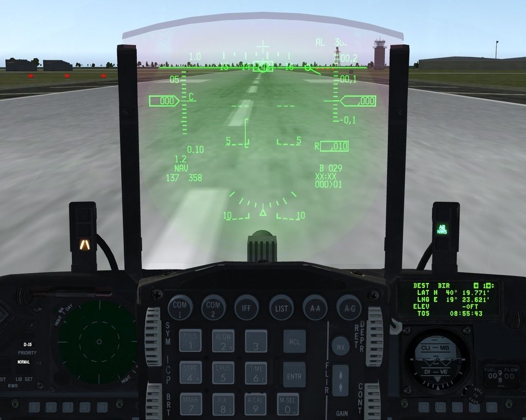
Can you please post a photo that show 5-7 FT or anything except of a multiply of 10 FT?
Nikos. -
re-read my message please
if tile elevation is 10 feet like at Kunsan
the aircraft will report 16 feet.
Best way to check it is to go external view and note the altitude
it will be airport elevation + height of the static port 10+6 = 16 feetI said altimeter, not HUD
Check your altimeter and you’ll see that it accounts the 6 feet difference
At least id does for me on Kunsan -
@Red:
re-read my message please
Copy that my friend.
But again, I was talking for altimeter reading, and not any other altitude infos.
Our words are still there…@Red:
Nope
the ground is at 0ft, but the altimeter will read 5-7 feet above that in the BMS cockpit
So it is implementedPlease don’t take wrong my words, no offending here.

Nikos. -
No worries. It’s sometimes hard to pass these small détails in writing
My point was if you want to check airport elevation to the slighest number, make sure you don’t take it from there unless you account for the 6 feet difference.
the best way to get airport elevation is the tile elevation from monster tool
(since the discussion above was about a possible mismatch in the airport elevation) -
@Red:
No worries. It’s sometimes hard to pass these small détails in writing
My point was if you want to check airport elevation to the slighest number, make sure you don’t take it from there unless you account for the 6 feet difference.
the best way to get airport elevation is the tile elevation from monster tool
(since the discussion above was about a possible mismatch in the airport elevation)recon should work as well.
in addition,
please remember that altimeter reading in BMS changes with temperature. -
@Nikos: I had the wrong document… the reference to an elevation of 48’ is in 1108_balkanNav.pdf (or similar).
All the best, Uwe


