Pusan RWY 14
-
Forgot to set the course on the HSI, Im guessing.
UFC course select is for the ILS in the HUD I believe, though Ive not actually used it for anything before.
-
This post is deleted! -
Which manual has info on TACAN? i probably will never need to use it in game but good to know and sounds interesting.
-
KTO_charts in your BMS folder
-
Which manual has info on TACAN? i probably will never need to use it in game but good to know and sounds interesting.
Also:
-
Forgot to set the course on the HSI, Im guessing.
UFC course select is for the ILS in the HUD I believe, though Ive not actually used it for anything before.
I can verify the course on the DED is for ILS depending on what runway you’re landing on and above course, freq is for the AB ILS freq so on that T-ILS page, whats left below TCN is related to TACAN and to the right below ILS is related to just ILS.
I’ve mastered ILS landing pretty much but TACAN i’m finding confusing…or maybe i just need more sleep so i can concentrate better!
-
-
Do all airbases and airstrips have TACAN stations? if so i can why i need to learn TACAN as it seems to me so far that only the south korean airbases have ILS freq. But then again how can you land without ILS and TACAN only?
-
Do all airbases and airstrips have TACAN stations? if so i can why i need to learn TACAN as it seems to me so far that only the south korean airbases have ILS freq. But then again how can you land without ILS and TACAN only?
I’m not sure how you’ve managed ‘proper’ ILS landings without proper use of TACAN …. they kind of go hand-in-hand int he sense that the TACAN gets you to a particular point where you are then set up to intercept and fly the ILS approach.
As far as a TACAN approach/landing, that is based on the charts provided by BMS. For example:
This basically says, use the TACAN to fly to the POSCO point, then, using the TACAN & HSI, fly an 11nm arch, then, using the TACAN & HSI and turn on to runway heading at ~11nm @ 3000 feet.
I think a TACAN approach would be considered a ‘non-precision approach’, whereas an ILS approach is a ‘precision approach’ (as far as I understand it).
Also, please refer to this folder as far as which airbases/airstrips do or don’t have TACAN or ILS: C:\Falcon BMS 4.32\Docs\Airport Approach & Navigation Charts
-
I’m not sure how you’ve managed ‘proper’ ILS landings without proper use of TACAN …. they kind of go hand-in-hand int he sense that the TACAN gets you to a particular point where you are then set up to intercept and fly the ILS approach.
As far as a TACAN approach/landing, that is based on the charts provided by BMS. For example:
This basically says, use the TACAN to fly to the POSCO point, then, using the TACAN & HSI, fly an 11nm arch, then, using the TACAN & HSI and turn on to runway heading at ~11nm @ 3000 feet.
I think a TACAN approach would be considered a ‘non-precision approach’, whereas an ILS approach is a ‘precision approach’ (as far as I understand it).
Also, please refer to this folder as far as which airbases/airstrips do or don’t have TACAN or ILS: C:\Falcon BMS 4.32\Docs\Airport Approach & Navigation Charts
I did it in the ILS landing TE. The steerpoint 1 is for homeplate so i fly to that and set up my ILS freq and course in DED (switch to ILS/NAV on mode selector to left of HSI). Once within 30nm of homeplate i contact tower and they say which runway i’m cleared for (sorry- this is where i input the relevant runway course heading on the DED) and once within 19nm i get the localizer and steering cue and the rest i do as explained in the video above (the top one for TACAN and ILS).
But i understand now what TACAN is for. In a campaign mission if your homeplate and alternate are destroyed/captured then you need to land elsewhere. But straight away you have a problem of finding the next nearest AB to land at if you dont know where you are, and to know where you are, you need to know where the bullseye is on the map, and have a compass. From your bullseye reading on your HUD you then with the map and compass find out where you are in relation to bullseye and then find the nearest AB to land (that hasnt been destroyed/captured…but how can you be sure?). Then for that AB you dig out the TACAN/ILS info and do as shown in that video above…though this will only be successful providing you have enough fuel to make it there, and you know it hasnt been destroyed/captured.
EDIT: Also need a ruler and the map has to be scaled i.e. 0.5cm=1nm to work out range from bullseye.
-
Do all airbases and airstrips have TACAN stations? if so i can why i need to learn TACAN as it seems to me so far that only the south korean airbases have ILS freq. But then again how can you land without ILS and TACAN only?
Hi there mate.
Well, first not all airbases/airports and airstrips have a TACAN station as in real life. Especially airstrips can’t have an ILS at this specific version of Falcon BMS, and by default nor a TACAN station. But can be placed manually a TACAN station near to airstrip by a developer if he wants to.
Second, you should learn and be familiar with TACAN approaches in order to can land your plane at airports that have no ILS system.
It isn’t too difficult to learn how to execute a TACAN approach, search for some good tutorials in youtube and make a lot of practise.
Nikos. -
Hi there mate.
Well, first not all airbases/airports and airstrips have a TACAN station as in real life. Especially airstrips can’t have an ILS at this specific version of Falcon BMS, and by default nor a TACAN station. But can be placed manually a TACAN station near to airstrip by a developer if he wants to.
Second, you should learn and be familiar with TACAN approaches in order to can land your plane at airports that have no ILS system.
It isn’t too difficult to learn how to execute a TACAN approach, search for some good tutorials in youtube and make a lot of practise.
Nikos.I see what you’re saying so whenever you do an ILS landing, you use TACAN to lineup with runway? cant you just have ATC guide you in then do an ILS approach? thats how i did ILS landings in the training TE.
-
Instrument Landing System is always a radio navigation aid which is the mechanical requirement on which the approach procedure depends. For every ILS there is at least one procedure to use that equipment. There is no ILS anywhere which is “here it is, use it however you like or whatever lol.” An approach is an approved method to get from the enroute structure to the landing. ATC can use vectors to shortcut you to the final segment but really you are always on a published approach procedure assuming this is ATC getting you onto an ILS. Vectors to final is an approved temporary deviation to join prior to the final segment. Of course there is nothing wrong with IFR visual approach so it all depends on what you’re cleared for.
Ignoring vectors which are a more subtle case, arriving at an airport IFR you might get assigned a specific published approach out of a book of them. Looking at this paper chart of how to do any practical example of an ILS approach there is always involved additional radio navaids like VOR or TACAN which make up the interesting part of the approach from the IAF to the FAF. If you look at a TACAN approach to the same runway usually they will look very similar to an ILS approach except lacking the final LOC/GS segment. Almost all ILS approaches are TACAN approaches which the ILS party trick stapled to the end. So if you understand non-precision approaches you are probably 90% of the way to understanding precision approaches. If you understand how to wander into an ILS beam with That Looks About Right technique then you don’t know much about instrument approaches at all.
-
I see what you’re saying so whenever you do an ILS landing, you use TACAN to lineup with runway? cant you just have ATC guide you in then do an ILS approach? thats how i did ILS landings in the training TE.
Well my friend,
You don’t use the TACAN station to line up with RWY (runway) in an ILS approach. You use it in order to be guided into the final segment of the approach, exactly at the specific point that you intercept the Localizer, and then the Glideslope.
See the below example of the ILS approach to Bandirma airbase in Aegean theater:
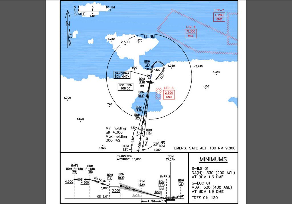
You can see that you follow the TACAN (BDM) Radial 188 inbound to station (with heading of 008 deg.) in order to intercept the Localizer course at 16 DME (or NM) and then you follow the Localizer course to an altitude of 3,000 FT MSL in order to intercept the Glideslope at 9.8 DME. Then you are good to continue a smooth and easy ILS final approach course.
But without that chart, you can’t be precise only following ATC vectors that are a general guide to RWY, especially with low fog.
In order to see that, just try to make an ILS approach to a desired airport but set low fog in order your visibility to be very poor. Then try to follow the ATC vectors to intercept the ILS Localizer and then the Glideslope.
After that, you will realize what i mean ;).
Nikos. -
Well my friend,
You don’t use the TACAN station to line up with RWY (runway) in an ILS approach. You use it in order to be guided into the final segment of the approach, exactly at the specific point that you intercept the Localizer, and then the Glideslope.
See the below example of the ILS approach to Bandirma airbase in Aegean theater:
http://i8.photobucket.com/albums/a40/neystratiou/LTBG_ILS01.jpgYou can see that you follow the TACAN (BDM) Radial 188 inbound to station (with heading of 008 deg.) in order to intercept the Localizer course at 16 DME (or NM) and then you follow the Localizer course to an altitude of 3,000 FT MSL in order to intercept the Glideslope at 9.8 DME. Then you are good to continue a smooth and easy ILS final approach course.
But without that chart, you can’t be precise only following ATC vectors that are a general guide to RWY, especially with low fog.
In order to see that, just try to make an ILS approach to a desired airport but set low fog in order your visibility to be very poor. Then try to follow the ATC vectors to intercept the ILS Localizer and then the Glideslope.
After that, you will realize what i mean ;).
Nikos.Well in the ILS training TE there is a low fog, theres’ only visibility of the ground at about 300 ft AGL. I guess in that it is set up so that you intercept the localizer without the need for TACAN (as it is just training for ILS and not TACAN). I’ll try it again later, this time i’ll fly about 35 nm away from the AB then turn back round to it so i’m perpendicular, then at 29nm out i’ll call ATC to get vectors to final and just see then if i intercept the loacalizer (and glideslope). I know that ATC get you on a final course to land at the desired runway, though its not precise by any means and i’m usually about 10nm out when they give me final approach vectors….and like you say the localizer needs to be intercepted at 16nm out. Well i’ll see for myself.
One problem to TACAN/ILS approaches though is when you contact ATC they’ll tell you which runway you’re cleared to land (which is important coz if you have no contact with ATC and you’re coming in to land at any runway you choose, you could crash with another aircraft which is landing/taking off)- and that can only be done once you’re within 30 miles. So then you’ll need to enter the correct course on the HSI for the radial of the runway and do your TACAN approach then. I guess this isnt really a problem but it would be better to know further out which runway you’re cleared to land on so you can start your TACAN approach earlier.
An alternative is to just call ATC and declare an emergency even though it isnt… -
In addition to the videos, there is a good document covering this topic in the docs folder of your bms install called Chart Tutorial. The F-16 has many tools for navigation and one could get away with never learning this stuff most of the time. But it is really cool to know how to use these tools when there is unexpected bad weather or when something gets bent like your mfds.
-
In addition to the videos, there is a good document covering this topic in the docs folder of your bms install called Chart Tutorial. The F-16 has many tools for navigation and one could get away with never learning this stuff most of the time. But it is really cool to know how to use these tools when there is unexpected bad weather or when something gets bent like your mfds.
Things getting bent, does this happen in BMS? so for example your INS/GPS fails so you no longer have your flight plan and can no longer select steer points.
-
Things getting bent, does this happen in BMS? so for example your INS/GPS fails so you no longer have your flight plan and can no longer select steer points.
Just go through some AAA and you will see for yourself

-
Well in the ILS training TE there is a low fog, theres’ only visibility of the ground at about 300 ft AGL. I guess in that it is set up so that you intercept the localizer without the need for TACAN (as it is just training for ILS and not TACAN). I’ll try it again later, this time i’ll fly about 35 nm away from the AB then turn back round to it so i’m perpendicular, then at 29nm out i’ll call ATC to get vectors to final and just see then if i intercept the loacalizer (and glideslope). I know that ATC get you on a final course to land at the desired runway, though its not precise by any means and i’m usually about 10nm out when they give me final approach vectors….and like you say the localizer needs to be intercepted at 16nm out. Well i’ll see for myself.
One problem to TACAN/ILS approaches though is when you contact ATC they’ll tell you which runway you’re cleared to land (which is important coz if you have no contact with ATC and you’re coming in to land at any runway you choose, you could crash with another aircraft which is landing/taking off)- and that can only be done once you’re within 30 miles. So then you’ll need to enter the correct course on the HSI for the radial of the runway and do your TACAN approach then. I guess this isnt really a problem but it would be better to know further out which runway you’re cleared to land on so you can start your TACAN approach earlier.
An alternative is to just call ATC and declare an emergency even though it isnt…I think that you misunderstood something here. You said “and like you say the localizer needs to be intercepted at 16nm out.” but that is not correct at all.
The specific words are ONLY for the specific procedure of ILS to RWY 01 of Bandirma airbase in Aegean theater!
Please keep in mind that each one procedure is unique. Of course the methodology is the same, but you don’t always have exactly the same DME, the same altitude and the same final course in all procedures.
See below the ILS approach procedure to RWY 03 of Aviano airbase:
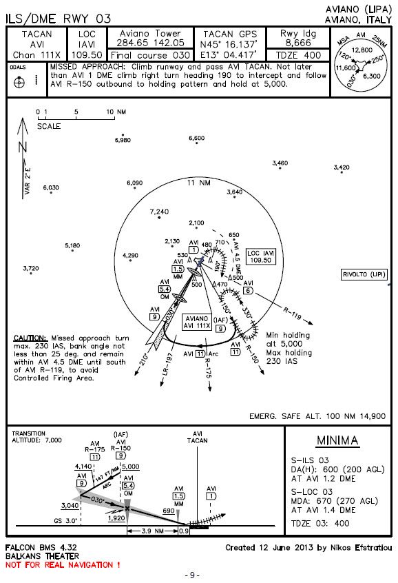
Here you can see that we intercept the Localizer and the Glideslope course at 9 DME after a right turn exiting the 11 DME arc.
Nikos. -
I think that you misunderstood something here. You said “and like you say the localizer needs to be intercepted at 16nm out.” but that is not correct at all.
The specific words are ONLY for the specific procedure of ILS to RWY 01 of Bandirma airbase in Aegean theater!
Please keep in mind that each one procedure is unique. Of course the methodology is the same, but you don’t always have exactly the same DME, the same altitude and the same final course in all procedures.
See below the ILS approach procedure to RWY 03 of Aviano airbase:
http://i8.photobucket.com/albums/a40/neystratiou/Aviano_ILS_final.jpgHere you can see that we intercept the Localizer and the Glideslope course at 9 DME after a right turn exiting the 11 DME arc.
Nikos.Ok i have some questions,
How do i know what heading i need to be on before the right turn at DME 11? so for example i’m coming in to land and i’m 30nm away. I’ve entered the TACAN and ILS info for Aviano RWY 03 on my DED, and selected TCN/ILS on mode selector next to HSI. Do i then follow the station pointer arrow on the HSI so its at my 12 o’clock? and will my heading once i’m on that arrow be 150 degrees? (from what i can make out on that chart) then just wait till i’m 11 miles out with CDI showing at 6 o’clock to my ownship? then turn right, but how many degrees do i bank?
Also on that chart, how can i tell where i intercept the localizer and glidescope? you say i intercept both at 9 DME but theres’ nothing saying that. On the chart for Bandirma above also, theres’ nothing saying the localizer is intercepted at 16 DME and glidescope at 9.8.
Also noticed both charts are different in that Bandirma is just for the ILS approach where for Aviano it has TACAN and ILS.
