Altimeter query.
-
but in lower airspaces it is necessary all planes of the location use the same barometric pressure for division (while above specified height all planes have to use QNE).
-
Hello Forum.
When performing a night / low visibility ILS landing, flying an arc DME, it’s possible to wander to the right or left of the arc. With high ground in the vicinity, should one use the radar altimeter in preference to the barometric version?
Thanks,
Bayonet.When you follow a terminal procedure to land (ILS or TACAN/VORTAC one) your ONLY way is the usage of barometric altitude with local QNH from the tower of the airport that you want to land. No room for argument here, IF we want to say “as real as it gets”!
Even if the airport is surrounding with high mountains or any other dangerous obstacles, the procedure created with them in consideration and has a completely safe path for all of its track!
Now if the desired airport has no published terminal procedure, this is an other story…
Last for the guys that may suggest also the usage of radar altimeter in an area with high obstacles (like mountains), they must think that sometimes the popography of an area has a very steep changes in the altitude of the terrain that leaves to the pilot a very small amount of time to react after the reading to the radar altimeter ;).
Nikos. -
Neystratiou is right. Fly the published approach and you are clear of obstacles. Radar altitude is the height you have now but does not predict the cliff you are flying towards. So radar altitude is a is a bad replacement of good planning. This is also the case (or especially) with a bombing run.
So bottum line: use baro with QNH and fly your planned flightpath.
")
-
P.S. wrong name
Haha, no you were just fine.
Nikos is my name, and I like to use (and be used) my real name instead of my callsign :).
Nikos. -
Was not sure so I thought Oops
Good to know -
When you follow a terminal procedure to land (ILS or TACAN/VORTAC one) your ONLY way is the usage of barometric altitude with local QNH from the tower of the airport that you want to land. No room for argument here, IF we want to say “as real as it gets”!
Even if the airport is surrounding with high mountains or any other dangerous obstacles, the procedure created with them in consideration and has a completely safe path for all of its track!I agree with you 100% but his scenario had him straying from the published track… granted he didn’t mention how far he was straying but he didn’t mention which airbase as well.
If he can fly the track and stray maybe 1-1.5nm from the path, then he should be fine. If he strays further out and the radar altimeter is telling him something else, well, like I said, terra firma has a Pk of 100%! -
I agree with you 100% but his scenario had him straying from the published track… granted he didn’t mention how far he was straying but he didn’t mention which airbase as well.
If he can fly the track and stray maybe 1-1.5nm from the path, then he should be fine. If he strays further out and the radar altimeter is telling him something else, well, like I said, terra firma has a Pk of 100%!Well, again my dear friend you will NOT rely on the radar altimeter.
Your next step in the case that you are offset of the defined track of the procedure is to climb as soon as possible to the minimun safe/sector altitude, as defined in the chart.
Then if you have a human ATC controller you can be guided by him on your next action (to holding or to a new approach) or you will find the way (with safety in mind) to the holding first (assuming that your fuel let you do this) and then with checking the nearby traffic and informing at the proper ATC frequency try your new approach ;).
Nikos. -
Anyway, correct me if I’m wrong, but shouldn’t you be flying at an altitude that clears all known nearby terrain anyway? What airbase was home plate?
Your next step in the case that you are offset of the defined track of the procedure is to climb as soon as possible to the minimun safe/sector altitude, as defined in the chart.
-
The barometric altimeter is the reference instrument. If you were found to be using the radio altimeter instead of baro as primary reference that would get your fired from any airline or air force. Upon returning home you get QNH (or QFE if your air force is still in the stone age) from the controller immediately before beginning the approach. You don’t assume it’s the same as when you took off a few hours ago.
The only time the radio alt is primary reference is for DH on Cat II/III approach which the F-16 is not rated for. There’s absolutely nothing wrong about crosschecking with it but for example if there is a mandatory crossing altitude and the baro and radio disagree, the baro is right.
-
That made me a little curious Frederf, why not QFE?
I mean, 0 on baro altimeter should be runway right?No, I’m not educated on Q-codes
-
@theOden:
That made me a little curious Frederf, why not QFE?
I mean, 0 on baro altimeter should be runway right?No, I’m not educated on Q-codes
Well you have right about QFE and barometric altimeter that will read 0 at runway.
Now why they (departments and ICAO and rest…) have chosen the usage of QNH instead of QFE, my guess is for traffic deconfliction at close airports.
Think 2 airports very close but with different RWY elevation. Then the aircrafts from them (approaching and departuring) that will be exactly at the same altitude, will gone have/say different numbers of altitude according to their ATC QFE, means chaos…
Nikos. -
That’s it, and also for security reason. Some accidents already append because a wrong QFE has been entered from a terrain A to a terrain B with two different elevation.
For example that one : -
QFE operations are largely a thing of the past. It was popular with the Soviets, RAF, and several commercial airlines (being the latest examples I know of). As a practice it required less brain work at the expense of less true understanding of the situation. Like setting your watch 5 minutes fast to trick yourself into being early it’s only a matter of time until a mistake is made by lying to yourself with the instrument. While it takes more information held in the mind at once it’s more or less resolved worldwide QNH is superior to set the altimeter as close to truth as possible and accept having to think about more numbers. Due to the fun that is altimetry a plane flying 5000’ MSL above a 100’ elevation airport and a plane flying 4900’ on a QFE setting aren’t exactly equivalent, although in practice they’d be close. But the merits of QFE v. QNH operations aside the supplied approach plates, most if not all air forces that fly the F-16, and if it was modeled in more detail the airplane itself is predicated on QNH operations (I think the takeoff roll does an A-CAL snapshot which relies on the altimeter to read as close as possible to true or maybe that’s just the A-10).
I’ve never seen a QFE-compatible approach procedure and would be interested in seeing one.
-
Ice, you’re perfectly correct,no argument. Use all tools.
“What airbase was home plate”……while my query was generic to the context, I just happened to be using Choongwon.
As you will know the DME arc moves over very undulating ground and both altimeters will vary in read out.
Thanks for your input.Bayonet.
-
I’ve never seen a QFE-compatible approach procedure and would be interested in seeing one.
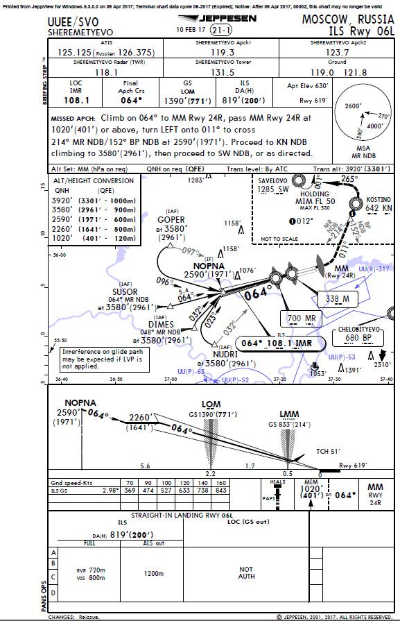
Though these charts are almost 10 years old, an example is that Sheremetyevo, Moscow, Russia used QFE (unknown to me if they still do) alongside QNH.
-
Though these charts are almost 10 years old, an example is that Sheremetyevo, Moscow, Russia used QFE (unknown to me if they still do) alongside QNH.
Yes, it still use QFE
")
Nikos.
-
This post is deleted!
