Guantanamo Theater
-
https://i.postimg.cc/PJg45cBX/MC-editing-te-new-tac.jpg
Dealing with MC to edit my te_new.tac so I can change under the “campaing” label guantanamo instead of korea.
My .csv generated with Dem2Terrain is not working in MC. Maybe I need to get this with an older file format for the .tac and using TacEdit, or adapt the old one to a .csv format MC will accept.
You can use it with Tacedit! Save your save0 without any objectives or whatever as version 73. Close MC and run Tacedit. load the saved save0 then go to objectives on the top and click import objectives and load the dem2terrain generated csv. Save as you want and the open it with MC and resave it normally as version 100
If you do it correctly you will have all objectives imported!Cheers
-
You can use it with Tacedit! Save your save0 without any objectives or whatever as version 73. Close MC and run Tacedit. load the saved save0 then go to objectives on the top and click import objectives and load the dem2terrain generated csv. Save as you want and the open it with MC and resave it normally as version 100
If you do it correctly you will have all objectives imported!Cheers
YES! This did work.
I did it this way:
a) Save the save0.cam in MC as version 73 without touching nothing.
b) Open in TacEdit
c) Delete all Objectives
d) Delete all Airbases
e) Import from my csv
f) Save it.
g)Open in MC and allow a fix on a missing squadron or something like that
h) Change now from the campaign tab my theater name to guantanamo and save as v100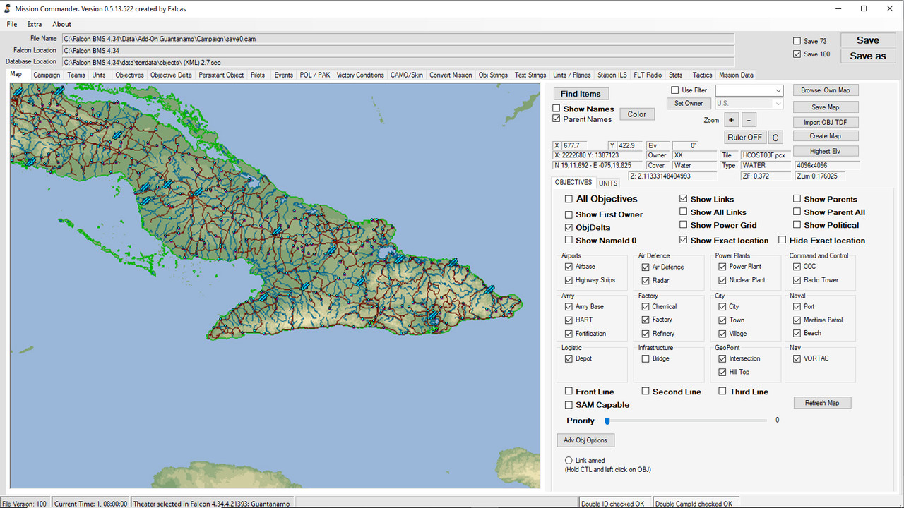
Thanks again Manos!
-
Ok, not much advancement this weekend. I have been digging into the e00 file, also fiddling with other software to try to “sanitize” my e00 files so that they don’t generate so many (actually everything but airports) NoName objectives. This has been time consuming and not very productive for now.
-
Allright. For now I left aside all the NoName troubles and have focused on having a small flight in the Terrain to see how it is:
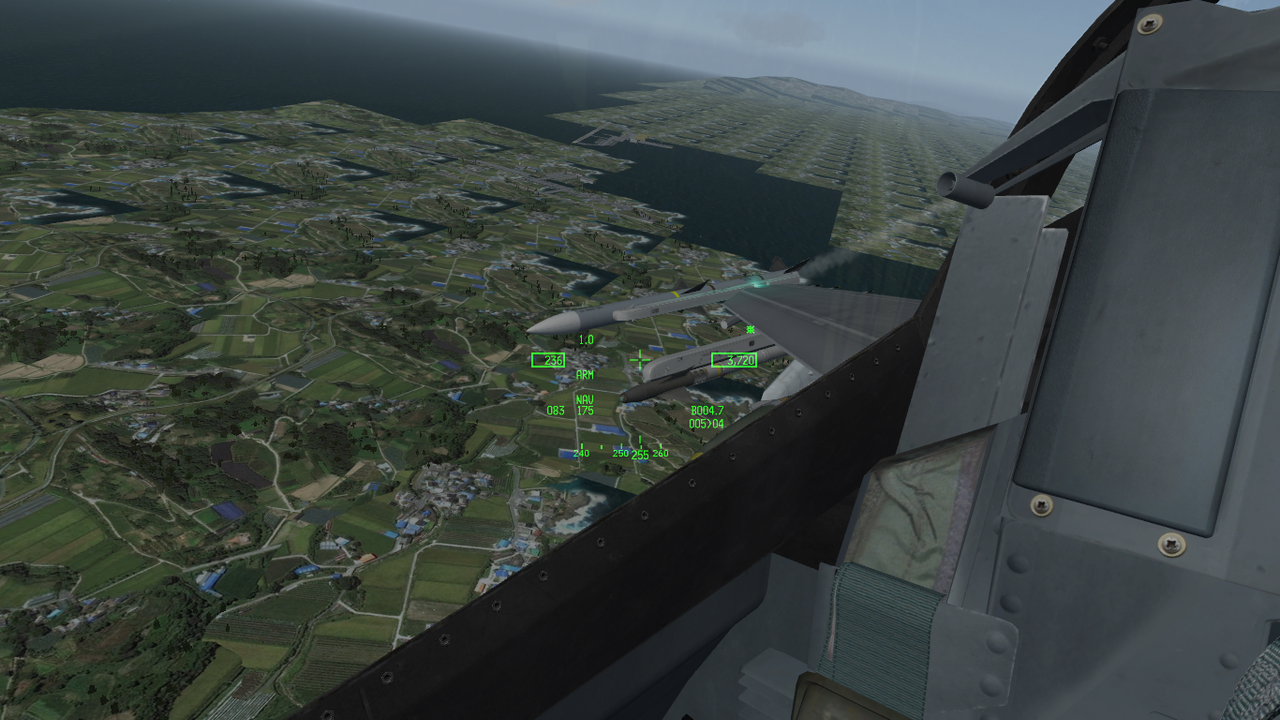
Yep! Thats suppoused to be McCalla and Leeward in Guantanamo Bay… and Sierra Maestra can be seen in the back
Lots of ugly tiling… but it works in sim!
-
Wow, good job !
-
Last night I was a bit looking into CATE and reflecting on It I thought I needed to look at the satellite images to have some ideas on what to do for tiling.
So I thought about using SAS Planet to look at It and at least get Guantanamo bay un photorealistic.
I needed to update my gogl maps settings there so I used as reference
(Self reference) [emoji2371]
cellphone
-
Ok, for what I have understood so far, in order for CATE to work I would have to have an image (.BMP I Guess) of my theater where each pixel represents a tile.
Sooo if my Theater is 64 segments wide and 64 height and each segment is also 16 tiles by 16 tiles….
64x16=1024 pixels wide.
Therefore for my theater I need to grnerate a 1024×1024 bitmap where each RGB color pixel represents a type of tile.
I would have to tell cate by script what to do when It founds color XYZ (RGB) etc…
Sounds easy… and I am sure It wont be.
cellphone
-
The noname are all noname or some?
If they have parents and those parents are named then it’s a piece of cake to name them, depending on the category…
For example bridges that many theaters have them like noname or 0 it’s super easy to baptize them all at once automatically. -
Unfortunelly they are all the Villages and cities.
cellphone
-
Ok, for what I have understood so far, in order for CATE to work I would have to have an image (.BMP I Guess) of my theater where each pixel represents a tile.
Sooo if my Theater is 64 segments wide and 64 height and each segment is also 16 tiles by 16 tiles….
64x16=1024 pixels wide.
Therefore for my theater I need to grnerate a 1024×1024 bitmap where each RGB color pixel represents a type of tile.
I would have to tell cate by script what to do when It founds color XYZ (RGB) etc…
Sounds easy… and I am sure It wont be.
cellphone
Using a .bmp is just one way to define the tiles.
The strength of CATE is to tile the terrain according to elevation basicly,
then according to features like roads, rivers (little buggy), airbases etc., including their
transition tiles.Multible differently scripts, executed in correct order can do much tiling work here.
For example, usally for terrain the sea level is at 0ft, so you can already tile Ocean and Land.
The first script use only those 2 plain tiles to tile Ocean at 0ft and Land for anything higher.
The second script place the transition tiles between Ocean and Land.Look at the CATE manual for howto write such scripts.
I’m sure you’ll figure it out.")
Cheers, :yo:
LSmy Rig:
Alienware "Aurora" I7-960 3,2 GHz / 18 GB DDR3 / GeForce 1070 GTX 8GB /
1x500 GB SSD / 1x2 TB SATA II (1x1,5 TB SATA II for backup)
Hotas Cougar Nr.:16387 / FCC-3 / Elite Rudder pedals / TrackIR4 / Win10 x64 Home -
Thanks for the tip!
What looks promising is also the variation thing…!
cellphone
-
The noname are all noname or some?
If they have parents and those parents are named then it’s a piece of cake to name them, depending on the category…
For example bridges that many theaters have them like noname or 0 it’s super easy to baptize them all at once automatically.Yup +1 on this.
What i did was to convert most of the noname to factories,refineries,junctions etc and then baptise them by their parent. Its a bit time consuming specially when they are many but its a good solution i believeTοις τολμώσιν η τύχη ξύμφορός εστιν (Luck helps those who dare - Thucydides)

-
Using a .bmp is just one way to define the tiles.
The strength of CATE is to tile the terrain according to elevation basicly,
then according to features like roads, rivers (little buggy), airbases etc., including their
transition tiles.Multible differently scripts, executed in correct order can do much tiling work here.
For example, usally for terrain the sea level is at 0ft, so you can already tile Ocean and Land.
The first script use only those 2 plain tiles to tile Ocean at 0ft and Land for anything higher.
The second script place the transition tiles between Ocean and Land.Look at the CATE manual for howto write such scripts.
I’m sure you’ll figure it out.
Cheers, :yo:
LSLazy i read that in bmp mode u can actually tell cate also make roads and rivers? did i read correctly or missunderstood?
Another lets say problem i have is when i run the features conf for roads and rivers it completely ignores the transitions and messes the city tiles by placing the roads. (with rivers its ok) Is there any solution to this?Thanks!
Tοις τολμώσιν η τύχη ξύμφορός εστιν (Luck helps those who dare - Thucydides)
-
Yup +1 on this.
What i did was to convert most of the noname to factories,refineries,junctions etc and then baptise them by their parent. Its a bit time consuming specially when they are many but its a good solution i believeNo time consuming at all m8 if you do it in excel. just a few seconds.
Bellow in first column (RED) it was all bridges named as 0.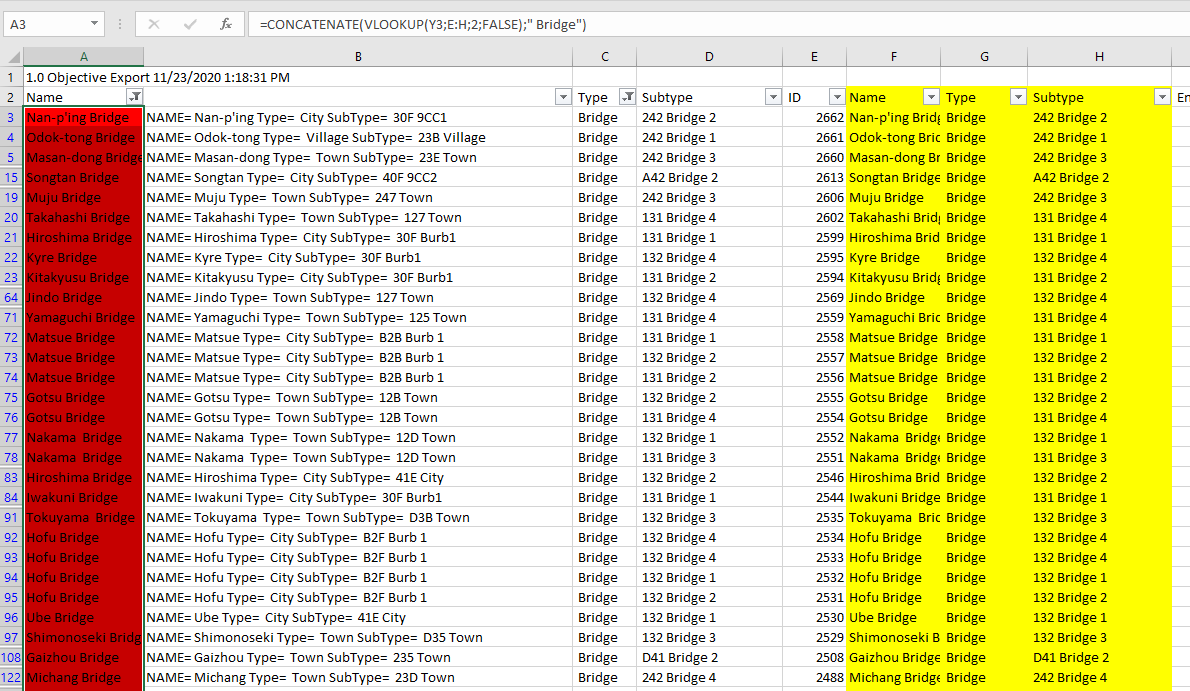
First export from MC to csv, or if you have them as csv or excel.
add one column after the ID column.
On that empty column copy and paste the Name column, don’t erase the first Name column.
Filter the whole list, Data->filter.
Filter your selection to display noname or 0 or whatever you want to replace with the parent name.
in the name column on the first cell insert the formula:=CONCATENATE(VLOOKUP(V3;E:F;2;FALSE);" Bridge")
press enter and then drag the cell all the way down to fill all the raws in the column.
ready.
If you want the values, instead of the formula in the cells, just select the cells with the formula, right click copy, right click paste values.For the formula, important, depending on your locale it could be ; or , that separate the formula parts.
so the formula could be:=CONCATENATE(VLOOKUP(V3,E:F,2,FALSE)," Bridge")
This is a nested formula where we concatenate or merge if u like the result of a search match (vlookup) with the text " Bridge"
So vlookup will search based on the value of V3 which is the parent ID column inside E:F columns and always on the first column which is E, once found a result we tell it to return 2 which means the second column (F) from E:F set, which has the names, we add FALSE in vlookup at the end which dictates vlookup to find an exact match only. If you don’t add false u r in trouble as it will return anything familiar or close to the search value.I use such at work everyday for decades and I write those blindfolded and I recall first times was a pain to comprehend… don’t worry excel is very good guiding you once you press the fx button, and provides a form to input or select via mouse.
it literally takes a few seconds… so Manos sorry you had to do it one by one…One more reason I bark to ask in the public forum… don’t fight the beast alone… I know that there are new tools and tricks added to do one job but this is the monster and this is how we fight it…
Unfortunately we can’t avoid the reinvention of wheel in the process cause the spread of knowledge is vast, but we can help each other and no one knows all…Edit: in my picture I have different cell values in the formula cause I added 3 columns… V3 or Y3 in the pic is the column that has the parent ID, so type this column in your formula.
Edit2: also in the pic in column F you see already the nae with Bridge, this is because I used a formula =A1, so initially it was 0, but once I added the formula it returned the formula result… don’t get confused by this, just ignore it. Also on B column I just concatenated (merged) some columns to have them as reference and cross check the type mostly.HOT LIST

System Specs:
i7-2600K @ 4.8 Ghz WaterCooled / 32GB Ram. 2TB SSD/1TB SSD / 20TB HDD Total / GTX1080Ti 11GB DDR5X / HOTAS COUGAR. TrackIR 4 / 3x24" Mon. (res:5760x1200) / Cougar MFD's / Wheel Pedals / Win 10 64 bit.

-
No time consuming at all m8 if you do it in excel. just a few seconds.
Bellow in first column (RED) it was all bridges named as 0.https://i.postimg.cc/3wPxQYzf/unknown.png
First export from MC to csv, or if you have them as csv or excel.
add one column after the ID column.
On that empty column copy and paste the Name column, don’t erase the first Name column.
Filter the whole list, Data->filter.
Filter your selection to display noname or 0 or whatever you want to replace with the parent name.
in the name column on the first cell insert the formula:=CONCATENATE(VLOOKUP(V3;E:F;2;FALSE);" Bridge")
press enter and then drag the cell all the way down to fill all the raws in the column.
ready.
If you want the values, instead of the formula in the cells, just select the cells with the formula, right click copy, right click paste values.For the formula, important, depending on your locale it could be ; or , that separate the formula parts.
so the formula could be:=CONCATENATE(VLOOKUP(V3,E:F,2,FALSE)," Bridge")
This is a nested formula where we concatenate or merge if u like the result of a search match (vlookup) with the text " Bridge"
So vlookup will search based on the value of V3 which is the parent ID column inside E:F columns and always on the first column which is E, once found a result we tell it to return 2 which means the second column (F) from E:F set, which has the names, we add FALSE in vlookup at the end which dictates vlookup to find an exact match only. If you don’t add false u r in trouble as it will return anything familiar or close to the search value.I use such at work everyday for decades and I write those blindfolded and I recall first times was a pain to comprehend… don’t worry excel is very good guiding you once you press the fx button, and provides a form to input or select via mouse.
it literally takes a few seconds… so Manos sorry you had to do it one by one…One more reason I bark to ask in the public forum… don’t fight the beast alone… I know that there are new tools and tricks added to do one job but this is the monster and this is how we fight it…
Unfortunately we can’t avoid the reinvention of wheel in the process cause the spread of knowledge is vast, but we can help each other and no one knows all…Edit: in my picture I have different cell values in the formula cause I added 3 columns… V3 or Y3 in the pic is the column that has the parent ID, so type this column in your formula.
Edit2: also in the pic in column F you see already the nae with Bridge, this is because I used a formula =A1, so initially it was 0, but once I added the formula it returned the formula result… don’t get confused by this, just ignore it. Also on B column I just concatenated (merged) some columns to have them as reference and cross check the type mostly. +1 for the info!
Maybe u can help with CATE issue as well ? I found a way but still it “eats” some of the city transition files. Far more managable than spliting a city in half to lay road tiles but still it would be far more awesome if it wouldn’t happen at all!!!Cheers
-
Lazy i read that in bmp mode u can actually tell cate also make roads and rivers? did i read correctly or missunderstood?
Another lets say problem i have is when i run the features conf for roads and rivers it completely ignores the transitions and messes the city tiles by placing the roads. (with rivers its ok) Is there any solution to this?Thanks!
Beside that RGB xxx is tile number x, there is no tiling logic in BMP mode.
Tiling the roads/rivers (RR) has been always a bit messy and tricky with CATE,
and the more tiles comes into play, the worse it might get.If I would tile a terrain totay, I would tile plain ocean, land, and cities
without any transitions first. (to keep it simple for RR tiling algorithm)Then RR, without any transitions.
Next the transitions for RR, then the transitions for ocean to land
and city to land.Note: the RR “interact” with each other, so the transitions for the RR
needs separated scripts, one for rivers, one for roads.Then correct tiling errors using the replace function in Monsters TE.
This would be a good base for further tiling.
Forest for example could be painted then on the BMP and tiled on land tiles only,
Next change land RR and land cities to forest RR and forest city tiles.Then tile forest transitions.
… and go from there …
Cheers, :yo:
LS -
Thanks LS!
It seems i was doing it worng all this time then i figure out what exactly those numbers mean in the RR conf file! LOL and also had an flash of the read me…
Everything now seems perfect!Cheers!
-
Well, I am no yet dead… Neither is this project.
I have been trying to solve the “NoName” issue that is give to all my objectives Cuban places.e00.
I have also reworked some things to include part on Florida (Key West for sure) and Bahamas.
Still WIP
-
Well, I am no yet dead… Neither is this project.
I have been trying to solve the “NoName” issue that is give to all my objectives Cuban places.e00.
I have also reworked some things to include part on Florida (Key West for sure) and Bahamas.
Still WIP
no name as???
e00 can be loaded in QGIS.
U can load a ton of GIS data in qgis.
I’m like 99% sure that your points will be the same as let’s say OSM data…
so for those overlapping get the OSM names, and please please don’t do it by hand, one by one…HOT LIST
System Specs:
i7-2600K @ 4.8 Ghz WaterCooled / 32GB Ram. 2TB SSD/1TB SSD / 20TB HDD Total / GTX1080Ti 11GB DDR5X / HOTAS COUGAR. TrackIR 4 / 3x24" Mon. (res:5760x1200) / Cougar MFD's / Wheel Pedals / Win 10 64 bit.
-
I finally solved It. I Will explain how in another post.
The thing about using other sources is two problems: Dem2Terrain converst all objectives to XY tile coordinates and also removes all objectives that are out of the frame of the theater but part of the country/U.S state.
So yes. Names are there (OSM and others) but will require such conversion from lat-long coordinAtes to XY tiles, and later on a removal.
Also Dem2Terrain generates the factories and probably other stuff out of the labels.e00 files which only has the names of cities and Villages…
cellphone