Block 52+ Advanced moving digital map
-
Are you not content with the current version of the F16?
I guess that many of our friends here are mastering all current avionic systems proposed by BMS!
BMS’s avionics is no more a secret for them and they knows all details and begin to be bored with current BMS modeled version…It is certainly why they wants all latest updates with new systems and more complex stuff.
Personally, I am impressed because I’m still learning every day … and even with around 2000H since 1998, I still need periodic trainings to keep my skills at an “acceptable” level.
ASUSTeK ROG MAXIMUS X HERO / Intel Core i5-8600K (4.6 GHz) / NVIDIA GeForce RTX 3080 Ti FE 12GB / 32GB DDR4 Ballistix Elite 3200 MHz / Samsung SSD 970 EVO Plus 2TB / Be Quiet! Straight Power 11 1000W Platinum / Windows 10 Home 64-bit / HOTAS Cougar FSSB R1 (Warthog grip) / SIMPED / MFD Cougar / ViperGear ICP / SimShaker JetPad / Track IR 5 / Curved LED 27'' Monitor 1080p Samsung C27F396 / HP Reverb G2 VR Headset.
-
I guess that many of our friends here are mastering all current avionic systems proposed by BMS!
BMS’s avionics is no more a secret for them and they knows all details and begin to be bored with current BMS modeled version…It is certainly why they wants all latest updates with new systems and more complex stuff.
Personally, I am impressed because I’m still learning every day … and even with around 2000H since 1998, I still need periodic trainings to keep my skills at an “acceptable” level.
I’m very impressed too with their master skills, wish they could teach me …. oh i forgot they are to busy flying for FUN … hmmmm FUN
Spooky
-
It’s amazing that if you’re not flying every week you actually get rusty. Walk away for 4 weeks and it takes 3-4 flights to get comfortable again!
Dee-Jay, 2000 Hours since 1998? I suggest a steady flight schedule of 20-30 hours a week!
-
Dee-Jay, 2000 Hours since 1998? I suggest a steady flight schedule of 20-30 hours a week!
I made a long pause between 2001 and 2005 during my RL pilot formation.
So …
1998 to 2012 = 14years (-4years) = 10years
10*52 = 520weeks … 2000/520 = 3.8h/week
-
@SkyKnight:
Hi I gather you missed this …. Click link
Silly meeeeee I guess…:oops:
Cheers,
:drink:
Since nobody has announce that they are buying that version (specially not the US) and since it don’t exist (only a propose model like the F-16IN) how does that relate at all to his comment?
@Migbuster:I suspect US birds wont have this anyway till the V upgrade comes in.
I can only assume he is referring to the Peace (insert appropriate name here, e.g. Xenia for Greece, Gate for Pakistan, etc) but those are only related to foreign aircraft sale and not related to USAF blocks ( and modifications) But since I do not know what he meant, I guess I will have to wait for his answer.
-
Let me put my two cents. We have larger MFDs called MPDs in the 64. Block II aircraft with later Lot software series have moving map displays. It was painful to use them. You always had to declutter MPDs, zoom in zoom out to see clearly what’s on the map, green lines always blurred in with yellowish maps, constantly adjusted brightness. I always ended up turning the map overlay off. Never used VFR cross sectionals as overlays anyways, you’d need tactical maps. So as far realism goes, don’t implement maps don’t exist in the real thing just for the sake of having a map.
-
supposedly an ang block30 with digital moving map, first sight at 4minute mark and so on:
-
Not the same for the block 30 but yes, nearly the same idea behind. On the block 30 SCU tape, it’s call “TAD” instead of “HSD”. But a lot of things is different avionics wise about the block 30. Even the cockpit is a mess :p.
-
Not the same for the block 30 but yes, nearly the same idea behind. On the block 30 SCU tape, it’s call “TAD” instead of “HSD”. But a lot of things is different avionics wise about the block 30. Even the cockpit is a mess :p.
yep, obviously their ang block30s in particular are a special breed. but the capability’s still there none the less.
-
supposedly an ang block30 with digital moving map, first sight at 4minute mark and so on:
6:O4 minutes is the best.
")
Sorry for OT.
-
What a heck is that smoke in cockpit?
-
-
yeap the same reason one crashed off the runway cause the pilot couldn’t see clear the HUD on touchdown… I believe they overdone it… surly it’s obvious that in extreme conditions creates visual problems. they should had the out somewhere else and not covering the hud…
HOT LIST

System Specs:
i7-2600K @ 4.8 Ghz WaterCooled / 32GB Ram. 128GB SSD/1TB SSD / GTX1080Ti 11GB DDR5X / HOTAS COUGAR. TrackIR 4 / 3x24" Mon. (res:5760x1200) / Cougar MFD's / Wheel Pedals / Win 10 64 bit.

-
Let me put my two cents. We have larger MFDs called MPDs in the 64. Block II aircraft with later Lot software series have moving map displays. It was painful to use them. You always had to declutter MPDs, zoom in zoom out to see clearly what’s on the map, green lines always blurred in with yellowish maps, constantly adjusted brightness. I always ended up turning the map overlay off. Never used VFR cross sectionals as overlays anyways, you’d need tactical maps. So as far realism goes, don’t implement maps don’t exist in the real thing just for the sake of having a map.
+1
If you want digital moving maps go buy an iPad for a kneepad and a GPS for your canopy, install Jeppesen stuff anf you are ready for fun.
So, how many in here have experience with this specific HSD digital map? Please raise your hands.

-
So, how many in here have experience with this specific HSD digital map? Please raise your hands.
Yes, I have experience with the TAD from the A10C-sim and the Abris from the Ka-50 but I dont miss a moving map in the F-16.
95% of the A2G missions for the F-16 are preplanned therefore we should already know where we will fly etc.
-
2¢ - the Hornet’s digital moving map on the MPCD is very user friendly and easy to read. The HSI format is mainly used for navigation and the SA format is mainly used in the tactical enviroment. Biggest issue is that the map is bright at night but you can turn it off to help alleviate that issue.
I can see how making a digital moving map work on a computer monitor would require a high resolution though.
I’m thinking the software should be very similar since we both have experience in Boeing aircraft so that makes me think maybe I just didn’t like the presentation. Turning down the brightness of the overlay made it useless at times. If symbology was darker or at least adjustable maybe that would have helped. But yeah sometimes you had to look at the map since we didn’t carry print maps like other guys. My point stands, BMS should implement it as it’s in the real thing.
-
95% of the A2G missions for the F-16 are preplanned therefore we should already know where we will fly etc.
Small correction, 100% of all missions in all aircraft IRL are very thoroughly planned. Now if someone does not want to prepare at all before a BMS mission that’s another story. The map will still not help you IMO.
I’ve also used the map in A-10C, I usually ended up turning it off so I could actually read the symbology and even when I left it on I didn’t actually use it for anything.
My point stands, BMS should implement it as it’s in the real thing.
Can’t argue with that, the question is, which one of all the variants of the real thing?
At least until we have block/country specific avionics if ever. -
USAF F-16CJ of course what else is out there … LOL LOL:D
-
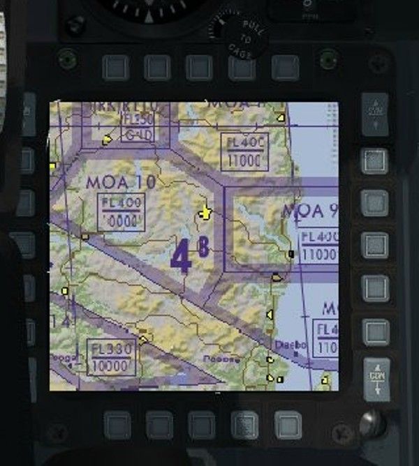
Hi all,
Just adding pics and info to thread!
The Benefits
Situational awareness, relative information, colored identified objects, and specific symbols, visible airbases, real-time information, visible mountain terrain elevation for defensive masking, targets relative to ground view or terrain, proper route or alternate route steer point and visible roads especially whilst flying at night.
What it is
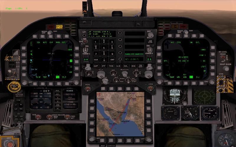
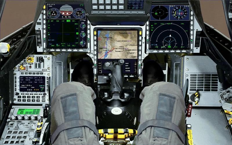
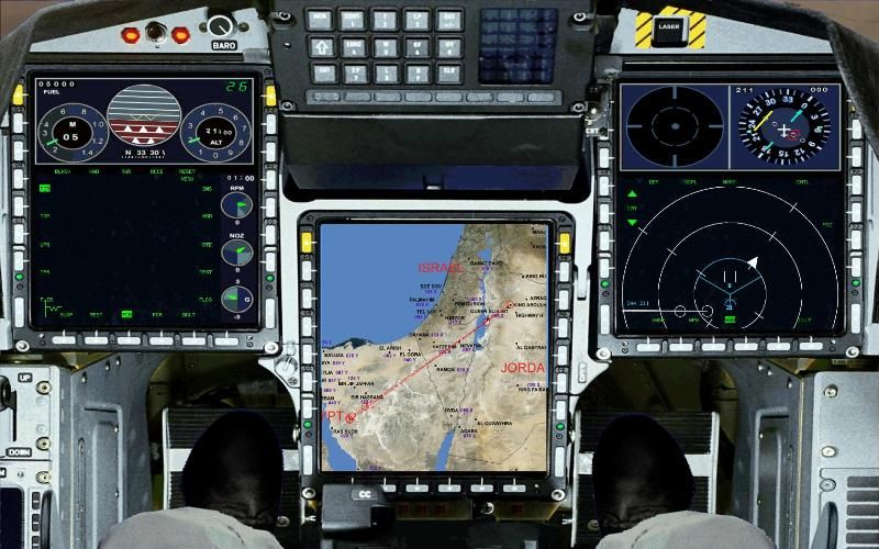
The Horizontal Situation Display (HSD) is one of the most important pages available on your MFD. It is a moving-map display of the current horizontal situation around you, showing friendly and enemy aircraft, the route you are flying, the area being scanned by your radar, and many other useful pieces of information. The HSD is used to maintain situational awareness of your present location and of what is happening around you in the air and on the ground.
Basic Symbology
You can imagine the HSD as what you would see if you were directly above your aircraft, looking straight down. There are three range rings, each representing one third of the currently selected display range (so for example, if you have selected 15 miles, each ring is another increment of 5 miles. If you have selected 60 miles, each ring is another increment of 20 miles). Your aircraft is in the center of these range rings, and the map is oriented so that your aircraft’s heading is straight up. Each range ring has four spokes, representing north, east, west, and south. The north spoke on the innermost range ring is replaced with a solid white triangle, to show you what your heading is.
Your navigational course is displayed on the HSD. Each steerpoint is displayed as white shape, with the currently selected steerpoint flashing. The shape of the steerpoint symbol depends on the type of steerpoint - normal steerpoints are circles, insertion points are squares, and target/CAP steerpoints are triangles. A white line is drawn between each steerpoint, giving you a birds-eye view of your complete flight path. You can navigate to a particular steerpoint simply by turning so that the steerpoint is located directly above your aircraft on the HSD, and then flying that heading.
The area that your radar is scanning is displayed using a cyan box, taking into account your sweep angle, selected range, and antenna orientation. A “ghost cursor” is also displayed, which shows the geographical area that your radar cursor is currently in. This is useful for getting a sense of what area your radar is looking at, and can also be used to help identify targets (if you have a radar spike in a portion of the radar scan area that is over known enemy locations, it’s probably an enemy). Note that the scan area can extend further than the HSD displays, in which case the cyan lines will simply continue off the HSD.
Known enemy positions are uploaded into your aircraft’s computer before you take off - these are displayed in yellow. Some threats have a circle around them representing the effective range of the threat (for example, SAM sites will show the maximum range the missile can hit). The circle and thread will turn red once you enter this range. The positions of your wingmen are also displayed in teal.
The following diagram from the F-16 MLU avionics manual describes the basic symbology used by the HSD. Some items also apply to the FCR display.
Some more Examples


Some screen shot Examples from FF5
The F18 Cockpit
The JAS39 Gripen
Nice ha!
Cheers,
:drink: