Aegean Theatre - IAP charts
-
Nikos,
if you continue to create navigation charts in such a tempo,
then you’ll have done charts for every AB of the world in 3-4 weeks.")


Cheers,

LSHahaha, nice that mate…
Hey, you forgot that after the airports in Earth, i will continue on Moon :p.
Thank you very much for your encourage and support to me my friend!Hi Nikos,
sure nice to see my part of the work the " Assimi Range " in there, rounds things up a bit.
In the final step of the charts I had some very professional help.
Thanks to
**VAGS,CAG ( Cougar ) Drakko and of course you !
still got some stuff in my backpocket as you know
when ever the time is ready for it,call me.**Thank you very much for your great help mate!
And of course i have you in my mind for your rest stuff! We will coordinate them.
Nikos. -
-


Cheers,
LSO.k. mate, here is a deal for you:
If you post me a nice moon-smilie, then you will have the right to choose whichever airport from the moon you want to create for it an IAP chart… :rofl:
Nikos. -


"I did find myself […] looking into the face of those SA-8s and the two Rolands. My impression of why I survived is that here I am, with the radar cross-section the size of Mount Rushmore, and here are these Iraqi SAM missile operators going, 'Cease fire, Cease fire, don´t shoot! Here´s two dumb Mike Foxes at 20,000 feet and 200 knots-you know, must be Iraqi, hold fire, hold fire!' I think that´s the only thing that saved us"
-
Nikos, I will say it one time, and one more time: YOU-ARE-A-CRACK …. Superb my friend, superb… Thank you very much again…
-
Hi there guys.
Well today I’m very proud and very happy.
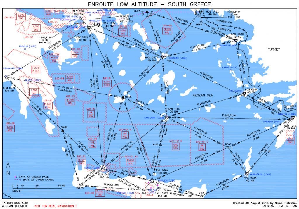
Probably for the first time in Falcon years (I have not seen any similar chart anywhere, at least as far as I know) created an Enroute Low Altitude chart, the specific one for South Greece.
With an Enroute chart you can do 2 things: First you can have REAL Air Navigation and second you can do great missions planning.
Below you can see a preview of the chart (must print it at A3 paper size - 42x29.7 cm or 16.54x11.69 inches):
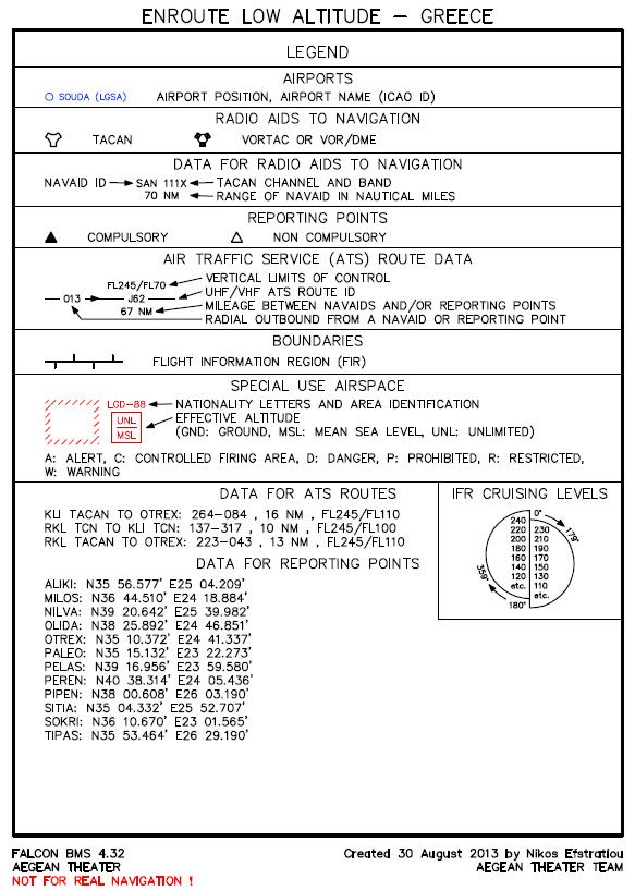
Also created a legend for this great chart, so here it is (print it at normal A4 paper size):
Gentlemen, as always in my works also this chart is under scale and this makes it extremely precise in order to can measure any distance or angle you want inside it with great accuracy. Maximum variation in distancies is 1 NM and in angles is 1 degree! Of course these variations are ONLY for distancies and angles out of the contained ones that are ALL PERFECT!
All the data as always are from real life, but the most airways are not real because in real life we use a lot of navaids that are not terminals (near an airport). So after a great study of the real Enroute Low Altitude chart, I tried to give as much more realism as also practical in order to can be done great air navigation inside south Aegean sea.
ALL the restricted areas are there with their real data and dimensions and in the proper place as also all the airports even those that they haven’t a NavAid.
Also I made a nice legend for those who are not familiar with similar charts. Except of the useful infos, contained the data for 2 ATS routes as also the GPS coordinates of the 4 Fixes.You can download it from the first post of this thread!
Next will follow for the North Greece, the North Turkey and the South Turkey in order to cover all the Aegean theater!
I hope to really enjoy it.
With my best regards,
Nikos Efstratiou. -
Well done and good job friend, must be try takeoff and lading with the new update
FalconID
-
Thanks bro!! navigation never will be the same after this chart!!!
Thank you very very much!!!
-
Excellent work Niko !
Many Thanks.
-
As always Nikos. Great work there mate… :bowd:
Greetings
-
Thank you Nikos!
-
Great work Nikos…
-
Outstanding as always thanks Nikos!
-
This post is deleted! -
Bravo Nikos, Bravo. Your chart is an absolute masterpiece and stroke of genius. I would love to have your airways integrated/superimposed into the BMS Aegean UI map. In that way, we could set out waypoints using real world navigation points.
-
Oh My My!!!
-
Bravo Nikos, Bravo. Your chart is an absolute masterpiece and stroke of genius. I would love to have your airways integrated/superimposed into the BMS Aegean UI map. In that way, we could set out waypoints using real world navigation points.
Hi there my good friend Gavin.
Thank you for your kindly words.
Well, wait to finish also and the other charts and then we can coordinate that.
Until then, just enjoy this innovating chart.
Nikos. -
Professional genius!
Thank you Nikos for your steady effort on realism for BMS. Most valueable.
I hope you take the time to sit back and have a beer sometimes, too!livrot
-
You never cease to amaze me, Nikos.


Cheers,
LS -
Thanks all of you Gentlemen.
It is very nice to see you so pleased. That encourage me to go ahead ;).
See you then at the Enroute chart for North Greece.
Nikos.


