Kneemap POH 0.7.0
-
O.k. let me show you a real photo in order to we clear this ;).
So here is a real Enroute Low Altitude chart from the U.S. :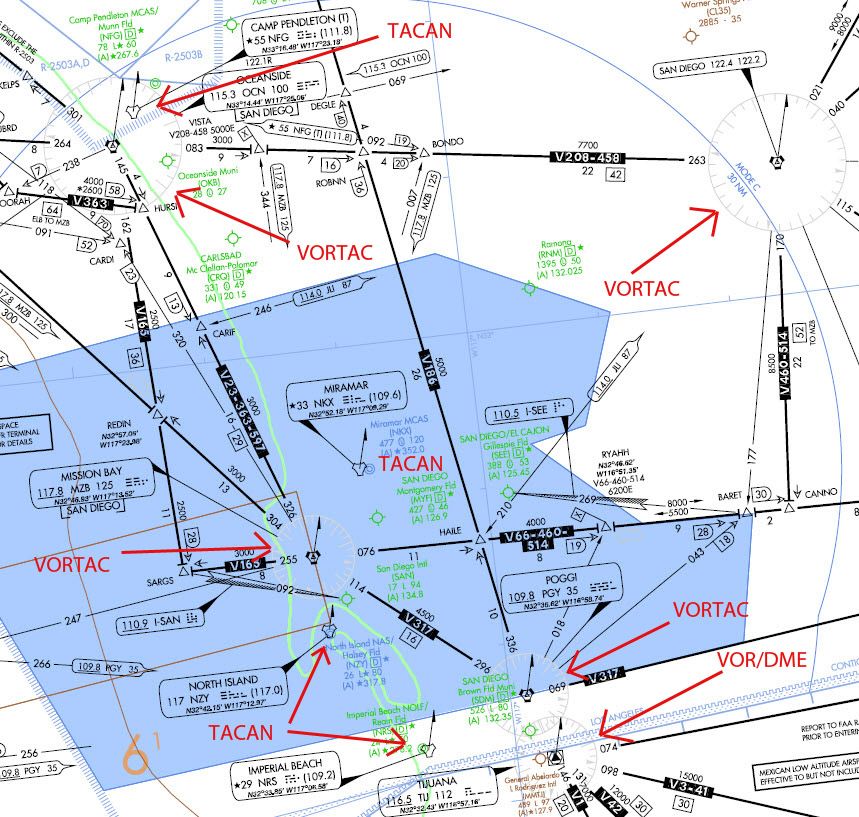
As you can see, i have marked with red some TACANs, VORTACs and a VOR/DME (look at the lower right of the photo).
You can see that all the VORTACs and the VOR/DME have the circle around them. But none of the TACANs have it!
In other words they aren’t correct the signs at the legend of the kneemap.
So at Legend, leave the sign of the VORTAC as it is, it is correct.
Then add the sign of the TACAN, as you see it in the photo. It is exactly the border of the VORTAC sign.
Last inside the map you must use the 2 specific signs (TACAN and VORTAC) at the locations that we have the NavAids. But you must also add the circle around the sign of the VORTAC, like in the photo. But ONLY around of the VORTACs, NOT around of TACANs!
I will provide you with a list in order to know exactly the kind of each one NavAid in order to represent it in the kneemap with the correct sign.
I hope now to be more clear…
See you buddy.
Nikos. -
I think I now understand what you meant to me … Sorry for my comprehension problems.
-
Haha, Joe my good friend with one sign:
 !
!
I like a lot your damn fast reactions as also your persist to realism!
We both like it (the realism) until to death…
Thanks partner.
So now the Legend is perfect. Don’t forget my remarks when you will start to put the signs inside the map. When you want to work on them give me a “call”. I must provide you a list with the kind of each one NavAid.
Nikos. -
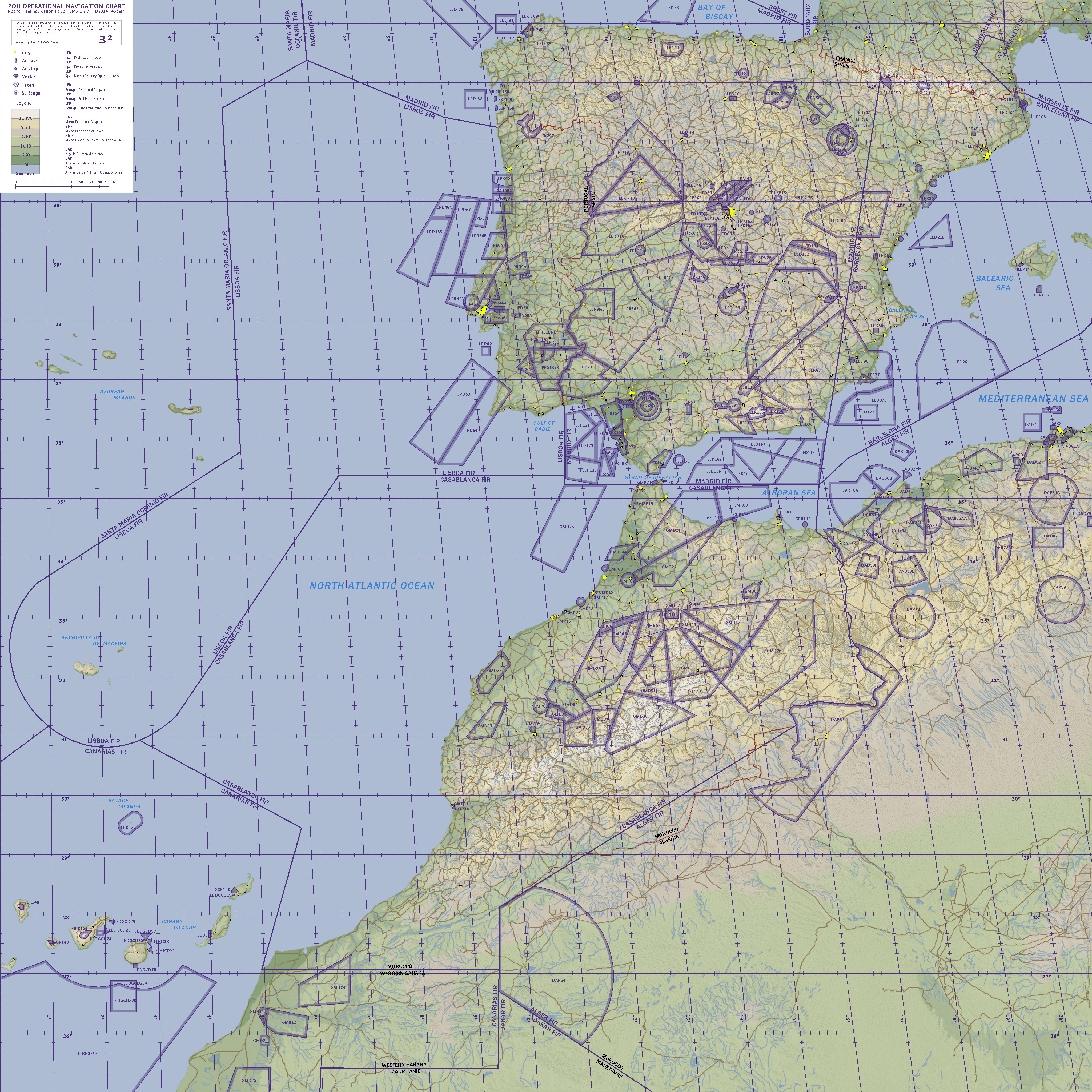
WIP, finished zones:
-
Hey looking good, one small request, could you add TRA54 and TRA55? I know they are temporary areas, but believe me they are here to stay (they have been around for the last 6 years at least lol), and are one of the most frequently used areas by the F16 here, sometimes for low level flight (it contains the Estrela mountain range) and even has it’s own refueling track. Here are the details:
LPTRA54
411800N 0072300W - 412248N0062333W - along portuguese/spanish border to 403157N 0064722W - 403200N 0074500W - 404350N 0074500W - 411800N 0072300W
FL 245 / GND H24 AIR EXERCISES, including AIR to AIR Refuelling OperationsLPTRA55
403200N 0074500W - 403157N0064722W - along portuguese/spanish border to 395337N 0065359W - 395400N 0074500W - 403200N 0074500W
FL 245 / 1500 FT AGL H24 AIR EXERCISES, including AIR to AIR Refuelling OperationsAlso I was thinking, have you checked with the ruler in the map if the headings are correct? Since the meridians are angled I’m concerned there could be some kind of error
-
also, those tiny triangles in the middle of those vor/vortacs, on the real Enroute Low Altitude chart, don’t worry about them. The clear triangles are non-compulsory ifr reporting points, the solid triangles are compulsory reporting points. You could just remove them entirely.
-
Hey looking good, one small request, could you add TRA54 and TRA55? I know they are temporary areas, but believe me they are here to stay (they have been around for the last 6 years at least lol), and are one of the most frequently used areas by the F16 here, sometimes for low level flight (it contains the Estrela mountain range) and even has it’s own refueling track. Here are the details:
LPTRA54
411800N 0072300W - 412248N0062333W - along portuguese/spanish border to 403157N 0064722W - 403200N 0074500W - 404350N 0074500W - 411800N 0072300W
FL 245 / GND H24 AIR EXERCISES, including AIR to AIR Refuelling OperationsLPTRA55
403200N 0074500W - 403157N0064722W - along portuguese/spanish border to 395337N 0065359W - 395400N 0074500W - 403200N 0074500W
FL 245 / 1500 FT AGL H24 AIR EXERCISES, including AIR to AIR Refuelling OperationsAlso I was thinking, have you checked with the ruler in the map if the headings are correct? Since the meridians are angled I’m concerned there could be some kind of error
Indeed, those are very important areas to have in the map.
Pina, could you make a better location image, say with all Portuguese territory for better locating them?
Thanks. -
Hey looking good, one small request, could you add TRA54 and TRA55? I know they are temporary areas, but believe me they are here to stay (they have been around for the last 6 years at least lol), and are one of the most frequently used areas by the F16 here, sometimes for low level flight (it contains the Estrela mountain range) and even has it’s own refueling track. Here are the details:
LPTRA54
411800N 0072300W - 412248N0062333W - along portuguese/spanish border to 403157N 0064722W - 403200N 0074500W - 404350N 0074500W - 411800N 0072300W
FL 245 / GND H24 AIR EXERCISES, including AIR to AIR Refuelling OperationsLPTRA55
403200N 0074500W - 403157N0064722W - along portuguese/spanish border to 395337N 0065359W - 395400N 0074500W - 403200N 0074500W
FL 245 / 1500 FT AGL H24 AIR EXERCISES, including AIR to AIR Refuelling OperationsThank you very much for the report. I’ve seen defined as temporary in the NR 5.2-10 of November 15, 2012 and dismissed. I see no problem with including these two areas.
Indeed, those are very important areas to have in the map.
Pina, could you make a better location image, say with all Portuguese territory for better locating them?
Thanks.These areas have well localized. They are not a problem.
@pina:Also I was thinking, have you checked with the ruler in the map if the headings are correct? Since the meridians are angled I’m concerned there could be some kind of error
Yes, everything is checked. This topic has been discussed many times. Use the outil Search forums, please.
Into BMS forums
https://www.benchmarksims.org/forum/showthread.php?18303-How-to-create-a-good-Kneemap/page2
https://www.benchmarksims.org/forum/showthread.php?18166-POH-0-7-0-GPS-Problem&highlight=gps+coordinates
https://www.benchmarksims.org/forum/showthread.php?15914-South-and-West-Coordinates-in-F16Into escuadron111 forums
http://www.escuadron111.com/new/index.php?/topic/11471-coordenadas-ew-en-bms/
http://www.escuadron111.com/new/index.php?/topic/12167-voluntario-edici%C3%B3n-kneemap-poh-070/And the answer is: are adapting to the limitations of Falcon.
Do you know that can not manage Falcon BMS negative latitudes for now? You can not enter negative latitudes in the DED.
Do you know the Prime Meridian passes through our Theater (latitude 0)? Korea, Balkans, Aegean, Sinai is located to the left of the Prime Meridian. Look, please, at latitudes of POH. The prime meridian (0 °) has been moved to the end of our Weast Theatre. to enter GPS coordinates in the DED.
Although it could introduce negative latitudes (which can not). Actually: Do you think, in the Theater of Korea GPS coordinates and lines that are not in the same position as the real world are used know? (And the same in all theaters of Falcon)
Do you know that the projection of the world of Falcon has special characteristics? What Falcon’s world, when we fly, is flat?
What Falcon two tacan, radio frequencies … can not have near the same frequency if operating problems do not occur?
For example:
In Falcon BMS 4.32. Theater Korea
INTL RKSS Kimpo airport
South Korea
N 37 ° 36,868 ‘- E 127 ° 42,801’
*In the real world:
Kimpo Airport
Coordinates
37 ° 33’29? N 126 ° 47’26? EAnother example
In Falcon BMS. Theater EMF:
Kalamata Airport
Coordinates Falcon:
N 37 ° 03 580 / E 23 ° 03,355Real world coordinates
Coordinates 37 ° 04’06 .18? N22 ° 01’32 .29? EUsing real GPS positions inaccuracy of up to 100 km occur, depending on the area map. The maps of the real world does not match 100% with the coordinates. The Navaids real world do not apply.
But if you use our kneemap, GPS Falcon, the POH Navaids and our future maps will have no problems.
*Maybe with FSX or perhaps with Orbiter Space Simulator (put other examples) …. But not with Falcon BMS. Let us accept this.
also, those tiny triangles in the middle of those vor/vortacs, on the real Enroute Low Altitude chart, don’t worry about them. The clear triangles are non-compulsory ifr reporting points, the solid triangles are compulsory reporting points. You could just remove them entirely.
I do not understand your approach. I use a translator.
The translator gives me an incomprehensible text. You could put it in other words? Thanks. -
also, those tiny triangles in the middle of those vor/vortacs, on the real Enroute Low Altitude chart, don’t worry about them. The clear triangles are non-compulsory ifr reporting points, the solid triangles are compulsory reporting points. You could just remove them entirely.
Well most of the VORTACs and VOR/DMEs are compulsory reporting points, so Joe is good to have the small black triangle inside the VORTAC sign ;).
Of course if he wants, he can made it solid, means the small black triangle.
Nikos. -
Hello Joe, yes I was aware of those limitations, but I wasn’t asking about the coordinates, but about the headings. I was asking if the 360 true heading was always aligned with the meridian lines. Because at least in Korea, with the meridians always being 90º with the parallels, inherently there would be no problem, what I was concerned was if in POH the north was pointing east of the meridian, since it is skewed west at some points.
-
Amazing work guys!
Thanks you very much!
")
-
Hello Joe, yes I was aware of those limitations, but I wasn’t asking about the coordinates, but about the headings. I was asking if the 360 true heading was always aligned with the meridian lines. Because at least in Korea, with the meridians always being 90º with the parallels, inherently there would be no problem, what I was concerned was if in POH the north was pointing east of the meridian, since it is skewed west at some points.
You mean in Korea Theatre meridians are perfectly aligned with the north and south?
I can understand if a mission in Korea with a route along a meridian from north to south (east of the theater, where there is more distortion) … When entering your cab, the airplane’s nose will point to the South?
Try it, please.
-
Hello, just did, turns out I was under the false impression that Korea didn’t have the distortion, but I checked and it does. Kadena is 7º east of the meridian. Seems like another of Falcon’s quirks. Does Falcon support magnetic declination? If it does it could be used to mitigate the distortion, otherwise I guess we’ll just have to live with it.
-
Resignation, we since December 1998 we are living with it.
-
All falcon terrain suffer from it, there’s no way around it and that’s the exact reason why we can’t use real maps and why we need to spend so much time creating our own charts
Korea and EMF and all other terrain have that issueYou can use the TACAN symbol for TACAN stations and the VORTAC symbol for VORTAC and VOR/DME stations.
there is zero difference between vortacs and tacans in falcon
the code support only tacans - personnaly i consider a bms tacan anything from tacan to vortacs to vordmes
the reason i called some stations vortacs is to differenciate them from airbase collocated tacans which are the only navaids possible up to 4.32
past 4.32 we’ll have non collocated navaids possible and i decided to call those vortacs, that’s why i made the difference for them in my korea and emf and ito work.
therefore, the difference betweeen a vortac and a tacan - in falcon - is purely semanticWhat Falcon two tacan, radio frequencies … can not have near the same frequency if operating problems do not occur?
I think i have just found a way to circumvent that one
I will follow the criteria of RedDog in the map EMF
I’m glad you think like that Joe, it will give a nice sense of unity and i’m proud to have my work serving as example for other’s terrain.
if you have questions, don’t hesitate
Very well done, very good job and believe me i know how time consuming this is !! -
@Red:
therefore, the difference betweeen a vortac and a tacan - in falcon - is purely semantic
I understand perfectly. Thanks
@Red:
I think i have just found a way to circumvent that one ;)!
I would be very interested to hear your theory
@Red:
I’m glad you think like that Joe, it will give a nice sense of unity and i’m proud to have my work serving as example for other’s terrain.
if you have questions, don’t hesitate
Very well done, very good job and believe me i know how time consuming this is !!Now, I really appreciate your work.
All users of Falcon give thanks for their work, obviously. But not all appreciate the incredible effort involved in creating these maps. I include myself ….
… Until, recently …Now, I’ve started editing the Kneemap, I have not been aware of the enormous workload, details, coordination capacity necessary knowledges, etc… that are necessary to deal with this task solvency …
And of course: time.I am aware of my limitations (including my lack of English) and that we must learn from those who have more knowledge. Unify criteria is important too. And with enthusiasm and excitement I am pleased with the result. His words pleased me. Thank you for your excellent work. And also for the help they gave us years ago (about 2002, wow, as the years pass) for making our first file stations.dat. 0.4.0 for POH
Take his offer. Yes, I have three questions.
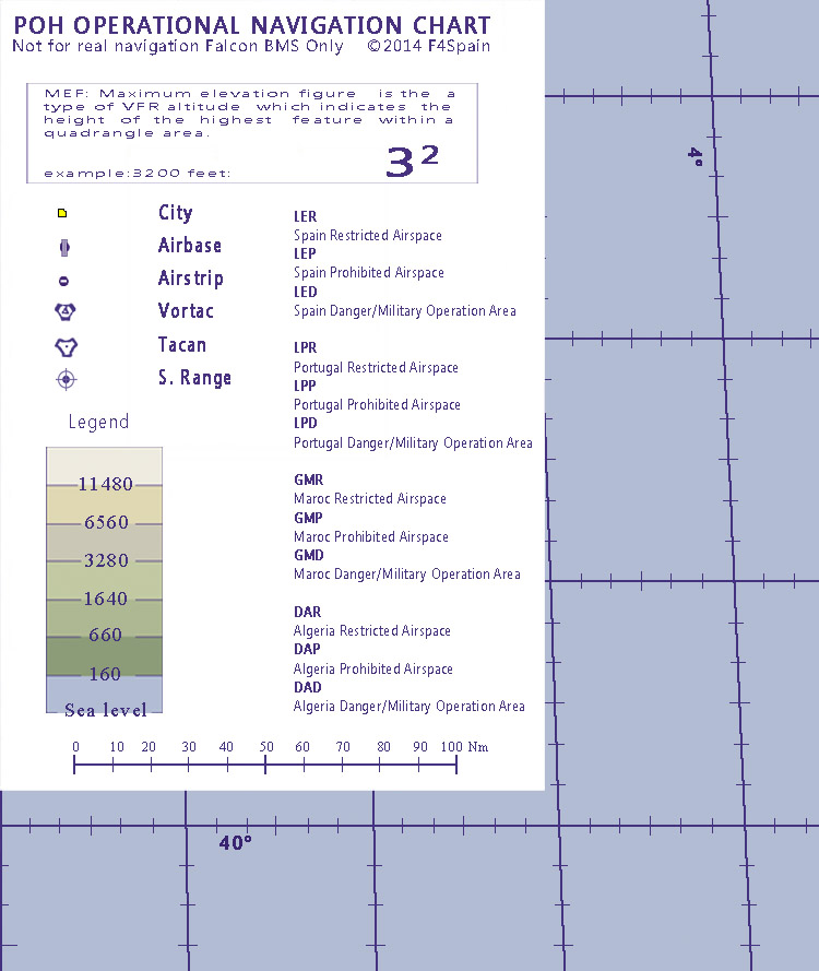
What is the resolution of the original map work?
How do get the roads and rivers so thin?
How to see the MEF data into map. How obtain the numbers?Again, thank you.
-
@Joe:
How to see the MEF data into map. How obtain the numbers?
This should be a good starting point, I have a paper VFR chart of 2013 and there are some discrepancies, but nothing to owrry about too much.
http://skyvector.com/?ll=38.92950240970293,-8.530334461931847&chart=301&zoom=5I think those numbers aren’t MEF but actually are MORA (Minimum Off Route Altitude), difference being MEF is the maximum elevation of terrain/obstacle, while MORA is MEF+1000 feet, or MEF+2000 feet above mountainous regions. I will try to check today with my instructors.
Not sure how the editors work, but isn’t there some option to show the highest elevation of an area or something like that?
-
Joe,
What is the resolution of the original map work?
depends on theather type. 64 theaters have 2048 maps
128 theathers have 4096 mapsRecently i have upscaled the korea maps (64 theaters) from 2048 to 4096
but this was only possible with code support. of course, the hardest thing is still to find the possibility to create a decent map in those resolutionHow do get the roads and rivers so thin?
I tend to have them in a separate layer that i can manage on it’s own.
they get fine if you don’t blow your native image. if your theater is 64bits and your original map 2048 and you blow it up to 4096 then your roads and rivers will be a mess, it will be very visible
the trick is to create an original image in your end result resolution
i always create multiple images in the beginning, one for background, one for roads, one for rivers for instanceHow to see the MEF data into map. How obtain the numbers?
64 bits terrain, i have a tool to do it
128 bit terrain, unfortunately that tool doesn’t work, then i do it manually with terrain editor from monster. I color the tile elevation number in different colours and unzoom to the max factor, then i have elevation according to latitude and longitude
painstaking and tedious and time consuming work
that’s how i did emf and ods and i am not looking forward to do that again")
i whish that small tool would work for 128 bit terrain, but it does not.
-
@Red:
there is zero difference between vortacs and tacans in falcon
the code support only tacans - personnaly i consider a bms tacan anything from tacan to vortacs to vordmes
the reason i called some stations vortacs is to differenciate them from airbase collocated tacans which are the only navaids possible up to 4.32
past 4.32 we’ll have non collocated navaids possible and i decided to call those vortacs, that’s why i made the difference for them in my korea and emf and ito work.
therefore, the difference betweeen a vortac and a tacan - in falcon - is purely semanticAll the previous are correct and i also know them.
I just suggest to Joe to use in POH kneemap both TACAN and VORTAC signs as a nice reference to the kind of them from real world.
It needed no more time ;).
Nikos. -
All the previous are correct and i also know them.
I just suggest to Joe to use in POH kneemap both TACAN and VORTAC signs as a nice reference to the kind of them from real world.
It needed no more time ;).
Nikos.Indeed. Like RedDog we will make this differentiation between TACAN and VORTAC our Kneemap (although for the purposes of Falcon BMS are the same thing) in the search for more immersion and realism.
