Instrument landing system localizer off?
-
not legally.
") but for a non precision approach……
but for a non precision approach……for a non precision approach, you do not fly a glideslope. In a non precision approach, you step down in blocks as you get closer to the field. So you might know that after DME 20, you can safely descend to 3000 ft AMSL, and that after DME 10 you can descend to 1500 ft AMSL, and 700 feet after DME 5…
You cannot fly a constant slope though, you descend to the new block then wait for the next distance you can descend at. You have this stuff already in your approach charts, which are included in your BMS install folder…
-
But at DME 6 no more step, you have to fly a glideslope.
Also remember that the same thing that draws the diamond on the HUD is the same thing that puts your bombs on target. SPI stuff I think. Check out landing video with stpt on the runway. It looks possible imo.
-
No matter how you turn it, IRL, this kind of approach is inherently flawed for several reason.
- GPS precision is not optimal. Error is inside 10m most of the time, but 10m can be a lot on a runway threshold.
- GPS is not perfect : you can have interferences on the signal, not be able to see enough satellites, etc…
- without a regular GPS fix, INS can drift. Usual figure is 1 NM per hour, so 100 ft per minute. Again, on a runway threshold, thats a lot…
And most importantly, an ILS slope & course will be verified by ground crews, so its reliability is fairly certain. But you have absolutely no way to realize your GPS/INS data is faulty before actually seeing the runway.
In F4, these imprefections are not modeled (yet ?). Whether in AF or BMS.
So this kind of approach might be useful in an EMERGENCY, but it cannot be a regular RL procedure. Just as its perfectly normal that it does work in F4, as all these errors are not modeled.
With that in mind, do what you want for your approaches.
-
for a non precision approach, you do not fly a glideslope…
What about VASI or PAPI(?). That does slideslope is that an example of an non precision approach?
-
The mark stpt is placed on the end of the runway. You can’t see the runway but you can see the mark stpt.
Knowing this all you have to do is place the diamond on the pitch ladder. Put on 2.5 or 3* you got glideslope.I don’t know if he used the HSI. I’ve done it with and without HSI on impossible xwind te/
I understand how it’s done. The question is whether a markpoint is providing any radio-navigation information. It is not. It’s just a reference mark to assist finding a spot on the ground. You can use that in many ways.
TACAN/ILS on the other hand DO provide direct radio-navigation guidance including direction, distance, heading and glide path. They send that information to you. A mark point does not.
-
VASI and PAPI are VFR indicators. If you can see those, you are visual and can transition to heads up flying.
If you get to DME 6, and you do not have an ILS intercept, then you cannot fly a psuedo approach - at least, not whilst keeping your SQ/CC happy about you following the regs.
-
I understand how it’s done. The question is whether a markpoint is providing any radio-navigation information. It is not. It’s just a reference mark to assist finding a spot on the ground. You can use that in many ways.
TACAN/ILS on the other hand DO provide direct radio-navigation guidance including direction, distance, heading and glide path. They send that information to you. A mark point does not.
FWIW,
HSI in NAV mode(EGI/INS/GPS) does everything that TCN(radio beacons) mode does. Two big differences, NAV mode works in RF silence. TCN DME does not.
NAV mode is not limited to beacon radio range..
-
three big differences.
TCN is approved for use for RNAV and TCN approaches. EGI on the other hand, is not approved for RNAV or GPS approaches.
You keep ignoring the point caper - its not about how it works, its about a boring piece of paper that says you are not allowed to do it.
PSST: If you wanna do it in falcon, I won’t tell anyone and word shouldnt get back to your CO.
-
Read my previous post, this is why IRL, TACAN & ILS are considered reliable and thus legal, and why INS & GPS method are neither :
No matter how you turn it, IRL, this kind of approach is inherently flawed for several reason.
[…]In F4, the limitations of GPS and INS disappear, thats why it works. Even though, I prefer to fly by the RL procedures. Now have it your way.
-
for a non precision approach, you do not fly a glideslope. In a non precision approach, you step down in blocks as you get closer to the field. So you might know that after DME 20, you can safely descend to 3000 ft AMSL, and that after DME 10 you can descend to 1500 ft AMSL, and 700 feet after DME 5…
You cannot fly a constant slope though, you descend to the new block then wait for the next distance you can descend at. You have this stuff already in your approach charts, which are included in your BMS install folder…
Hi there mate.
Well it seemed that you have a small confusion.
First in a non precision approach you can fly a slope! We maybe don’t call it “GlideSlope” in order (i guess) to not been confused with the Slope of ILS approach, but you can fly a slope. Just like the below example.
Also in a non precision approach you CAN have a constant slope (descending), and not only at TACAN or VORTAC or VOR/DME approaches but and at RNAV/GPS approaches.
Take a look at the below official chart (RNAV/GPS) for RWY 26 of Langley AFB.
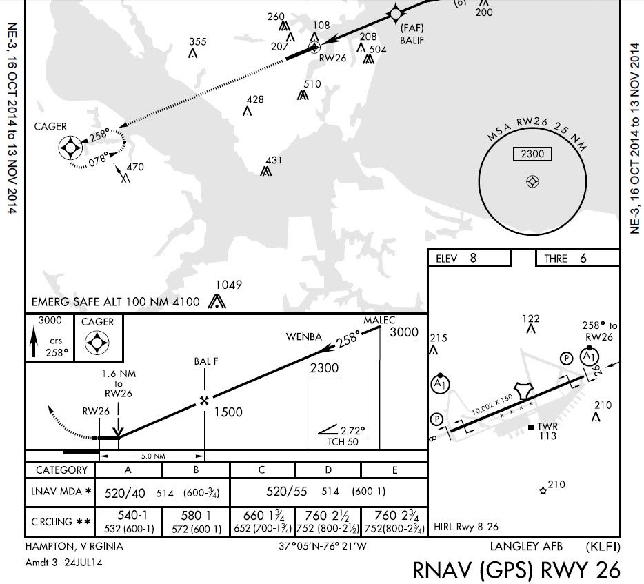
Take a good look at the VDA that is 2.72 deg. You can also make the check calculations to verify that from FAF (BALIF) until and THR of RWY 26 the descent has a constant slope of 288 FT/NM or 2.72 deg.
It is just a matter of the conditions if a department create the procedure with a constant slope or not, and NOT that this never applied.")
Nikos. -
The difference between precision approach and non-precision approach is if the radio navigation aid gives vertical guidance information. This has nothing to do with the actual path you fly. You can fly a VOR approach perfectly smooth in glide angle as long as you comply with the altitude restrictions at each fix and it’s technically legal to fly a staircase descent inside the ILS GS as long as you stay inside 50% needle deflection.
As for flying with whatever sensor you want. This is not how it works in reality. It doesn’t matter if your system is good enough or if your mommy thinks you are handsome or if it works. When ATC says you are cleared to fly a published approach by name, they mean that approach EXACTLY as written. No substitutions allowed at all. Being creative gets you no friends. Imagine if a cop pulls you over and you hand him a driver’s license that you made yourself at home. It’s not going to go over well no matter how good your penmanship
-
TCN is approved for use for RNAV and TCN approaches. .
TCN will get you to the glideslope. What visibility do you need for a TACAN approach…5nm? I seen the beacon in middle of corn fields no where near the runway.
ILS is 1/4nm visibility me thinks. -
But at DME 6 no more step, you have to fly a glideslope.
you have to fly a computed vertical speed in relation to your GS until minimums or MAPT.
Caper … stop BS please … you really do know nothing about the subject.

Even you description about the markpoint tip is wrong! (to work, you have to put the markpoint on runway entry, not at the end!)
-
you have to fly a computed vertical speed in relation to your GS until minimums or MAPT.
Caper … stop BS please … you really do know nothing about the subject.
Even you description about the markpoint tip is wrong! (to work, you have to put the markpoint on runway entry, not at the end!)
So, you fly the VVI? That half of it. How do you know you’re heading into the tower?
DJ you need to chill and use some intuition. -
So, you fly the VVI? That half of it. How do you know you’re heading into the tower?.
… You do not really know, and this is why it is called non precision approach.
Caper, you are certainly a brillant engineer (?) I am not, and I will never try to teach you your RL job.
But there, we are plenty on mine … So I will try to find some docs to enhance your knowledges about IFR and instrument procedures, because you are totaly confused and seems to have absoluetly no idea about what it is actually, and how to proceed.
…
ASUSTeK ROG MAXIMUS X HERO / Intel Core i5-8600K (4.6 GHz) / NVIDIA GeForce RTX 3080 Ti FE 12GB / 32GB DDR4 Ballistix Elite 3200 MHz / Samsung SSD 970 EVO Plus 2TB / Be Quiet! Straight Power 11 1000W Platinum / Windows 10 Home 64-bit / HOTAS Cougar FSSB R1 (Warthog grip) / SIMPED / MFD Cougar / ViperGear ICP / SimShaker JetPad / Track IR 5 / Curved LED 27'' Monitor 1080p Samsung C27F396 / HP Reverb G2 VR Headset.
-
Your jumped into this page, I don’t if you are talking about mark pt, TCN, lLS and giving me shit.
Im not a engineer but I have dealt with enough of them. I’m a toolmaker, video/audio tech, Desktop and MPU programmer, for an Army contract I was a UAV testbed safety pilot, to payroll I paid as a lab tech. -
Legally you can descend immediately after the FAF to the MDA on a non-precision approach and fly level at MDA all the way to the VDP or MAP. There should be 250’ (75m) of obstacle clearance that whole way. Of course it is smart and advisable to make a calculated (and timed) descent smoothly from the FAF to the VDP. The way you do this is knowing what vertical speed matches your desired flight path angle and ground speed. This is doubly a good idea with ILS because it GS signal can have false lobes that are wrong (but show on GS indication). The only way to know is to discover descent rate (and thus angle) isn’t as expected. I think HUD or other indication of FPA is just fine for judging decent after FAF for non-precision approach. All that matters is not busting MDA and going missed the correct time after.
I don’t think caper is as wrong as you say. You have to fly a glideslope (not necessarily electronic) of some kind, he didn’t say how. And “end” could mean near end or far end. Runway has two ends. MDA/DH heights are quite variable. Cat I ILS is common 200’ ~1/3SM (RVR or airborne visibility?). Non-precision is more, 300-1000’ MDH 1+ SM.
-
I’m a toolmaker, video/audio tech,
Does’t change the fact that you are a specialist on your area.
-
I don’t think caper is as wrong as you say.
Yep, I see what you mean … But I doubt that our friends will understand the same and might easily goes into wrong assumption/conclusion.
-
Regarding some comments concerning the events of flight Norman 75
(Lt. Col. Dan “Two Dogs” Hampton) I have to say:I recommend to whoever is able to read / re-read the story as outlined
by the prolog and chapter 8 (which is actually the continuation of the prolog)
in his book. I’m certain that after a careful analysis of the events that led
to the landing at that airbase the remarks of “Bad flight management” and choices made not according
to what a “Good Pilot” will do won’t seem to fit here.
I agree with the “Trapped” notion but not with the part of “bad or miss evaluation” which I don’t see
as applicable to the events.The landing procedure as outlined in the story:
Regarding the airbase of landing Ali Al-Salem in Kuwait from what I found
it is likely that the air base was equipped with ILS (and maybe VORTAC).
This is based on 2 things:- From an internet search found in World Aero Data (and other sources too) for the airbase
that the runway used for landing (30L) has ILS and the airbase has VORTAC. - In the story he clearly refers to ILS and ILS bars.
The procedure itself in a skimmed form (please note that the airbase had no published procedures):
- First pass by “Two Dogs” only: Flying to airbase, contacting tower, electing runway to land, arranging for
runway lightings (+ approach lights), taking a mark point (set at ~1000ft from threshold) for approach and (implied) ILS intercept
(+ distance (DME) info. if we rule out VORTAC existence/usability by then). - “Two Dogs” passes details to other 9 flight members (including the mark point info.) and sequences the flight to landing.
- 2nd pass (with other fight members following): leading the way and verifying the approach , ILS intercept + guidance and conditions (runway vis.).
Informs other flight members (runway vis. 1 mile at 300ft) and himself executes a missed approach (others land) in order to be for a help if a flight member gets into a trouble. - “Two Dogs” commences a landing with deteriorating conditions (+ possible LG emergency: only 2 LG green lights) that compel him to violate the 200ft alt. minimum.
He eventually acquires vis. on the runway and lands.
I hope this clarifies the subject.
As for his discharge from the air force: Not true.
He was grounded by his OG for violating a 10000ft deck
during a combat mission. The violation occurred earlier the same day of the above mentioned landing
event and was necessary (mainly due to weather) for an emergency CAS response by him.
He heard of his grounding 2 days after his return to his home base from the divert.
His SQ/CC upon hearing of his grounding was “positively apoplectic (= angered, as someone having a stroke)”.
This also reached to some top command who were not only positive of his conduct but also gave some
negative attention to the OG. Of course they canceled the grounding the very same day. He also was praised in a letter sent to the OG from a
commander of the ground unit he helped. - From an internet search found in World Aero Data (and other sources too) for the airbase
