Kneemap POH 0.7.0
-
Hello, just did, turns out I was under the false impression that Korea didn’t have the distortion, but I checked and it does. Kadena is 7º east of the meridian. Seems like another of Falcon’s quirks. Does Falcon support magnetic declination? If it does it could be used to mitigate the distortion, otherwise I guess we’ll just have to live with it.
-
Resignation, we since December 1998 we are living with it.
-
All falcon terrain suffer from it, there’s no way around it and that’s the exact reason why we can’t use real maps and why we need to spend so much time creating our own charts
Korea and EMF and all other terrain have that issueYou can use the TACAN symbol for TACAN stations and the VORTAC symbol for VORTAC and VOR/DME stations.
there is zero difference between vortacs and tacans in falcon
the code support only tacans - personnaly i consider a bms tacan anything from tacan to vortacs to vordmes
the reason i called some stations vortacs is to differenciate them from airbase collocated tacans which are the only navaids possible up to 4.32
past 4.32 we’ll have non collocated navaids possible and i decided to call those vortacs, that’s why i made the difference for them in my korea and emf and ito work.
therefore, the difference betweeen a vortac and a tacan - in falcon - is purely semanticWhat Falcon two tacan, radio frequencies … can not have near the same frequency if operating problems do not occur?
I think i have just found a way to circumvent that one
")
I will follow the criteria of RedDog in the map EMF
I’m glad you think like that Joe, it will give a nice sense of unity and i’m proud to have my work serving as example for other’s terrain.
if you have questions, don’t hesitate
Very well done, very good job and believe me i know how time consuming this is !! -
@Red:
therefore, the difference betweeen a vortac and a tacan - in falcon - is purely semantic
I understand perfectly. Thanks
@Red:
I think i have just found a way to circumvent that one ;)!
I would be very interested to hear your theory
@Red:
I’m glad you think like that Joe, it will give a nice sense of unity and i’m proud to have my work serving as example for other’s terrain.
if you have questions, don’t hesitate
Very well done, very good job and believe me i know how time consuming this is !!Now, I really appreciate your work.
All users of Falcon give thanks for their work, obviously. But not all appreciate the incredible effort involved in creating these maps. I include myself ….
… Until, recently …Now, I’ve started editing the Kneemap, I have not been aware of the enormous workload, details, coordination capacity necessary knowledges, etc… that are necessary to deal with this task solvency …
And of course: time.I am aware of my limitations (including my lack of English) and that we must learn from those who have more knowledge. Unify criteria is important too. And with enthusiasm and excitement I am pleased with the result. His words pleased me. Thank you for your excellent work. And also for the help they gave us years ago (about 2002, wow, as the years pass) for making our first file stations.dat. 0.4.0 for POH
Take his offer. Yes, I have three questions.
What is the resolution of the original map work?
How do get the roads and rivers so thin?
How to see the MEF data into map. How obtain the numbers?Again, thank you.
-
@Joe:
How to see the MEF data into map. How obtain the numbers?
This should be a good starting point, I have a paper VFR chart of 2013 and there are some discrepancies, but nothing to owrry about too much.
http://skyvector.com/?ll=38.92950240970293,-8.530334461931847&chart=301&zoom=5I think those numbers aren’t MEF but actually are MORA (Minimum Off Route Altitude), difference being MEF is the maximum elevation of terrain/obstacle, while MORA is MEF+1000 feet, or MEF+2000 feet above mountainous regions. I will try to check today with my instructors.
Not sure how the editors work, but isn’t there some option to show the highest elevation of an area or something like that?
-
Joe,
What is the resolution of the original map work?
depends on theather type. 64 theaters have 2048 maps
128 theathers have 4096 mapsRecently i have upscaled the korea maps (64 theaters) from 2048 to 4096
but this was only possible with code support. of course, the hardest thing is still to find the possibility to create a decent map in those resolutionHow do get the roads and rivers so thin?
I tend to have them in a separate layer that i can manage on it’s own.
they get fine if you don’t blow your native image. if your theater is 64bits and your original map 2048 and you blow it up to 4096 then your roads and rivers will be a mess, it will be very visible
the trick is to create an original image in your end result resolution
i always create multiple images in the beginning, one for background, one for roads, one for rivers for instanceHow to see the MEF data into map. How obtain the numbers?
64 bits terrain, i have a tool to do it
128 bit terrain, unfortunately that tool doesn’t work, then i do it manually with terrain editor from monster. I color the tile elevation number in different colours and unzoom to the max factor, then i have elevation according to latitude and longitude
painstaking and tedious and time consuming work
that’s how i did emf and ods and i am not looking forward to do that again")
i whish that small tool would work for 128 bit terrain, but it does not.
-
@Red:
there is zero difference between vortacs and tacans in falcon
the code support only tacans - personnaly i consider a bms tacan anything from tacan to vortacs to vordmes
the reason i called some stations vortacs is to differenciate them from airbase collocated tacans which are the only navaids possible up to 4.32
past 4.32 we’ll have non collocated navaids possible and i decided to call those vortacs, that’s why i made the difference for them in my korea and emf and ito work.
therefore, the difference betweeen a vortac and a tacan - in falcon - is purely semanticAll the previous are correct and i also know them.
I just suggest to Joe to use in POH kneemap both TACAN and VORTAC signs as a nice reference to the kind of them from real world.
It needed no more time ;).
Nikos. -
All the previous are correct and i also know them.
I just suggest to Joe to use in POH kneemap both TACAN and VORTAC signs as a nice reference to the kind of them from real world.
It needed no more time ;).
Nikos.Indeed. Like RedDog we will make this differentiation between TACAN and VORTAC our Kneemap (although for the purposes of Falcon BMS are the same thing) in the search for more immersion and realism.
-
First airbases WIP for evaluation line of work.
Gibraltar, Jerez and Rota. Open the image in another window for full size.

-
As I can find the position of the TACAN station with respect to the airbase?
-
@Joe:
As I can find the position of the TACAN station with respect to the airbase?
Joe my friend, GREAT work there. Bravo!

Now one remark: If you want use an other one color for the sign of TACAN (and of course VORTAC) and for the data of NavAids/UHF-VHF/ILS in order to can be easily readed.
In order to can see the exact location of the TACAN station of each one airport, simply when you create a T.E. mission from an airport, then just take a look at the position of the STPT 1 (steerpoint 1) when you are inside cockpit. It is always the exact position of the TACAN station for all airports (not airstrips!).
I hope to help ;).
Nikos. -
Hello Joe, this is how it looks like in Jeppesen’s VFR sectionals.
187 is elevation in feet, 2459m is longest runway length. TWR is tower frequency. They only publish the VHF one here, but I think if you did like: TWR 118.100 249.0 it would be clear enough which one’s which. Also I think the ILS frequency isn’t needed here, it’s cluttering the chart and you really shouldn’t be looking for it there anyway, but rather in the approach chart.
-
Hey Joe,
This looks very nice. Great work mate.
-
I’m still doing tests. The purpose is that the data reading clearer.
TACAN and VORTAC icon thinner. See legend
Looking example of Gibraltar
Normal text (no bold)
Text and icons in black.
Text with white borderPlease reviews. Thank you.
Open image in another windows to full size
-
Nice Joe. I like it and find it good readable.
Now my remark is to replace the word “Tower:” with this one “TWR:” in order to gain some space especially at places that we have a lot of airports near.
Also at airports that we have both UHF and VHF frequencies and you have no room to add both of them, prefer to add the UHF one.
Thank you once again for your efforts!
By the way the fix is right for me. That means that you already released my hands and i can be on works again :p.
Nikos.PS. At the Legend, replace the words “Vortac” and “Tacan” with capitals, means with “VORTAC” and “TACAN” ;).
-
Not sure about the white cloud behind it. Have you tried white with purple stroke? Or the reverse, purple with white contour. It doesn’t need to be to wide, just 1 or 2 pixels of stroke wide, just enough to separate it from the background. Also, design student tip, avoid pure colors, try washed off shades of colors, they aren’t so aggressive on the sight. Besides that, all of the above said by ney
-
Hello Joe, this is how it looks like in Jeppesen’s VFR sectionals.
187 is elevation in feet, 2459m is longest runway length. TWR is tower frequency. They only publish the VHF one here, but I think if you did like: TWR 118.100 249.0 it would be clear enough which one’s which. Also I think the ILS frequency isn’t needed here, it’s cluttering the chart and you really shouldn’t be looking for it there anyway, but rather in the approach chart.
Agree.
Basically I would say just do the same as real ONC charts… nothing more nothing less
Anyway, good work!ASUSTeK ROG MAXIMUS X HERO / Intel Core i5-8600K (4.6 GHz) / NVIDIA GeForce RTX 3080 Ti FE 12GB / 32GB DDR4 Ballistix Elite 3200 MHz / Samsung SSD 970 EVO Plus 2TB / Be Quiet! Straight Power 11 1000W Platinum / Windows 10 Home 64-bit / HOTAS Cougar FSSB R1 (Warthog grip) / SIMPED / MFD Cougar / ViperGear ICP / SimShaker JetPad / Track IR 5 / Curved LED 27'' Monitor 1080p Samsung C27F396 / HP Reverb G2 VR Headset.
-
The lines of zones: is purple
I will use dark blue for airports (such as ONC Charts) … so it is less aggressive than pure black and differs as another color.
Softened white shading.
Change uppercase text.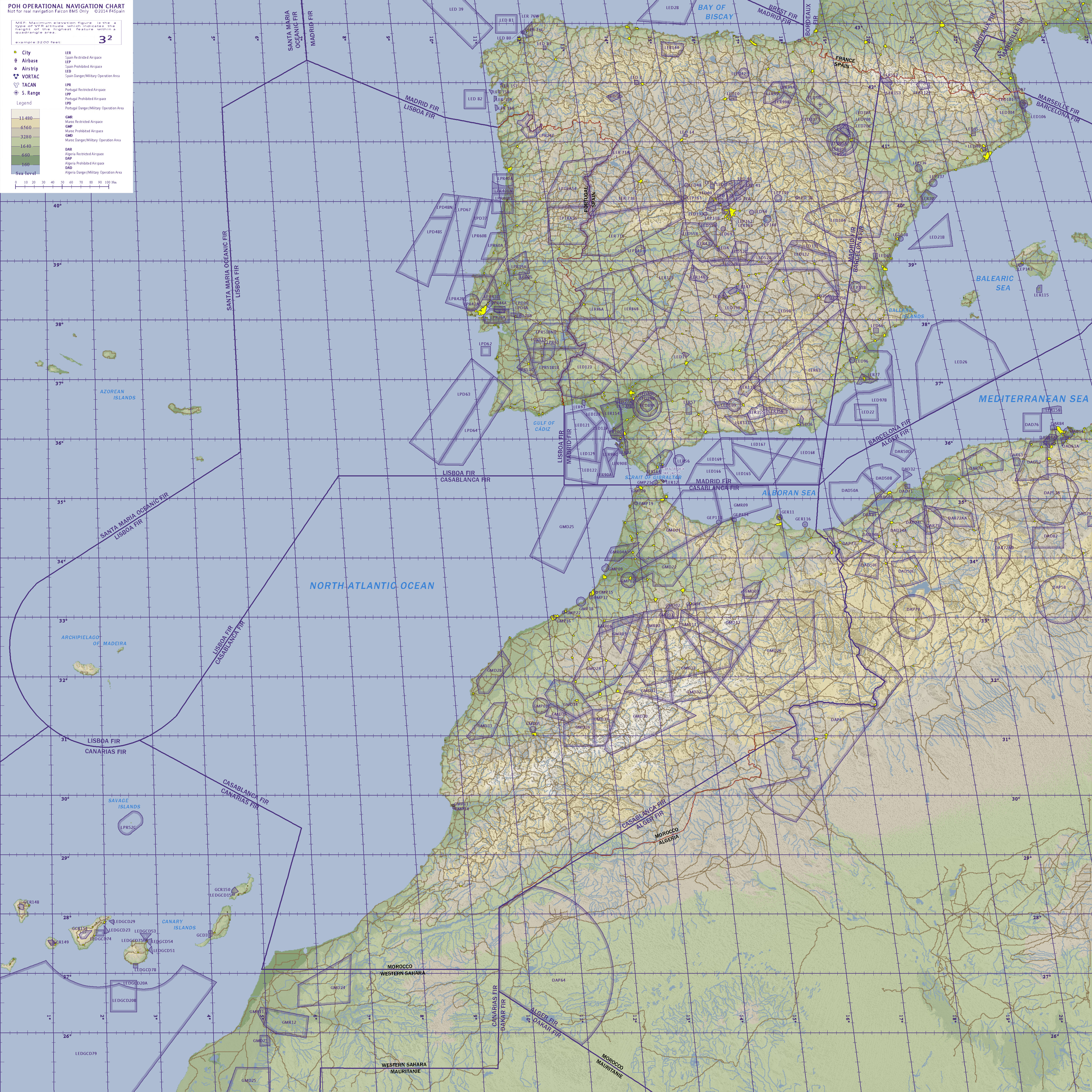
-
Nice Joe. I like it and find it good readable.
Now my remark is to replace the word “Tower:” with this one “TWR:” in order to gain some space especially at places that we have a lot of airports near.
Also at airports that we have both UHF and VHF frequencies and you have no room to add both of them, prefer to add the UHF one.
Thank you once again for your efforts!
By the way the fix is right for me. That means that you already released my hands and i can be on works again :p.
Nikos.PS. At the Legend, replace the words “Vortac” and “Tacan” with capitals, means with “VORTAC” and “TACAN” ;).
You have a PM…
-
