AG radar in BMS
-
Terrain masking isnt ? I need to check, but I would have thought so…
of course there is terrain masking on radar… coded in 4.32
-
Just went on youtube. Saw there is an advance AESA ( active electronically scanned array) already operational in f-16. This can do a2a and A2G target tracking simultaneously.
Just comparing what you highlight missing the video clips I saw
*No terrain masking
*No aperture radar
Hoping we could any close to the AESA in F4, or the guys in ED will do it.We won’t do ant AESA radar as we do not have any documentation to implement it correctly.
ASUSTeK ROG MAXIMUS X HERO / Intel Core i5-8600K (4.6 GHz) / NVIDIA GeForce RTX 3080 Ti FE 12GB / 32GB DDR4 Ballistix Elite 3200 MHz / Samsung SSD 970 EVO Plus 2TB / Be Quiet! Straight Power 11 1000W Platinum / Windows 10 Home 64-bit / HOTAS Cougar FSSB R1 (Warthog grip) / SIMPED / MFD Cougar / ViperGear ICP / SimShaker JetPad / Track IR 5 / Curved LED 27'' Monitor 1080p Samsung C27F396 / HP Reverb G2 VR Headset.
-
of course there is terrain masking on radar… coded in 4.32
So rather than calling it “terrain masking” I should calling “terrain shadows” … I do know that we won’t detect what is behind the ridge of the hill, but I do not see any shadows on AG radar scope JP
…

If I am not wrong, in BMS, the radar mapping showed on the scope it taken from the top (god eye view) … it should be oblique … and should give shadows like above. (you necessary know what I mean since you made the TFR)
Additionally, the gain should also make the picture brighter on the bottom (closer => more energy & steeper angle) of the scope and darker on the top (further => less energy & shallower angle)

…
Should also have antenna pitch angle limitation … I am not sure it is implemented (I think we can scan the ground and get a picture on the scope even when flying at FL200 and looking with the radar 5NM in front of the a/c!)

1.8.7.4.4.6.1 Antenna tilt angle is automatically centered about the cursor position when the antenna tilt thumbwheel is in the detent. Moving antenna tilt away from detent offsets the scan coverage from the cursor position. At steep antenna tilt angles, the range extent of the coverage is reduced, sometimes illuminating a patch in range smaller than the selected display size. This is due to the limited vertical depth of the radar beam that covers only a portion of the entire range extent of the map.
ASUSTeK ROG MAXIMUS X HERO / Intel Core i5-8600K (4.6 GHz) / NVIDIA GeForce RTX 3080 Ti FE 12GB / 32GB DDR4 Ballistix Elite 3200 MHz / Samsung SSD 970 EVO Plus 2TB / Be Quiet! Straight Power 11 1000W Platinum / Windows 10 Home 64-bit / HOTAS Cougar FSSB R1 (Warthog grip) / SIMPED / MFD Cougar / ViperGear ICP / SimShaker JetPad / Track IR 5 / Curved LED 27'' Monitor 1080p Samsung C27F396 / HP Reverb G2 VR Headset.
-
We won’t do ant AESA radar as we do not have any documentation to implement it correctly.
Present APG 68 is doing a good job. I am pretty sure someday one can sneak into the head the developer and based on video and mathematical formulas in documents explaining how it works, get something close.
Never say never. Tomorrow unfolds in diverse ways. A near abstraction maybe.
Won’t push this any further, cheers. -
I am pretty sure someday one can sneak into the head the developer and based on video and mathematical formulas in documents explaining how it works
We are not used to work by guessing. This is one of the reasons (among other) we are not developing other avionics and why we do not plan to work on a F-16I implementation. If we do not know how the MFD page is looking, how HOTAS interact with it, what is displayed, what are the different mnemonics … etc … and if it is sensible (and BIG yes it is sensible) we won’t touch to AESA radar.
Thank you to avoid to slid too much off topic.
-
of course there is terrain masking on radar… coded in 4.32
Objects (tanks, buildings) yes, terrain no. I notice it all the time approaching KOTAR low level. I won’t get the point-object dots unless I pop up or get close so I have LOS on them.
-
Tanks?
-
Objects (tanks, buildings) yes, terrain no. I notice it all the time approaching KOTAR low level. I won’t get the point-object dots unless I pop up or get close so I have LOS on them.
correct… but the important point is objects and vehicles…
-
correct… but the important point is objects and vehicles…
One might argue that seeing shadows in the terrain radar echoes is important, as you know you actually have masking going on there
") Plus it looks nice
Plus it looks nice 
So much to do …
Anyway, since it is a discussion best put in its own thread, I’m moving it in its own topic, standby…
… and done. Carry on
-
Hi Dee-jay
Are you going to improve the AG radar with all the features you’re describing? Don’t forget EXP and DBS modes, which are far from real now
Regards!
-
Hi Dee-jay
Are you going to improve the AG radar with all the features you’re describing? Don’t forget EXP and DBS modes, which are far from real now
Regards!
Maybe. Maybe not
-
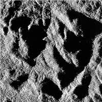
So rather than calling it “terrain masking” I should calling “terrain shadows” … I do know that we won’t detect what is behind the ridge of the hill, but I do not see any shadows on AG radar scope JP
…
http://i.imgur.com/Gm7t34N.jpg
If I am not wrong, in BMS, the radar mapping showed on the scope it taken from the top (god eye view) … it should be oblique … and should give shadows like above. (you necessary know what I mean since you made the TFR)
Additionally, the gain should also make the picture brighter on the bottom (closer => more energy & steeper angle) of the scope and darker on the top (further => less energy & shallower angle)
http://i.imgur.com/dWhgBvh.jpg
…
Should also have antenna pitch angle limitation … I am not sure it is implemented (I think we can scan the ground and get a picture on the scope even when flying at FL200 and looking with the radar 5NM in front of the a/c!)
http://i.imgur.com/9zBVWCE.jpg
1.8.7.4.4.6.1 Antenna tilt angle is automatically centered about the cursor position when the antenna tilt thumbwheel is in the detent. Moving antenna tilt away from detent offsets the scan coverage from the cursor position. At steep antenna tilt angles, the range extent of the coverage is reduced, sometimes illuminating a patch in range smaller than the selected display size. This is due to the limited vertical depth of the radar beam that covers only a portion of the entire range extent of the map.
Drawing terrain shading from a heightmap into a texture should not be that hard, generally speaking. Currently, BMS terrain isn’t shaded at all, maybe that is also why the Radar map doesn’t reflect that. If one day the terrain will have shading in 3D world, then drawing the same shading to a texture should be an easy task.
-
Hi Dee-jay
Are you going to improve the AG radar with all the features you’re describing? Don’t forget EXP and DBS modes, which are far from real now
Regards!
I’ve never said that.
Drawing terrain shading from a heightmap into a texture should not be that hard, generally speaking. Currently, BMS terrain isn’t shaded at all, maybe that is also why the Radar map doesn’t reflect that. If one day the terrain will have shading in 3D world, then drawing the same shading to a texture should be an easy task.
Thank you for info I-Hawk!
")
-
Absolutely one of the more interesting threads in a while on the forums! What a post and loved the suggestions, insight, and knowledge posted here. I’d like to see some shadowing on the radar display Dee-Jays example was great. Real world the AG radar can also be used (we are all gunna make the devs snap with the weather references and posts especially Mav JP lol) to scan for weather and convective cells down range. Can we get some tilt up and scan the sky too!
-
After reading this, along with the other improvement wish list threads, I think it is time we accept that the only way we will be able to meet future BMS user desired features is to infiltrate the US Military with our own people in real time to obtain the necessary data the devs need to model. No more short term solutions, we need a long range plan. May I suggest that we recruit from within:
1. Have all members identify military age family members
2. Dev’s choose best candidates and assign them to enlist in the specific service where information is desired, and volunteer for the specific job with that branch (in this case, radar technician for F-16’s, etc) where the information is needed by devs.This means updates could take a longer, 5-6 years possibly (if we start now), but man, will it be accurate! Ok, my moment of jesting is complete.
-
Dra If one day the terrain will have shading in 3D world, then drawing the same shading to a texture should be an easy task.
I think they are not asking for light source (sun) shading, rather for signal (radar) shading.
-
Ok, my moment of jesting is complete.
Sorry to say, but I think your comment can be potentially harmful for the team member, the forum itself and work plan.
-
I think they are not asking for light source (sun) shading, rather for signal (radar) shading.
Yep, radar shading depending on height and angle (LOS).
ASUSTeK ROG MAXIMUS X HERO / Intel Core i5-8600K (4.6 GHz) / NVIDIA GeForce RTX 3080 Ti FE 12GB / 32GB DDR4 Ballistix Elite 3200 MHz / Samsung SSD 970 EVO Plus 2TB / Be Quiet! Straight Power 11 1000W Platinum / Windows 10 Home 64-bit / HOTAS Cougar FSSB R1 (Warthog grip) / SIMPED / MFD Cougar / ViperGear ICP / SimShaker JetPad / Track IR 5 / Curved LED 27'' Monitor 1080p Samsung C27F396 / HP Reverb G2 VR Headset.
-
After reading this, along with the other improvement wish list threads, I think it is time we accept that the only way we will be able to meet future BMS user desired features is to infiltrate the US Military with our own people in real time to obtain the necessary data the devs need to model. No more short term solutions, we need a long range plan. May I suggest that we recruit from within:
1. Have all members identify military age family members
2. Dev’s choose best candidates and assign them to enlist in the specific service where information is desired, and volunteer for the specific job with that branch (in this case, radar technician for F-16’s, etc) where the information is needed by devs.This means updates could take a longer, 5-6 years possibly (if we start now), but man, will it be accurate! Ok, my moment of jesting is complete.
Sorry to say, but I think your comment can be potentially harmful for the team member, the forum itself and work plan.
Have to agree here… I know you mean it as a joke, but this is the kind of thing that is best not to be joked about. Not everyone has a sense of humor
-
No harm intended.