Kneemap POH 0.7.0
-
First airbases WIP for evaluation line of work.
Gibraltar, Jerez and Rota. Open the image in another window for full size.

-
As I can find the position of the TACAN station with respect to the airbase?
-
@Joe:
As I can find the position of the TACAN station with respect to the airbase?
Joe my friend, GREAT work there. Bravo!

Now one remark: If you want use an other one color for the sign of TACAN (and of course VORTAC) and for the data of NavAids/UHF-VHF/ILS in order to can be easily readed.
In order to can see the exact location of the TACAN station of each one airport, simply when you create a T.E. mission from an airport, then just take a look at the position of the STPT 1 (steerpoint 1) when you are inside cockpit. It is always the exact position of the TACAN station for all airports (not airstrips!).
I hope to help ;).
Nikos. -
Hello Joe, this is how it looks like in Jeppesen’s VFR sectionals.
187 is elevation in feet, 2459m is longest runway length. TWR is tower frequency. They only publish the VHF one here, but I think if you did like: TWR 118.100 249.0 it would be clear enough which one’s which. Also I think the ILS frequency isn’t needed here, it’s cluttering the chart and you really shouldn’t be looking for it there anyway, but rather in the approach chart.
-
Hey Joe,
This looks very nice. Great work mate.
-
I’m still doing tests. The purpose is that the data reading clearer.
TACAN and VORTAC icon thinner. See legend
Looking example of Gibraltar
Normal text (no bold)
Text and icons in black.
Text with white borderPlease reviews. Thank you.
Open image in another windows to full size
-
Nice Joe. I like it and find it good readable.
Now my remark is to replace the word “Tower:” with this one “TWR:” in order to gain some space especially at places that we have a lot of airports near.
Also at airports that we have both UHF and VHF frequencies and you have no room to add both of them, prefer to add the UHF one.
Thank you once again for your efforts!
By the way the fix is right for me. That means that you already released my hands and i can be on works again :p.
Nikos.PS. At the Legend, replace the words “Vortac” and “Tacan” with capitals, means with “VORTAC” and “TACAN” ;).
-
Not sure about the white cloud behind it. Have you tried white with purple stroke? Or the reverse, purple with white contour. It doesn’t need to be to wide, just 1 or 2 pixels of stroke wide, just enough to separate it from the background. Also, design student tip, avoid pure colors, try washed off shades of colors, they aren’t so aggressive on the sight. Besides that, all of the above said by ney
-
Hello Joe, this is how it looks like in Jeppesen’s VFR sectionals.
187 is elevation in feet, 2459m is longest runway length. TWR is tower frequency. They only publish the VHF one here, but I think if you did like: TWR 118.100 249.0 it would be clear enough which one’s which. Also I think the ILS frequency isn’t needed here, it’s cluttering the chart and you really shouldn’t be looking for it there anyway, but rather in the approach chart.
Agree.
Basically I would say just do the same as real ONC charts… nothing more nothing less
")
Anyway, good work!ASUSTeK ROG MAXIMUS X HERO / Intel Core i5-8600K (4.6 GHz) / NVIDIA GeForce RTX 3080 Ti FE 12GB / 32GB DDR4 Ballistix Elite 3200 MHz / Samsung SSD 970 EVO Plus 2TB / Be Quiet! Straight Power 11 1000W Platinum / Windows 10 Home 64-bit / HOTAS Cougar FSSB R1 (Warthog grip) / SIMPED / MFD Cougar / ViperGear ICP / SimShaker JetPad / Track IR 5 / Curved LED 27'' Monitor 1080p Samsung C27F396 / HP Reverb G2 VR Headset.
-
The lines of zones: is purple
I will use dark blue for airports (such as ONC Charts) … so it is less aggressive than pure black and differs as another color.
Softened white shading.
Change uppercase text.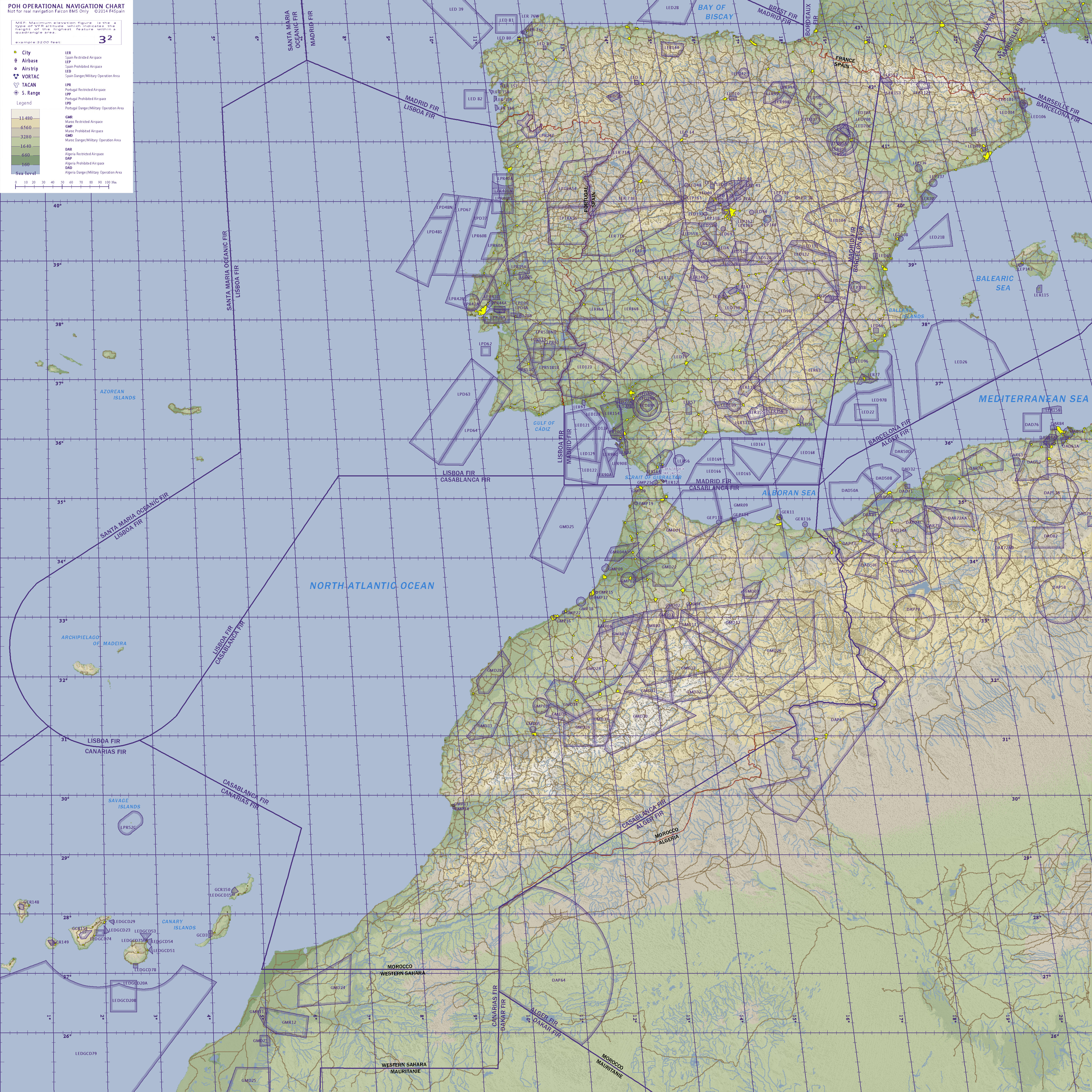
-
Nice Joe. I like it and find it good readable.
Now my remark is to replace the word “Tower:” with this one “TWR:” in order to gain some space especially at places that we have a lot of airports near.
Also at airports that we have both UHF and VHF frequencies and you have no room to add both of them, prefer to add the UHF one.
Thank you once again for your efforts!
By the way the fix is right for me. That means that you already released my hands and i can be on works again :p.
Nikos.PS. At the Legend, replace the words “Vortac” and “Tacan” with capitals, means with “VORTAC” and “TACAN” ;).
You have a PM…
-
-
@ Nicos
hit it hard and get it done
looking forward to a big theater with all the stuff working - Nav Aids - Charts and so on@ Joe
Great work, wonderfull map - outstanding theater with a lot of airspace to fly around.
Thanks to you, and all the people who are working on itCopy that. I’m “active” again ;).
Nikos. -
@ Nicos
hit it hard and get it done
looking forward to a big theater with all the stuff working - Nav Aids - Charts and so on@ Joe
Great work, wonderfull map - outstanding theater with a lot of airspace to fly around.
Thanks to you, and all the people who are working on itHey brother Reinhard, nice to see you.
Well thanks for your kindly words as also for your suggestions.
WE are on it, have faith… :p.
Great stuff is on the way, i can say only this for now.
After “working” like always NavAids it will follow a TACAN approach to Gibraltar as the first IAP chart. If i remember good, you LOVE TACAN approaches ;).
Nikos. -
Airbases Spain and Portugal added
Open image in another window
WIP:

-
GREAT work my friend Joe. BRAVO :p**!**
Nikos. -
To all the Devs from the POH
maybe this question was ask before - if so: " sorry for double posting :-)"
Question:
Are you planing on setting up Target/Fire Ranges in the POH as we have it in other Theaters ?
In such a big theater, I guess 4 or even 6 would be nice to have.
Maybe at:
Fuerteventura - GCD3
Western Sahara - GMD 23
Algeria - DAD 50F
Valladolid - LED 14
NW of Barcelona - LED 45
thx for keeping up the work on such a big theater
-
-
To all the Devs from the POH
maybe this question was ask before - if so: " sorry for double posting :-)"
Question:
Are you planing on setting up Target/Fire Ranges in the POH as we have it in other Theaters ?
In such a big theater, I guess 4 or even 6 would be nice to have.
Maybe at:
Fuerteventura - GCD3
Western Sahara - GMD 23
Algeria - DAD 50F
Valladolid - LED 14
NW of Barcelona - LED 45
thx for keeping up the work on such a big theater
Regarding:
LED 14 foot exercises Earth
Air-ground exercises GCD3
LED 45: exercises flying clubThe “shooting ranges” are identifiable from the air in Spain (the range of lasbardenas) and Portugal (the field alcochete) …. These two shooting ranges are extensive and are clearly identified.
Indeed there are more areas of air-ground training in Spain and Portugal … It’s easy to place objects, targets, vehicles, etc. in areas of air-ground training for areas ** D * air to ground exercises at the request of instructors (provided they are actual training areas and are used in the real world) are reflected in POH. Training areas would be less importances and not identifiable from the air …
For example the range of LED 14 is not clearly identified from the air and is very small … but could be placed targets, as … In this case this area is actually aimed at training ground shot.
Regarding:
Western Sahara - GMD 23
Algeria - DAD 50FI do not know these areas and achievement in google earth view any range. But it would be interesting to incorporate to Morocco (with its large airbase Benguerir and F-16) its own shooting range.
What and where is the great shooting range in Morocco?
In my opinion, I think with great shooting range by country (Spain, Portugal and Morocco) is enough. There are many areas of air-to-air training. And we can incorporate objects for ground-air training in other areas at the request of the instructors (those little areas, however will not have the magnitude of Alcochete or Bardenes as it is in the real world)
-
I took a look at the Moroccan AIP, their range is only GMD 06.
http://www.sia-aviation.gov.ma/eAIP/ENR/ENR5.1.pdf
